
On April 5, 2026, Planet Labs PBC confirmed it has indefinitely suspended the distribution of satellite imagery covering Iran and broader Middle East conflict zones.
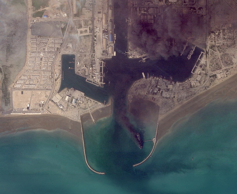
This policy shift follows a direct request from the United States government, specifically the administration’s national security team, to prevent commercial data from being leveraged for “tactical advantage” by adversarial actors. The restriction is retroactive to March 9, 2026, and replaces a previous 14-day delay policy with a more restrictive “managed access” model.
Under this new framework, Planet Labs will withhold high-resolution SkySat and medium-resolution PlanetScope data from its public-facing platforms. Access will now be granted only on a case-by-case basis for what the company defines as “mission-critical” requirements or specific public interest needs. This move represents a modernized application of “shutter control,” a regulatory power that allows the U.S. government to restrict commercial remote sensing during periods of heightened geopolitical tension.
Impact on Transparency and Global OSINT
The decision has created an immediate data void for journalists, human rights monitors, and open-source intelligence (OSINT) analysts. Organizations such as the IAEA and investigative outlets like Bellingcat have historically used Planet’s daily orbital scans to verify missile strikes, monitor nuclear facilities, and document human rights abuses in regions that are otherwise inaccessible. Without this “daily diary” of the planet, independent verification of events on the ground in Iran has become significantly more difficult.
Industry analysts note that while Planet Labs is the first to explicitly cite a government request, other major providers are following suit. Vantor (formerly Maxar) and BlackSky have also implemented tighter controls or delays on Middle East imagery. This coordinated “data blackout” is designed to protect U.S. and allied personnel from targeting by Iranian-aligned forces, who have increasingly used off-the-shelf satellite data to coordinate drone and missile logistics.
The Search for Alternative Imagery Sources
As Western providers tighten their archives, the OSINT community is pivoting toward non-U.S. constellations to fill the gap. European Space Agency (ESA) Sentinel data remains a primary alternative, though its lower resolution is less effective for detailed battle damage assessment. Researchers are also reportedly exploring access to international commercial providers based in jurisdictions outside U.S. “shutter control” reach, such as specialized Synthetic Aperture Radar (SAR) firms and certain Asian imaging constellations.
This shift underscores a growing tension in the space industry between the “democratization of data” and its integration into national defense architectures. As commercial satellites become essential tools for modern warfare, providers are being forced to balance their roles as transparent data utilities with their legal and ethical obligations to their home governments’ national security directives.
The U.S. government’s ability to restrict satellite imagery is not a single, unchallenged power but a complex legal structure that balances the First Amendment against the unique status of space-based observation as a matter of national security. While the Supreme Court has never issued a definitive ruling specifically on “shutter control”—the power to halt commercial satellite imaging—the current regulatory environment is built upon several key legal and historical pillars.
The Licensing Power and Regulatory Oversight
The primary source of government control lies in the licensing process managed by the National Oceanic and Atmospheric Administration (NOAA). Under the Land Remote Sensing Policy Act of 1992, any U.S. company wishing to operate a private remote sensing system must obtain a license. This license is not a broad grant of free speech but a conditional commercial permit. By accepting the license, companies like Planet Labs or Maxar formally agree to comply with “shutter control” provisions, which allow the Secretary of Commerce to limit or suspend operations to protect national security or foreign policy interests.
This regulatory framework effectively bypasses the high legal hurdle of “prior restraint.” In traditional media, the government must prove that publishing information would cause “direct, immediate, and irreparable damage” to the nation—a standard set in the 1971 Pentagon Papers case. However, because satellite operators are bound by the terms of their operating licenses, the government can enforce restrictions as a matter of contract and administrative law rather than seeking a court injunction to stop a broadcast or publication.
The Impact of the Kyl-Bingaman Amendment
A significant statutory precedent is the 1997 Kyl-Bingaman Amendment, which specifically prohibits U.S. satellite companies from distributing imagery of Israel at a resolution higher than what is available from non-U.S. commercial sources. This law is unique because it mandates the censorship of a specific geographic region based on the security concerns of a foreign ally. For over two decades, this resulted in the deliberate “blurring” of Israel and the Palestinian territories on public platforms like Google Earth.
The Kyl-Bingaman Amendment has never been successfully challenged in court on First Amendment grounds. Instead, its reach has been modulated by the principle of “technical parity.” In 2020, NOAA eased the resolution restrictions on imagery of Israel only after it was proven that international competitors, such as companies in Europe and South Korea, were already openly selling higher-resolution data. This transition suggests that the government views its power to restrict information as being tied to its ability to maintain a monopoly on that information.
“Buy-to-Deny” and Commercial Workarounds
The government has also established a precedent for restricting information through market intervention rather than legal force. During the early stages of the war in Afghanistan in 2001, the Pentagon avoided a potential First Amendment showdown over shutter control by utilizing a “buy-to-deny” strategy. The National Imagery and Mapping Agency (now the NGA) spent millions of dollars to purchase exclusive rights to all high-resolution imagery of the conflict zone from private providers.
By becoming the sole customer, the government effectively created a commercial blackout. Since the providers were fulfilling a lucrative contract rather than being forced to stop operations by a “gag order,” there was no legal “injury” for a news organization or NGO to challenge in court. This strategy demonstrated that financial leverage could be just as effective as regulatory power in controlling the flow of sensitive orbital data.
Contemporary Challenges and the FISC Precedent
While there is no direct Supreme Court ruling on shutter control, recent denials of review in related fields suggest a judicial reluctance to intervene in national security secrecy. In 2021, the Supreme Court declined to hear a challenge by the ACLU regarding the secrecy of the Foreign Intelligence Surveillance Court (FISC). Justices Gorsuch and Sotomayor dissented, noting that the “right of access” to judicial records is a fundamental tenet of the First Amendment, yet the majority left the system of secret surveillance opinions intact.
This trend indicates that in matters where technology and national security intersect, the courts often defer to the executive branch’s assessment of risk. For commercial satellite providers, this means that as long as their operations are tied to federal licenses and their primary customers remain government agencies, the “free flow of information” will continue to be managed by administrative policy rather than absolute constitutional protection.