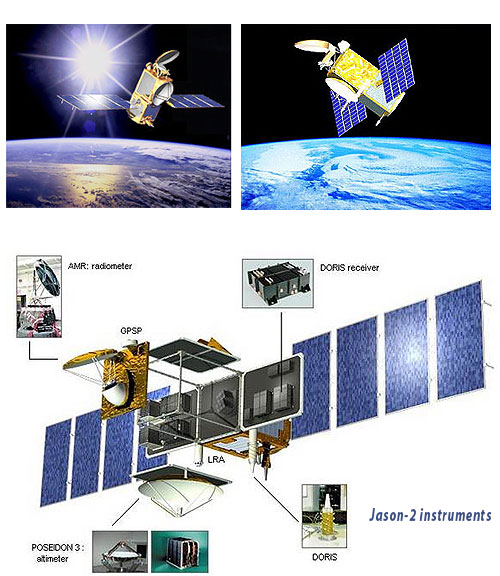
 NASA successfully launched on Friday a new NASA-French space agency oceanography satellite from Vandenberg Air Force Base, California, on a globe-circling voyage. The Ocean Surface Topography Mission/Jason 2 satellite will continue charting sea level, a vital indicator of global climate change. The mission will return a plethora of new data that will improve weather, climate and ocean forecasts.
Fifty-five minutes after launch, OSTM/Jason-2 separated from the rocket’s second stage, and then, unfurled its twin sets of solar arrays. Ground controllers successfully acquired the spacecraft’s signals. Initial telemetry reports show it to be in excellent health.
“Sea-level measurements from space have come of age,” said Michael Freilich, director of the Earth Science Division in NASA’s Science Mission Directorate, Washington. “Precision measurements from this mission will improve our knowledge of global and regional sea-level changes and enable more accurate weather, ocean and climate forecasts.”
 The measurements of sea-surface height, or ocean surface topography,
reveal the speed and direction of ocean currents and tell scientists
how much of the sun’s energy is stored by the ocean. Combining ocean
current and heat storage data is key to understanding global climate
variations. OSTM/Jason-2’s expected lifetime of at least three years
will extend into the next decade the continuous record of these data
started in 1992 by NASA and the French space agency Centre National
d’Etudes Spatiales, or CNES, with the TOPEX/Poseidon mission. The
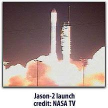
data collection was continued by the two agencies on Jason 1 in 2001. The Jason-2 satellite was built by Thales Alenia Space as prime contractor
The measurements of sea-surface height, or ocean surface topography,
reveal the speed and direction of ocean currents and tell scientists
how much of the sun’s energy is stored by the ocean. Combining ocean
current and heat storage data is key to understanding global climate
variations. OSTM/Jason-2’s expected lifetime of at least three years
will extend into the next decade the continuous record of these data
started in 1992 by NASA and the French space agency Centre National
d’Etudes Spatiales, or CNES, with the TOPEX/Poseidon mission. The
data collection was continued by the two agencies on Jason 1 in 2001. The Jason-2 satellite was built by Thales Alenia Space as prime contractor
The mission culminates more than three decades of research by NASA and CNES in this field. This expertise will be passed on to the world’s weather and environmental forecasting agencies, which will be responsible for collecting the data. The involvement of the National Oceanic and Atmospheric Administration (NOAA) and the European Organisation for the Exploitation of Meteorological Satellites (EUMETSAT) as mission partners on OSTM/Jason-2 helps establish this proven research capability as a valuable tool for use in everyday applications.
OSTM/Jason-2’s five primary instruments are improved versions of those flying on Jason 1. Based on a Proteus platform, Jason-2 carries the Poseidon-3 altimeter, which was also built by Thales Alenia Space. In addition to its unrivaled measurement precision, this instrument features an experimental mode capable of providing measurements near coastal zones, as well as on lakes and rivers.These technological advances will allow scientists to monitor conditions in ocean coastal regions — home to about half of Earth’s population. Compared with Jason 1 measurements, OSTM/Jason 2 will have substantially increased accuracy and provide data to within 15 miles of coastlines, nearly 50 percent closer to shore than in the past. This information is useful for those whose livlihood relys on the sea. NOAA will use the improved data to better predict hurricane intensity, which is directly affected by the amount of heat stored in the upper ocean.
OSTM/Jason-2 entered orbit about 6 to 9 miles below Jason 1. The new spacecraft will gradually use its thrusters to raise itself into the same 830-mile orbital altitude as Jason 1 and position itself to follow Jason 1’s ground track, orbiting about 60 seconds behind Jason 1. The two spacecraft will fly in formation, making nearly simultaneous measurements for about six months to allow scientists to precisely calibrate OSTM/Jason-2’s instruments.
Once cross-calibration is complete, Jason 1 will alter course, adjusting its orbit so that its ground tracks fall midway between those of OSTM/Jason-2. Together, the two spacecraft will double global coverage. This tandem mission will improve our knowledge of tides in coastal and shallow seas and internal tides in the open ocean, while improving our understanding of ocean currents and eddies.
CNES is providing the OSTM/Jason-2 spacecraft. NASA and CNES jointly are providing the primary payload instruments. NASA’s Launch Services Program at the Kennedy Space Center in Florida was responsible for launch management and countdown operations for the Delta II. NASA’s Jet Propulsion Laboratory in Pasadena, Calif., manages the mission for NASA’s Science Mission Directorate, Washington. The Jason-2 operational oceanography program is a quadripartite collaboration between CNES, NASA, and two meteorological organizations, Eumetsat and NOAA. The satellite will pave the way for new services, such as maritime forecasts for ships, and the coupling of this data with weather forecasts—Pasadena, California