
 GeoEye, Inc. [NASDAQ: GEOY] has received new awards totaling $22 million to supply geospatial products and related services to the National Geospatial-Intelligence Agency (NGA). Products include a significant amount of value-added, imagery-based geospatial-intelligence products including the company’s airport mapping product line. Imagery processing and production will be performed at GeoEye‘s advanced imagery processing centers located in St. Louis, Missouri and Thornton, Colorado. These awards are in addition to the task order for imagery purchases the company received from NGA last fall.
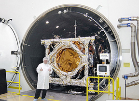
 Last month, the company announced an August 22, 2008 launch date for its nexgen, earth-imaging satellite GeoEye-1. Once launched, the satellite will be the world’s highest resolution commercial earth-imaging satellite. GeoEye-1 will be able to collect images with a ground resolution of 0.41-meters or 16 inches in the panchromatic, or black-and-white mode, and collect multispectral, or color imagery, at 1.65-meter resolution. The first stage of the United Launch Alliance Delta II launch vehicle has already arrived at Vandenberg Air Force Base, California—Dulles, Virginia