

• Skip to primary navigation
  • Skip to main content
  • Skip to primary sidebar
  • Skip to secondary sidebar
  • Skip to footer
  • NEWS:
  • SatNews
  • SatMagazine
  • MilSatMagazine
  • SmallSat News
  • |     EVENTS:
  • SmallSat Symposium
  • Satellite Innovation
  • MilSat Symposium
  • SmallSat Europe

SatNews

Satellite Industry Intelligence Since 1983

Subscribe
  • LATEST
  • SatNews Events
  • Magazines
  • Calendar
  • Subscribe
  • Missions & Constellations
    • Exploration & Science Missions
    • In-Orbit Servicing & Orbital Operations
    • LEO Constellations
    • Mission Autonomy & Onboard Systems
    • Mission Deployments & Manifests
    • Navigation & PNT
    • SmallSat
    • Spacecraft & Payload Technology
    View All in Missions & Constellations →
    Poland Just Made Sovereign SAR the European DefaultPoland Just Made Sovereign SAR the European Default
    SmallSat Europe Speaker Focus: John Rood, MomentusSmallSat Europe Speaker Focus: John Rood, Momentus
    Varda Space Industries W-6 Capsule Touches Down in South AustraliaVarda Space Industries W-6 Capsule Touches Down in South Australia
    LEO Constellations and Ground Infrastructure Scaling Position Optical Satcom for Multi-Billion-Dollar SurgeLEO Constellations and Ground Infrastructure Scaling Position Optical Satcom for Multi-Billion-Dollar Surge
  • Business
    • Contracts & Commercial Deals
    • Earnings & Financial Reporting
    • Events & Conferences
    • Funding & Venture Capital
    • Market Forecasts
    • Mergers & Acquisitions
    • Personnel Moves & Appointments
    View All in Business & Finance →
    Firefly Aerospace Doubles Spacecraft Infrastructure to Build Multi-Vehicle Production LineFirefly Aerospace Doubles Spacecraft Infrastructure to Build Multi-Vehicle Production Line
    Astroscale and SKY Perfect JSAT Alliance Signals Shift to In-Orbit Maintenance EconomyAstroscale and SKY Perfect JSAT Alliance Signals Shift to In-Orbit Maintenance Economy
    York Space Systems to Acquire Solestial to Verticalize Space Solar Supply ChainYork Space Systems to Acquire Solestial to Verticalize Space Solar Supply Chain
    Cowboy Raises $275M and Files for 20,000 Orbital Data Centers, Forcing the ODC Thesis Into ViewCowboy Raises $275M and Files for 20,000 Orbital Data Centers, Forcing the ODC Thesis Into View
  • Defense
    • Counterspace & ASAT
    • Defense Budgets & Procurement
    • ISR & Reconnaissance
    • MILSATCOM
    • Missile Warning & Defense
    • National Security Programs
    • Space Domain Awareness
    View All in Military & Defense →
    Pentagon Enforces Commercial Satellite Blackout Over Middle East War ZonePentagon Enforces Commercial Satellite Blackout Over Middle East War Zone
    iDirect Government Launches WCore to Virtualize Military Satellite ModemsiDirect Government Launches WCore to Virtualize Military Satellite Modems
    The transatlantic space defense timeline mismatch is now a NATO problemThe transatlantic space defense timeline mismatch is now a NATO problem
    Kymeta Flat Panel Antennas Integrated into Red Cat Variant 7 USV for Resilient Military SatcomKymeta Flat Panel Antennas Integrated into Red Cat Variant 7 USV for Resilient Military Satcom
  • Gov
    • Export Controls & Compliance
    • International Space Agreements
    • National Space Policy
    • Space Law & Treaties
    • Space Sustainability & Debris Policy
    • Space Traffic Management / Debris Removal
    View All in Government & Regulation →
    ESA and Spain Establish Formal Framework for Sovereign Satellite ConnectivityESA and Spain Establish Formal Framework for Sovereign Satellite Connectivity
    Do Satellite Providers Have a Say in Ground-Level RestrictionsDo Satellite Providers Have a Say in Ground-Level Restrictions
    SES Extends IRIS² Review as Consortium Reaches Initial Project MilestoneSES Extends IRIS² Review as Consortium Reaches Initial Project Milestone
    FCC Approves Landmark Spectrum Sharing and Direct-to-Device FrameworksFCC Approves Landmark Spectrum Sharing and Direct-to-Device Frameworks
  • Launch
    • Launch Providers
    • Launch Schedule & Calendars
    • Launch Sites & Infrastructure
    • Rocket Technology & Vehicles
    View All in Launch →
    Joint European-Chinese SMILE Mission Launches to Map Earth’s Magnetic ShieldJoint European-Chinese SMILE Mission Launches to Map Earth’s Magnetic Shield
    The Stratospheric Toll of the Megaconstellation EraThe Stratospheric Toll of the Megaconstellation Era
    NASA Outlines Preliminary Artemis III Low Earth Orbit Test Flight ProfileNASA Outlines Preliminary Artemis III Low Earth Orbit Test Flight Profile
    NASA and Eta Space Finalize Integration for LOXSAT Cryogenic Fuel DemonstrationNASA and Eta Space Finalize Integration for LOXSAT Cryogenic Fuel Demonstration
  • Software
    • Autonomous Ground Operations
    • Data Processing & AI/ML
    • Digital Twins & Modeling
    • Ground Segment & Teleports
    • Mission Planning & Simulation
    • Space Systems Software Engineering
    • Spectrum & Licensing
    View All in Software Automation & Ground Systems →
    Lightpath Expands Dense Northeast Fiber Infrastructure Across 2,400 Macro Cell TowersLightpath Expands Dense Northeast Fiber Infrastructure Across 2,400 Macro Cell Towers
    Teleste and Polystar Partner to Launch AI Automation for Next Generation Cable InfrastructureTeleste and Polystar Partner to Launch AI Automation for Next Generation Cable Infrastructure
    Astrolight and ESA Unveil Operational Optical Ground Station in Greece for Satellite Laser LinksAstrolight and ESA Unveil Operational Optical Ground Station in Greece for Satellite Laser Links
    Global Space Economy Reaches 429 Billion Dollars as Commercial Satellite Sector DominatesGlobal Space Economy Reaches 429 Billion Dollars as Commercial Satellite Sector Dominates
  • Services & Apps
    • Climate & Environmental Monitoring
    • Disaster Response & Security Mapping
    • Earth Observation & Imaging
    • Maritime & Aviation Satcom
    • Satellite Communications
    View All in Services & Applications →
    Apple Prepares for Pivot at WWDC 2026 MilestoneApple Prepares for Pivot at WWDC 2026 Milestone
    Energy Efficient E-Paper Displays Redefine Professional Digital SignageEnergy Efficient E-Paper Displays Redefine Professional Digital Signage
    Consumer NPU Boom Accelerates Autonomous Satellite ProcessingConsumer NPU Boom Accelerates Autonomous Satellite Processing
    Ted Turner: “Shake with Terror”Ted Turner: “Shake with Terror”

Spatial Surprises: Get A Snow Cone On Mars

September 24, 2009

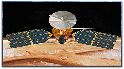
Mars Reconnaissance Orbiter (NASA JPL) NASA’s Mars Reconnaissance Orbiter has revealed frozen water hiding just below the surface of mid-latitude Mars — the spacecraft’s observations were obtained from orbit after meteorites excavated fresh craters on the Red Planet.

Scientists controlling instruments on the orbiter found bright ice exposed at five Martian sites, with new craters that range in depth from approximately 1.5 feet to 8 feet. The craters did not exist in earlier images of the same sites. Some of the craters show a thin layer of bright ice atop darker underlying material. The bright patches darkened in the weeks following initial observations, as the freshly exposed ice vaporized into the thin Martian atmosphere. One of the new craters had a bright patch of material large enough for one of the orbiter’s instruments to confirm it is water ice.

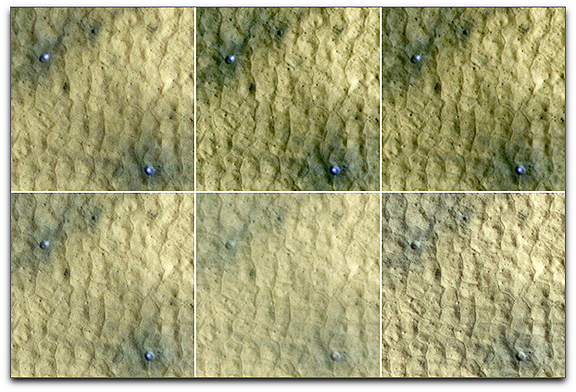
(Photo below: This series of images spanning a period of 15 weeks shows a pair of fresh, middle-latitude craters on Mars in which some bright, bluish material apparent in the earliest images disappears by the later ones. Each panel is 75 meters (246 feet) across. The two craters are each about 4 meters (13 feet) in diameter and half a meter (1.5 feet) deep.
NASA Mars Orbiter ice HiRISE camera

The bright material is water ice that was uncovered by the meteorite impact that excavated these small craters less than 15 weeks before the initial image of this series. Sublimation of the ice during the Martian summer leaves behind a dust layer that gradually thickens to the point where it obscures the ice.

The High Resolution Imaging Science Experiment (HiRISE) camera on NASA’s Mars Reconnaissance Orbiter took these images of this site at 46.33 degrees north latitude, 176.90 degrees east longitude. The HiRISE camera’s targeting of the site was prompted by two earlier images from the Context Camera on the Mars Reconnaissance Orbiter, which showed that the impact responsible for these craters had not yet occurred by June 4, 2008, but had occurred by Aug. 10, 2008.

The dates when these six HiRISE images were taken were (left to right, top row; then left to right, bottom row): Sept. 12, 2008; Sept. 28, 2008; Oct. 9, 2008; Oct. 14, 2008; Nov. 22, 2008; and Dec. 25, 2008. The span of time corresponded to a period from mid to late summer in Mars’ northern hemisphere. The images are subframes of the observations made on those dates.
)

The finds indicate water ice occurs beneath Mars’ surface halfway between the north pole and the equator, a lower latitude than expected in the Martian climate. “We now know we can use new impact sites as probes to look for ice in the shallow subsurface,” said Megan Kennedy of Malin Space Science Systems in San Diego, a co-author of the paper and member of the team operating the orbiter’s Context Camera.

During a typical week, the Context Camera returns more than 200 images of Mars that cover a total area greater than California. The camera team examines each image, sometimes finding dark spots that fresh, small craters make in terrain covered with dust. Checking earlier photos of the same areas can confirm a feature is new. The team has found more than 100 fresh impact sites, mostly closer to the equator than the ones that revealed ice. The Mars orbiter is designed to facilitate coordination and quick response by the science teams, making it possible to detect and understand rapidly changing features. The ice exposed by fresh impacts suggests that NASA’s Viking 2 lander, digging into mid-latitude Mars in 1976, might have struck ice if it had dug four inches deeper.

Filed Under: Exploration & Science Missions

Primary Sidebar

Coverage

  • Missions & Constellations
  • Business & Finance
  • Military & Defense
  • Launch
  • Software Automation & Ground Systems
  • Government & Regulation
  • Services & Applications

Most Read Stories

  • SmallSat Europe Speaker Focus: Merek Chertkow, The Radiation Team
  • Bad news, but good news followed
  • AST SpaceMobile Pivots to SpaceX for Mid-June Launch of Three BlueBird Satellites
  • FCC Grants AST SpaceMobile Authority for 248-Satellite Constellation and Direct-to-Cell Service
  • FAA Grounds Blue Origin Following New Glenn Upper Stage Failure and Facility Anomaly

Secondary Sidebar

Footer


Satnews is a leading provider of satellite news, events, publications, research and other satellite industry information in both commercial and military enterprises worldwide.

Stories By Category

  • Business & Finance
  • Government & Regulation
  • Launch
  • Military & Defense
  • Missions & Constellations
  • Services & Applications
  • Software Automation & Ground Systems
  • Spectrum & Licensing
  • Startups & NewSpace Business

About Us

  • Leadership & Editorial Team
  • SatNews History
  • Free Satnews Subscription
  • SatNews Events
  • Magazines

Navigation

  • Latest Stories
  • Magazines
  • Events
  • Contact
  • Cookie & Privacy Policy for Satnews

We use cookies to ensure that we give you the best experience on our website. If you continue to use this site we will assume that you are happy with it.
x
Sign up Now (For Free)
Access daily or weekly satellite news updates covering all aspects of the commercial and military satellite industry.
Invalid email address
Notify Me Regarding ( At least one ):
We value your privacy and will not sell or share your email or other information with any other company. You may also unsubscribe at anytime.

Click Here to see our full privacy policy.
Thanks for subscribing!