
 RAYTHEON — The Team GOES-R partnership led
by Raytheon Company (NYSE: RTN) has submitted its proposal to develop the
ground segment for the National Oceanic and Atmospheric Administration’s
nexgen Geostationary Operational Environmental Satellite series known as GOES-R. Scheduled for launch in 2015, GOES-R will include significant advancements in technology to provide sustained, reliable collection, analysis and distribution of data from the atmosphere, oceans, land and sun. The ground segment includes systems for command and control of the satellites, receiving and processing data, and generation and dissemination of improved environmental products to operational users within minutes. High-priority products can be delivered within seconds of the instrument observations.
RAYTHEON — The Team GOES-R partnership led
by Raytheon Company (NYSE: RTN) has submitted its proposal to develop the
ground segment for the National Oceanic and Atmospheric Administration’s
nexgen Geostationary Operational Environmental Satellite series known as GOES-R. Scheduled for launch in 2015, GOES-R will include significant advancements in technology to provide sustained, reliable collection, analysis and distribution of data from the atmosphere, oceans, land and sun. The ground segment includes systems for command and control of the satellites, receiving and processing data, and generation and dissemination of improved environmental products to operational users within minutes. High-priority products can be delivered within seconds of the instrument observations.
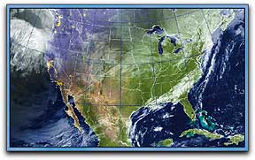 GOES-R satellites will provide more frequent and higher quality observations for more accurate forecasting and tracking of hurricanes and other severe weather. They will also enhance observational capabilities for oceans and coasts, the global climate, and the space environment. With rapid rescan capability, weather forecasters will be able to review updated severe weather activity 5x more quickly than today. As an example, GOES-R could rescan regional areas of the Midwest for severe thunderstorm outbreaks every five minutes instead of the current 26 minutes. The GOES-R contract is scheduled to be awarded in the first quarter of 2009.