• Skip to primary navigation
  • Skip to main content
  • Skip to primary sidebar
  • Skip to secondary sidebar
  • Skip to footer
  • NEWS:
  • SatNews
  • SatMagazine
  • MilSatMagazine
  • SmallSat News
  • |     EVENTS:
  • SmallSat Symposium
  • Satellite Innovation
  • MilSat Symposium
  • SmallSat Europe

SatNews

Satellite Industry Intelligence Since 1983

Subscribe
  • LATEST
  • SatNews Events
  • Magazines
  • Calendar
  • Subscribe
  • Missions & Constellations
    • Exploration & Science Missions
    • In-Orbit Servicing & Orbital Operations
    • LEO Constellations
    • Mission Autonomy & Onboard Systems
    • Mission Deployments & Manifests
    • Navigation & PNT
    • SmallSat
    • Spacecraft & Payload Technology
    View All in Missions & Constellations →
    SmallSat Europe Speaker Focus: Johannes Galatsanos, DiffraqtionSmallSat Europe Speaker Focus: Johannes Galatsanos, Diffraqtion
    Brian Cox Declares Humanity on the Threshold of Becoming a Multi-Planetary SpeciesBrian Cox Declares Humanity on the Threshold of Becoming a Multi-Planetary Species
    Access Hub and Maargin Release White Paper on Frugal LEO Constellations and Orbital AIAccess Hub and Maargin Release White Paper on Frugal LEO Constellations and Orbital AI
    SmallSat Europe Speaker Focus: Merek Chertkow, The Radiation Team
  • Business
    • Contracts & Commercial Deals
    • Earnings & Financial Reporting
    • Events & Conferences
    • Funding & Venture Capital
    • Market Forecasts
    • Mergers & Acquisitions
    • Personnel Moves & Appointments
    View All in Business & Finance →
    Sama Jordan TV Joins Es’hailSat Video Neighborhood at 26° EastSama Jordan TV Joins Es’hailSat Video Neighborhood at 26° East
    Anduril Secures $100M Modification to Modernize Space Surveillance NetworkAnduril Secures $100M Modification to Modernize Space Surveillance Network
    Real Wireless Tapped by UK Spectrum Policy Forum for Lunar Connectivity StudyReal Wireless Tapped by UK Spectrum Policy Forum for Lunar Connectivity Study
    PROFEN and Azercosmos Expand Satellite Services Across Europe, the Middle East, and AfricaPROFEN and Azercosmos Expand Satellite Services Across Europe, the Middle East, and Africa
  • Defense
    • Counterspace & ASAT
    • Defense Budgets & Procurement
    • ISR & Reconnaissance
    • MILSATCOM
    • Missile Warning & Defense
    • National Security Programs
    • Space Domain Awareness
    View All in Military & Defense →
    U.S. and Australia Expand Space Surveillance Network to Counter Emerging ASAT ThreatsU.S. and Australia Expand Space Surveillance Network to Counter Emerging ASAT Threats
    U.S. Space Force Awards $3.2 Billion for Space-Based Interceptor LayerU.S. Space Force Awards $3.2 Billion for Space-Based Interceptor Layer
    U.S. Space Force Integrates Domain Awareness Capabilities into Balikatan 2026U.S. Space Force Integrates Domain Awareness Capabilities into Balikatan 2026
    BAE Systems Enters Production for NavGuide M-Code GPS ReceiverBAE Systems Enters Production for NavGuide M-Code GPS Receiver
  • Gov
    • Export Controls & Compliance
    • International Space Agreements
    • National Space Policy
    • Space Law & Treaties
    • Space Sustainability & Debris Policy
    • Space Traffic Management / Debris Removal
    View All in Government & Regulation →
    UAE Space Agency Drives Public-Private Collaboration at MIITE 2026UAE Space Agency Drives Public-Private Collaboration at MIITE 2026
    SmallSat Europe Speaker Focus: Araz Feyzi, Kayhan SpaceSmallSat Europe Speaker Focus: Araz Feyzi, Kayhan Space
    Spectrum-Sharing Rules Get an OverhaulSpectrum-Sharing Rules Get an Overhaul
    NASA Objects to Blue Origin’s “Project Sunrise”NASA Objects to Blue Origin’s “Project Sunrise”
  • Launch
    • Launch Providers
    • Launch Schedule & Calendars
    • Launch Sites & Infrastructure
    • Rocket Technology & Vehicles
    View All in Launch →
    AST SpaceMobile Pivots to SpaceX for Mid-June Launch of Three BlueBird SatellitesAST SpaceMobile Pivots to SpaceX for Mid-June Launch of Three BlueBird Satellites
    SpaceX Accelerates Transition from Falcon 9 to Next-Generation Starship FleetSpaceX Accelerates Transition from Falcon 9 to Next-Generation Starship Fleet
    NanoAvionics Satellites Reach Orbit on SpaceX CAS500-2 MissionNanoAvionics Satellites Reach Orbit on SpaceX CAS500-2 Mission
    GalaxEye Successfully Launches “Mission Drishti” OptoSAR SatelliteGalaxEye Successfully Launches “Mission Drishti” OptoSAR Satellite
  • Software
    • Autonomous Ground Operations
    • Data Processing & AI/ML
    • Digital Twins & Modeling
    • Ground Segment & Teleports
    • Mission Planning & Simulation
    • Space Systems Software Engineering
    • Spectrum & Licensing
    View All in Software Automation & Ground Systems →
    SmallSat Europe Speaker Focus: Olaf Eckart, BMW GroupSmallSat Europe Speaker Focus: Olaf Eckart, BMW Group
    SES Accelerates Multi-Orbit IFC Strategy with meoSphere and Next-Gen ESA DevelopmentSES Accelerates Multi-Orbit IFC Strategy with meoSphere and Next-Gen ESA Development
    SmallSat Europe Speaker Focus: Koen Willems, ST Engineering iDirect EuropeSmallSat Europe Speaker Focus: Koen Willems, ST Engineering iDirect Europe
    GMV to Lead Mission Planning for ESA’s Next-Generation Copernicus ExpansionGMV to Lead Mission Planning for ESA’s Next-Generation Copernicus Expansion
  • Services & Apps
    • Climate & Environmental Monitoring
    • Disaster Response & Security Mapping
    • Earth Observation & Imaging
    • Maritime & Aviation Satcom
    • Satellite Communications
    View All in Services & Applications →
    Satellite Technology and the Legacy of the Media PioneerSatellite Technology and the Legacy of the Media Pioneer
    SmallSat Europe Speaker Focus: Massimo Comparini, Leonardo Space DivisionSmallSat Europe Speaker Focus: Massimo Comparini, Leonardo Space Division
    The waiver was the policy. Thursday is the paperwork.The waiver was the policy. Thursday is the paperwork.
    Solstar Confirms Successful On-Orbit Operation of Deke Space Communicator Following Launch on SpaceX Transporter-16 MissionSolstar Confirms Successful On-Orbit Operation of Deke Space Communicator Following Launch on SpaceX Transporter-16 Mission

First global image from NOAA-21’s CrIS Instrument

February 16, 2023

Three months after the NOAA-21 satellite launched from Vandenberg Space Force Base, an instrument onboard that provides valuable weather forecasting measurements to global weather models sent back its first science data.

The first light image in brightness temperature was captured by the NOAA-21 CrIS sensor at the 1596 cm-1 water vapor channel on February 12, 2023. This image shows the large-scale waves of upper tropospheric water vapor and clouds over the Earth’s globe. Image generated using NOAA-21 Preliminary, Non-Operational Data.

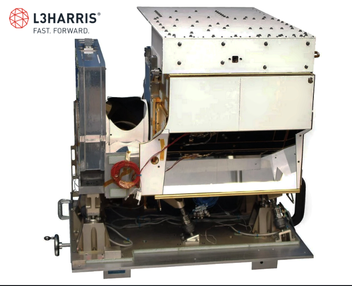
The data from the new, L3Harris produced, Cross-track Infrared Sounder (CrIS) instrument will continue the critical infrared soundings that play an important role in numerical weather prediction.

The L3Harris CrIS instrument will fly on all five JPSS satellites – Suomi-NPP (launched 2011), JPSS-1 (launched 2017), JPSS-2 (2022), JPSS-3 (~2026), JPSS-4 (~2031). Photo is courtesy of L3Harris.

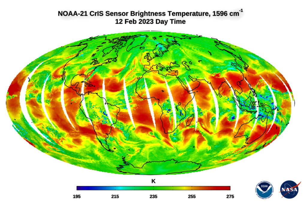
The infrared map above shows water vapor in the troposphere, the lower part of the atmosphere where we live and where weather happens. The red on the map likely indicates areas of drier air, where you’re seeing deeper into the atmosphere, said David Johnson, NOAA’s Joint Polar Satellite System’s (JPSS) CrIS instrument scientist.

“There’s that red area that’s over Hispaniola that’s about 275 degrees Kelvin and you go north of that off the mid-Atlantic coast and it’s about 240 degrees Kelvin, so that’s higher up in the atmosphere,” Johnson said. “That’s a region where there must be more water vapor in the atmosphere, since we cannot see through it to warmer air below.”

The CrIS sensor provides hyperspectral infrared observations from more than 2,211 channels with high radiometric and spectral accuracy. CrIS measures atmospheric temperature, surface temperature, and several trace gases in the atmosphere, including Carbon Dioxide (CO2), Ozone (O3), Methane (CH4), Sulfur Dioxide (SO2), Carbon Monoxide (CO), and Nitrous Oxide (N2O).

The CrIS sensor measures infrared spectra in three spectral bands: the long-wave IR (LWIR) band from 650 to 1095 cm-1, mid-wave IR (MWIR) band from 1210 to 1750 cm-1 and short-wave IR (SWIR) band from 2155 to 2550 cm-1.

When combined with measurements from the Advanced Technology Microwave Sounder (ATMS), these two instruments provide high quality measurements of atmospheric temperature and water vapor, which allow forecasters to predict extreme weather events like thunderstorms and atmospheric rivers, along with daily weather.

“CrIS takes detailed profiles of temperature and water vapor that forecasters use to measure atmospheric instability,” said NOAA’s JPSS Program Scientist, Dr. Satya Kalluri.

These first global images are part of a series of events that includes instrument activation, intensive calibration and validation activities that occur before the satellite is declared fully operational.

Together, NOAA and NASA oversee the development, launch, testing, and operation of all the satellites in the Joint Polar Satellite System program. NOAA funds and manages the program, operations, and data products. On behalf of NOAA, NASA and commercial partners develop and build the instruments, spacecraft, and ground system, and launch the satellites.

Filed Under: Climate & Environmental Monitoring, Military & Defense

Primary Sidebar

Coverage

  • Missions & Constellations
  • Business & Finance
  • Military & Defense
  • Launch
  • Software Automation & Ground Systems
  • Government & Regulation
  • Services & Applications

Most Read Stories

  • NASA Shuts Off Instrument on Voyager 1 to Extend Interstellar Mission
  • Bad news, but good news followed
  • FCC Modernizes Satellite Spectrum Rules to Unleash Next-Generation Broadband
  • Amazon to Acquire Globalstar for $11.6 Billion to Fuel D2D Expansion
  • The Smartest Money in the Room Is Looking Up

Secondary Sidebar

Footer


Satnews is a leading provider of satellite news, events, publications, research and other satellite industry information in both commercial and military enterprises worldwide.

Stories By Category

  • Business & Finance
  • Government & Regulation
  • Launch
  • Military & Defense
  • Missions & Constellations
  • Services & Applications
  • Software Automation & Ground Systems
  • Spectrum & Licensing
  • Startups & NewSpace Business

About Us

  • Leadership & Editorial Team
  • SatNews History
  • Free Satnews Subscription
  • SatNews Events
  • Magazines

Navigation

  • Latest Stories
  • Magazines
  • Events
  • Contact
  • Cookie & Privacy Policy for Satnews

We use cookies to ensure that we give you the best experience on our website. If you continue to use this site we will assume that you are happy with it.
x
Sign up Now (For Free)
Access daily or weekly satellite news updates covering all aspects of the commercial and military satellite industry.
Invalid email address
Notify Me Regarding ( At least one ):
We value your privacy and will not sell or share your email or other information with any other company. You may also unsubscribe at anytime.

Click Here to see our full privacy policy.
Thanks for subscribing!