• Skip to primary navigation
  • Skip to main content
  • Skip to primary sidebar
  • Skip to secondary sidebar
  • Skip to footer
  • NEWS:
  • SatNews
  • SatMagazine
  • MilSatMagazine
  • SmallSat News
  • |     EVENTS:
  • SmallSat Symposium
  • Satellite Innovation
  • MilSat Symposium
  • SmallSat Europe

SatNews

Satellite Industry Intelligence Since 1983

Subscribe
  • LATEST
  • SatNews Events
  • Magazines
  • Calendar
  • Subscribe
  • Missions & Constellations
    • Exploration & Science Missions
    • In-Orbit Servicing & Orbital Operations
    • LEO Constellations
    • Mission Autonomy & Onboard Systems
    • Mission Deployments & Manifests
    • Navigation & PNT
    • SmallSat
    • Spacecraft & Payload Technology
    View All in Missions & Constellations →
    Viasat Completes ViaSat-3 Constellation with Successful Flight 3 LaunchViasat Completes ViaSat-3 Constellation with Successful Flight 3 Launch
    GMV to Lead Mission Planning for ESA’s Next-Generation Copernicus ExpansionGMV to Lead Mission Planning for ESA’s Next-Generation Copernicus Expansion
    Canada Tightens Re-entry Regulations as SpaceX Starlink Constellations DescendCanada Tightens Re-entry Regulations as SpaceX Starlink Constellations Descend
    The waiver was the policy. Thursday is the paperwork.The waiver was the policy. Thursday is the paperwork.
  • Business
    • Contracts & Commercial Deals
    • Earnings & Financial Reporting
    • Events & Conferences
    • Funding & Venture Capital
    • Market Forecasts
    • Mergers & Acquisitions
    • Personnel Moves & Appointments
    View All in Business & Finance →
    SmallSat Europe Speaker Focus: Jorge Ciccorossi, ITU Radiocommunications BureauSmallSat Europe Speaker Focus: Jorge Ciccorossi, ITU Radiocommunications Bureau
    XDLINX Space Labs Inaugurates Advanced Satellite Integration Lab with ISRO LeadershipXDLINX Space Labs Inaugurates Advanced Satellite Integration Lab with ISRO Leadership
    SmallSat Europe Speaker Focus: Koen Willems, ST Engineering iDirect EuropeSmallSat Europe Speaker Focus: Koen Willems, ST Engineering iDirect Europe
    U.S. Commercial Service to Host “Future in Orbit” Networking Event at SpaceBR 2026U.S. Commercial Service to Host “Future in Orbit” Networking Event at SpaceBR 2026
  • Defense
    • Counterspace & ASAT
    • Defense Budgets & Procurement
    • ISR & Reconnaissance
    • MILSATCOM
    • Missile Warning & Defense
    • National Security Programs
    • Space Domain Awareness
    View All in Military & Defense →
    BAE Systems Enters Production for NavGuide M-Code GPS ReceiverBAE Systems Enters Production for NavGuide M-Code GPS Receiver
    Space Force Awards $3.2 Billion in Golden Dome Contracts for Orbital Interceptor ConstellationSpace Force Awards $3.2 Billion in Golden Dome Contracts for Orbital Interceptor Constellation
    USSF Finalizes GPS III Constellation with Successful SV-10 DeploymentUSSF Finalizes GPS III Constellation with Successful SV-10 Deployment
    Meink: Space Force Programs Ready to Execute Once FY27 Budget LandsMeink: Space Force Programs Ready to Execute Once FY27 Budget Lands
  • Gov
    • Export Controls & Compliance
    • International Space Agreements
    • National Space Policy
    • Space Law & Treaties
    • Space Sustainability & Debris Policy
    • Space Traffic Management / Debris Removal
    View All in Government & Regulation →
    ESA spells out satellite benefits – and risksESA spells out satellite benefits – and risks
    SmallSat Europe Speaker Focus: Tanja Masson-Zwaan, Leiden UniversitySmallSat Europe Speaker Focus: Tanja Masson-Zwaan, Leiden University
    How CubeSat Proliferation is Redefining Sovereignty and Diplomatic Leverage at the United NationsHow CubeSat Proliferation is Redefining Sovereignty and Diplomatic Leverage at the United Nations
    FCC Modernization of Spectrum Rules Unlocks Sevenfold Gain in Satellite CapacityFCC Modernization of Spectrum Rules Unlocks Sevenfold Gain in Satellite Capacity
  • Launch
    • Launch Providers
    • Launch Schedule & Calendars
    • Launch Sites & Infrastructure
    • Rocket Technology & Vehicles
    View All in Launch →
    GalaxEye Successfully Launches “Mission Drishti” OptoSAR SatelliteGalaxEye Successfully Launches “Mission Drishti” OptoSAR Satellite
    Foxconn Launches Second-Generation PEARL Satellites via SpaceX Falcon 9Foxconn Launches Second-Generation PEARL Satellites via SpaceX Falcon 9
    FAA Grounds Blue Origin Following New Glenn Upper Stage Failure and Facility AnomalyFAA Grounds Blue Origin Following New Glenn Upper Stage Failure and Facility Anomaly
    NanoAvionics to Launch Trio of Milestone Payloads on SpaceX CAS500-2 MissionNanoAvionics to Launch Trio of Milestone Payloads on SpaceX CAS500-2 Mission
  • Software
    • Autonomous Ground Operations
    • Data Processing & AI/ML
    • Digital Twins & Modeling
    • Ground Segment & Teleports
    • Mission Planning & Simulation
    • Space Systems Software Engineering
    • Spectrum & Licensing
    View All in Software Automation & Ground Systems →
    SES Accelerates Multi-Orbit IFC Strategy with meoSphere and Next-Gen ESA DevelopmentSES Accelerates Multi-Orbit IFC Strategy with meoSphere and Next-Gen ESA Development
    Global Invacom Secures Exclusive Worldwide Distribution for Prodelin Antenna RangeGlobal Invacom Secures Exclusive Worldwide Distribution for Prodelin Antenna Range
    SmallSat Europe Speaker Focus: Giovanni Pandolfi Bortoletto, Leaf SpaceSmallSat Europe Speaker Focus: Giovanni Pandolfi Bortoletto, Leaf Space
    SpinLaunch Selects Equinix to Deploy Global Ground Infrastructure for Meridian Space ConstellationSpinLaunch Selects Equinix to Deploy Global Ground Infrastructure for Meridian Space Constellation
  • Services & Apps
    • Climate & Environmental Monitoring
    • Disaster Response & Security Mapping
    • Earth Observation & Imaging
    • Maritime & Aviation Satcom
    • Satellite Communications
    View All in Services & Applications →
    Solstar Confirms Successful On-Orbit Operation of Deke Space Communicator Following Launch on SpaceX Transporter-16 MissionSolstar Confirms Successful On-Orbit Operation of Deke Space Communicator Following Launch on SpaceX Transporter-16 Mission
    IEC Telecom Unveils Voucher-Based Connectivity Solution at Singapore Maritime Week 2026IEC Telecom Unveils Voucher-Based Connectivity Solution at Singapore Maritime Week 2026
    GomSpace and STETMAN Establish UASAT Joint Venture for Ukrainian Sovereign CommunicationsGomSpace and STETMAN Establish UASAT Joint Venture for Ukrainian Sovereign Communications
    Market Dynamics and Non-Terrestrial Network (NTN) ChipsetsMarket Dynamics and Non-Terrestrial Network (NTN) Chipsets

Auburn University Researcher Demonstrates NASA Satellite’s Ability To Observe Forest Health

April 11, 2021

The image on the left illustrates an area analyzed by ICESat-2 and overlaid with imagery from the National Agriculture Imagery Program. On the right is an image generated from ICESat-2 combined with other data, showing aboveground biomass density for the study area. Darker shades of green indicate higher aboveground biomass densities. (contributed)

Lana Narine, an assistant professor of geospatial analytics in the Auburn University School of Forestry and Wildlife Sciences, is part of a research team whose recent study presented a breakthrough in the capabilities of a NASA satellite to examine the three-dimensional structure of forests.

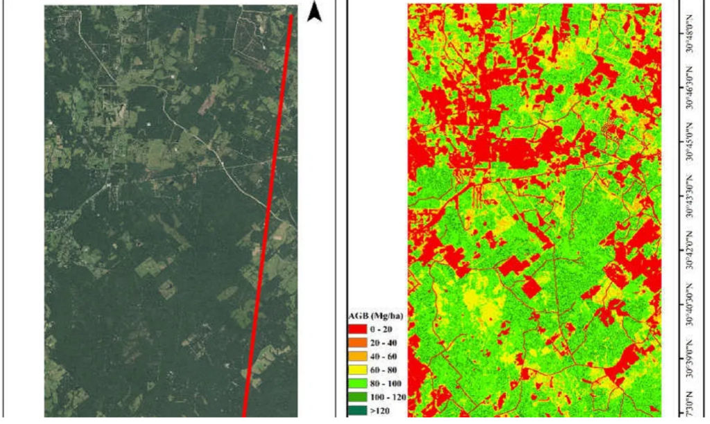
The study, “Using ICESat-2 to Estimate and Map Forest Aboveground Biomass: A First Example” in the journal Remote Sensing, shows how NASA’s Ice, Cloud and land Elevation Satellite-2, or ICESat-2, can be used to estimate aboveground biomass, or AGB, of forests and map its distribution.

Narine said limited information on the three-dimensional structure of forests has contributed to uncertainties in determining carbon budgets. However, ICESat-2 can capture this information using a laser-based lidar (light detection and ranging) instrument.

Lana Narine, an assistant professor of geospatial analytics in the Auburn University School of Forestry and Wildlife Sciences, is part of a research team whose recent study presented a breakthrough in the capabilities of the NASA satellite ICESat-2 to examine forest attributes. (Auburn University)

Lidar facilitates direct three-dimensional structural measurements, and using this technology from a space-based platform translates to exciting possibilities for assessing forest resources up to global scales, Narine said.

Knowing the capabilities of ICESat-2 allows for a better understanding of the satellite’s capabilities and limitations for characterizing vegetation.

“With ICESat-2 providing elevation measurements globally, a plethora of indicators of ecosystem health and function — including a key surrogate measure of forest AGB — can be potentially estimated to support sustainable management of forests,” Narine said.

The ICESat-2 mission was primarily designed to capture ice measurements, but its capture of data over vegetated areas offers investigators broader insights into ecosystem structure and the potential to contribute to the sustainable management of forest ecosystems.

Narine’s research implemented methods she worked on prior to the start of the mission to better understand the data and to develop methodologies for vegetation applications.

Janaki Alavalapati, dean of the School of Forestry and Wildlife Sciences, said the study is groundbreaking in its field.

“Dr. Narine’s role in researching the capabilities of the NASA Ice, Cloud and land Elevation Satellite-2 is yet another notable contribution from our faculty in the rapidly evolving field of geospatial and environmental informatics,” Alavalapati said. “This study has provided the first example of the satellite’s unique ability to gather critical data from forests that was previously unavailable.”

Narine’s co-authors were Sorin C. Popescu and Lonesome Malambo of the Department of Ecology and Conservation Biology at Texas A&M University, Narine’s former institution. Narine is a co-investigator on a NASA grant with the same team, with Popescu as principal investigator.

By Teri Greene, Auburn University

This story originally appeared on Auburn University’s website.

Filed Under: Climate & Environmental Monitoring, Earth Observation & Imaging

Primary Sidebar

Coverage

  • Missions & Constellations
  • Business & Finance
  • Military & Defense
  • Launch
  • Software Automation & Ground Systems
  • Government & Regulation
  • Services & Applications

Most Read Stories

  • Planet Labs Imposes Indefinite Blackout on Iran Satellite Imagery at U.S. Request
  • What the SpaceX IPO Changes for Every Satellite Operator
  • Russia Replaces Starlink With European-Built Satellites
  • NASA Shuts Off Instrument on Voyager 1 to Extend Interstellar Mission
  • Space42 and Viasat: Contract close for 2800 satellites

Secondary Sidebar

Footer


Satnews is a leading provider of satellite news, events, publications, research and other satellite industry information in both commercial and military enterprises worldwide.

Stories By Category

  • Business & Finance
  • Government & Regulation
  • Launch
  • Military & Defense
  • Missions & Constellations
  • Services & Applications
  • Software Automation & Ground Systems
  • Spectrum & Licensing
  • Startups & NewSpace Business

About Us

  • Leadership & Editorial Team
  • SatNews History
  • Free Satnews Subscription
  • SatNews Events
  • Magazines

Navigation

  • Latest Stories
  • Magazines
  • Events
  • Contact
  • Cookie & Privacy Policy for Satnews

We use cookies to ensure that we give you the best experience on our website. If you continue to use this site we will assume that you are happy with it.
x
Sign up Now (For Free)
Access daily or weekly satellite news updates covering all aspects of the commercial and military satellite industry.
Invalid email address
Notify Me Regarding ( At least one ):
We value your privacy and will not sell or share your email or other information with any other company. You may also unsubscribe at anytime.

Click Here to see our full privacy policy.
Thanks for subscribing!