[SatNews] PCI Geomatics now supports Landsat-8 imagery within its software suite.
Having officially entered its operation phase, Landsat-8 provides continuity to the Landsat Mission, which has been capturing imagery of the Earth since 1972, dating back to the original Landsat satellite, the Earth Resources Technology Satellite (ERTS), or Landsat-1.
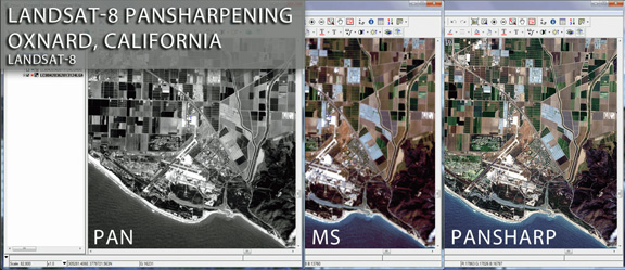
With PCI’s software, users will be able to perform essential image correction tasks such as pansharpening and mosaicking, which are common image processing tasks for Landsat imagery. The United States Geological Survey (USGS), who has taken over operations for Landsat-8, will distribute data according to the World Reference System-2 (WRS-2) collection grid, which often results in the need for multiple images to be used to cover areas of interest. These multiple images can be corrected and merged into a single pansharpened, mosaicked dataset though the use of PCI’s software.
PCI’s support for Landsat-8, which will be available in Geomatica 2013 SP2, includes rapid and high quality pansharpening capability as well as automated mosaicking. Landsat-8 imagery will be freely distributed through USGS, an estimated 400 images per day will be collected and made available through online data distribution portals such as Glovis, and EarthExplorer.
To view a sample of Landsat-8 imagery processed through PCI’s software, visit: www.pcigeomatics.com/images/landsat/l8_pansharp.png.