• Skip to primary navigation
  • Skip to main content
  • Skip to primary sidebar
  • Skip to secondary sidebar
  • Skip to footer
  • NEWS:
  • SatNews
  • SatMagazine
  • MilSatMagazine
  • SmallSat News
  • |     EVENTS:
  • SmallSat Symposium
  • Satellite Innovation
  • MilSat Symposium
  • SmallSat Europe

SatNews

Satellite Industry Intelligence Since 1983

Subscribe
  • LATEST
  • SatNews Events
  • Magazines
  • Calendar
  • Subscribe
  • Missions & Constellations
    • Exploration & Science Missions
    • In-Orbit Servicing & Orbital Operations
    • LEO Constellations
    • Mission Autonomy & Onboard Systems
    • Mission Deployments & Manifests
    • Navigation & PNT
    • SmallSat
    • Spacecraft & Payload Technology
    View All in Missions & Constellations →
    Viasat Completes ViaSat-3 Constellation with Successful Flight 3 LaunchViasat Completes ViaSat-3 Constellation with Successful Flight 3 Launch
    GMV to Lead Mission Planning for ESA’s Next-Generation Copernicus ExpansionGMV to Lead Mission Planning for ESA’s Next-Generation Copernicus Expansion
    Canada Tightens Re-entry Regulations as SpaceX Starlink Constellations DescendCanada Tightens Re-entry Regulations as SpaceX Starlink Constellations Descend
    The waiver was the policy. Thursday is the paperwork.The waiver was the policy. Thursday is the paperwork.
  • Business
    • Contracts & Commercial Deals
    • Earnings & Financial Reporting
    • Events & Conferences
    • Funding & Venture Capital
    • Market Forecasts
    • Mergers & Acquisitions
    • Personnel Moves & Appointments
    View All in Business & Finance →
    SmallSat Europe Speaker Focus: Jorge Ciccorossi, ITU Radiocommunications BureauSmallSat Europe Speaker Focus: Jorge Ciccorossi, ITU Radiocommunications Bureau
    XDLINX Space Labs Inaugurates Advanced Satellite Integration Lab with ISRO LeadershipXDLINX Space Labs Inaugurates Advanced Satellite Integration Lab with ISRO Leadership
    SmallSat Europe Speaker Focus: Koen Willems, ST Engineering iDirect EuropeSmallSat Europe Speaker Focus: Koen Willems, ST Engineering iDirect Europe
    U.S. Commercial Service to Host “Future in Orbit” Networking Event at SpaceBR 2026U.S. Commercial Service to Host “Future in Orbit” Networking Event at SpaceBR 2026
  • Defense
    • Counterspace & ASAT
    • Defense Budgets & Procurement
    • ISR & Reconnaissance
    • MILSATCOM
    • Missile Warning & Defense
    • National Security Programs
    • Space Domain Awareness
    View All in Military & Defense →
    BAE Systems Enters Production for NavGuide M-Code GPS ReceiverBAE Systems Enters Production for NavGuide M-Code GPS Receiver
    Space Force Awards $3.2 Billion in Golden Dome Contracts for Orbital Interceptor ConstellationSpace Force Awards $3.2 Billion in Golden Dome Contracts for Orbital Interceptor Constellation
    USSF Finalizes GPS III Constellation with Successful SV-10 DeploymentUSSF Finalizes GPS III Constellation with Successful SV-10 Deployment
    Meink: Space Force Programs Ready to Execute Once FY27 Budget LandsMeink: Space Force Programs Ready to Execute Once FY27 Budget Lands
  • Gov
    • Export Controls & Compliance
    • International Space Agreements
    • National Space Policy
    • Space Law & Treaties
    • Space Sustainability & Debris Policy
    • Space Traffic Management / Debris Removal
    View All in Government & Regulation →
    ESA spells out satellite benefits – and risksESA spells out satellite benefits – and risks
    SmallSat Europe Speaker Focus: Tanja Masson-Zwaan, Leiden UniversitySmallSat Europe Speaker Focus: Tanja Masson-Zwaan, Leiden University
    How CubeSat Proliferation is Redefining Sovereignty and Diplomatic Leverage at the United NationsHow CubeSat Proliferation is Redefining Sovereignty and Diplomatic Leverage at the United Nations
    FCC Modernization of Spectrum Rules Unlocks Sevenfold Gain in Satellite CapacityFCC Modernization of Spectrum Rules Unlocks Sevenfold Gain in Satellite Capacity
  • Launch
    • Launch Providers
    • Launch Schedule & Calendars
    • Launch Sites & Infrastructure
    • Rocket Technology & Vehicles
    View All in Launch →
    GalaxEye Successfully Launches “Mission Drishti” OptoSAR SatelliteGalaxEye Successfully Launches “Mission Drishti” OptoSAR Satellite
    Foxconn Launches Second-Generation PEARL Satellites via SpaceX Falcon 9Foxconn Launches Second-Generation PEARL Satellites via SpaceX Falcon 9
    FAA Grounds Blue Origin Following New Glenn Upper Stage Failure and Facility AnomalyFAA Grounds Blue Origin Following New Glenn Upper Stage Failure and Facility Anomaly
    NanoAvionics to Launch Trio of Milestone Payloads on SpaceX CAS500-2 MissionNanoAvionics to Launch Trio of Milestone Payloads on SpaceX CAS500-2 Mission
  • Software
    • Autonomous Ground Operations
    • Data Processing & AI/ML
    • Digital Twins & Modeling
    • Ground Segment & Teleports
    • Mission Planning & Simulation
    • Space Systems Software Engineering
    • Spectrum & Licensing
    View All in Software Automation & Ground Systems →
    SES Accelerates Multi-Orbit IFC Strategy with meoSphere and Next-Gen ESA DevelopmentSES Accelerates Multi-Orbit IFC Strategy with meoSphere and Next-Gen ESA Development
    Global Invacom Secures Exclusive Worldwide Distribution for Prodelin Antenna RangeGlobal Invacom Secures Exclusive Worldwide Distribution for Prodelin Antenna Range
    SmallSat Europe Speaker Focus: Giovanni Pandolfi Bortoletto, Leaf SpaceSmallSat Europe Speaker Focus: Giovanni Pandolfi Bortoletto, Leaf Space
    SpinLaunch Selects Equinix to Deploy Global Ground Infrastructure for Meridian Space ConstellationSpinLaunch Selects Equinix to Deploy Global Ground Infrastructure for Meridian Space Constellation
  • Services & Apps
    • Climate & Environmental Monitoring
    • Disaster Response & Security Mapping
    • Earth Observation & Imaging
    • Maritime & Aviation Satcom
    • Satellite Communications
    View All in Services & Applications →
    Solstar Confirms Successful On-Orbit Operation of Deke Space Communicator Following Launch on SpaceX Transporter-16 MissionSolstar Confirms Successful On-Orbit Operation of Deke Space Communicator Following Launch on SpaceX Transporter-16 Mission
    IEC Telecom Unveils Voucher-Based Connectivity Solution at Singapore Maritime Week 2026IEC Telecom Unveils Voucher-Based Connectivity Solution at Singapore Maritime Week 2026
    GomSpace and STETMAN Establish UASAT Joint Venture for Ukrainian Sovereign CommunicationsGomSpace and STETMAN Establish UASAT Joint Venture for Ukrainian Sovereign Communications
    Market Dynamics and Non-Terrestrial Network (NTN) ChipsetsMarket Dynamics and Non-Terrestrial Network (NTN) Chipsets

Here’s Looking @ Earth… When It Rains, It Definitely Pours (Imagery)

August 29, 2011

[SatNews] Although hurricanes often call to mind raging winds and toppling trees, some of the worst destruction caused by these storms comes in the form of rain.

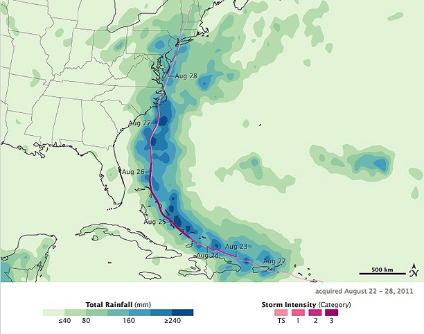
Hurricane Irene, which roared up the U.S. East Coast in late August 2011, was no exception. Flooding was reported from North Carolina’s Outer Banks to New England. This color-coded image (below) shows rainfall totals from August 22 to August 28, 2011. The heaviest rainfall—more than 240 millimeters or over 9 inches—appears in dark blue. The lightest rainfall—less than 40 millimeters or 1.5 inches—appears in light green. Superimposed on the rainfall totals is a storm track, with maroon indicating the strongest storm intensity, and pink indicating the weakest. Heavy rain occurs all along the storm track, and much of the heaviest rain falls over the ocean. On land, however, Hurricane Irene brought rain heavy enough to cause destructive floods.


NASA Earth Observatory image by Jesse Allen, using near-real-time data provided courtesy of TRMM Science Data and Information System at Goddard Space Flight Center. Caption by Michon Scott and Holli Riebeek.

At 8:00 a.m. Eastern Daylight Time on August 27, the U.S. National Hurricane Center (NHC) reported that the center of Irene made landfall near Cape Lookout, North Carolina. Nearby towns soon reported several feet of water on their roads, The New York Times said. As the storm slowly moved north, heavy rain and news reports of flooding followed. Streets flooded in Richmond, Virginia. River flooding around Philadelphia collapsed several buildings. Flooding struck all five boroughs in New York City, and several bridges were wiped out in the Catskills. Floods hit Vermont and New Hampshire harder than expected.

Although related, rainfall amounts and floods do not correspond exactly. How much flooding a certain amount of rainfall causes depends on many factors, such as vegetation, topography, soil type and land use, and previous weather patterns that may have saturated the soil. This may explain why more serious flooding was reported in the Northeast than in other areas receiving similar amounts of rain. According to news reports, authorities expressed particular concern about flooding in Vermont. On August 29, CNN reported that Irene was responsible for at least 24 deaths in nine states, and damage could total $7 billion, according to an analysis firm specializing in such estimates. Although significant, the damage could have been worse and was a fraction of the damage caused by Hurricane Katrina exactly six years earlier. Despite the destruction caused by the storm, much of the East Coast was returning to normal.

Besides the storm track and rainfall associated with Irene, this image shows a pocket of relatively heavy precipitation over the Atlantic Ocean (image right), which could be associated with Tropical Storm Jose. This image is based on data from the Multisatellite Precipitation Analysis produced at NASA’s Goddard Space Flight Center, which estimates rainfall by combining measurements from many satellites and calibrating them using rainfall measurements from the Tropical Rainfall Measuring Mission (TRMM) satellite. This image is an estimate of the rainfall recorded over a very large area when the satellites are overhead. The estimate may miss pockets of heavy rain in smaller areas or short periods of more or less intense rain. This means that local rainfall totals, measured from the ground, may be different from the estimate shown here. Satellite-based estimates provide a useful overview of broad rainfall patterns that, combined with ground measurements, provide a more complete picture of the storm.

Filed Under: Disaster Response & Security Mapping, Earth Observation & Imaging

Primary Sidebar

Coverage

  • Missions & Constellations
  • Business & Finance
  • Military & Defense
  • Launch
  • Software Automation & Ground Systems
  • Government & Regulation
  • Services & Applications

Most Read Stories

  • Planet Labs Imposes Indefinite Blackout on Iran Satellite Imagery at U.S. Request
  • What the SpaceX IPO Changes for Every Satellite Operator
  • Russia Replaces Starlink With European-Built Satellites
  • NASA Shuts Off Instrument on Voyager 1 to Extend Interstellar Mission
  • Space42 and Viasat: Contract close for 2800 satellites

Secondary Sidebar

Footer


Satnews is a leading provider of satellite news, events, publications, research and other satellite industry information in both commercial and military enterprises worldwide.

Stories By Category

  • Business & Finance
  • Government & Regulation
  • Launch
  • Military & Defense
  • Missions & Constellations
  • Services & Applications
  • Software Automation & Ground Systems
  • Spectrum & Licensing
  • Startups & NewSpace Business

About Us

  • Leadership & Editorial Team
  • SatNews History
  • Free Satnews Subscription
  • SatNews Events
  • Magazines

Navigation

  • Latest Stories
  • Magazines
  • Events
  • Contact
  • Cookie & Privacy Policy for Satnews

We use cookies to ensure that we give you the best experience on our website. If you continue to use this site we will assume that you are happy with it.
x
Sign up Now (For Free)
Access daily or weekly satellite news updates covering all aspects of the commercial and military satellite industry.
Invalid email address
Notify Me Regarding ( At least one ):
We value your privacy and will not sell or share your email or other information with any other company. You may also unsubscribe at anytime.

Click Here to see our full privacy policy.
Thanks for subscribing!