• Skip to primary navigation
  • Skip to main content
  • Skip to primary sidebar
  • Skip to secondary sidebar
  • Skip to footer
  • NEWS:
  • SatNews
  • SatMagazine
  • MilSatMagazine
  • SmallSat News
  • |     EVENTS:
  • SmallSat Symposium
  • Satellite Innovation
  • MilSat Symposium
  • SmallSat Europe

SatNews

Satellite Industry Intelligence Since 1983

Subscribe
  • LATEST
  • SatNews Events
  • Magazines
  • Calendar
  • Subscribe
  • Missions & Constellations
    • Exploration & Science Missions
    • In-Orbit Servicing & Orbital Operations
    • LEO Constellations
    • Mission Autonomy & Onboard Systems
    • Mission Deployments & Manifests
    • Navigation & PNT
    • SmallSat
    • Spacecraft & Payload Technology
    View All in Missions & Constellations →
    NASA Concludes Desert Field Testing for Autonomous Lunar Rover PrototypeNASA Concludes Desert Field Testing for Autonomous Lunar Rover Prototype
    Geospatial Advertising Convergence: Channel 4 and CACI Unveil “Geo Mapping” Tool for Hyper-Targeted Streaming CampaignsGeospatial Advertising Convergence: Channel 4 and CACI Unveil “Geo Mapping” Tool for Hyper-Targeted Streaming Campaigns
    Onboard Autonomy Hardening: BAE Systems and GlobalFoundries Validate Strategic Rad-Hard Endura Space ProcessorOnboard Autonomy Hardening: BAE Systems and GlobalFoundries Validate Strategic Rad-Hard Endura Space Processor
    NASA and Boeing are facing prolonged Starliner uncertainty.NASA and Boeing are facing prolonged Starliner uncertainty.
  • Business
    • Contracts & Commercial Deals
    • Earnings & Financial Reporting
    • Events & Conferences
    • Funding & Venture Capital
    • Market Forecasts
    • Mergers & Acquisitions
    • Personnel Moves & Appointments
    View All in Business & Finance →
    The Spatial Photonics Crunch: Inside the Invisible Supply Chain Threatening Orbital Laser NetworksThe Spatial Photonics Crunch: Inside the Invisible Supply Chain Threatening Orbital Laser Networks
    Sovereign Space Expansion: Spain’s FOSSA Systems Secures €9.25M to Scale Defense Constellation and SIGINT InfrastructureSovereign Space Expansion: Spain’s FOSSA Systems Secures €9.25M to Scale Defense Constellation and SIGINT Infrastructure
    Next-Gen Spatial Intelligence: BAE Systems Secures Agreement to Build High-Resolution Vantage Satellite Buses for VantorNext-Gen Spatial Intelligence: BAE Systems Secures Agreement to Build High-Resolution Vantage Satellite Buses for Vantor
    New Lobbying Force: Top NGSO Operators Unveil “SpaceConnect Association” in WashingtonNew Lobbying Force: Top NGSO Operators Unveil “SpaceConnect Association” in Washington
  • Defense
    • Counterspace & ASAT
    • Defense Budgets & Procurement
    • ISR & Reconnaissance
    • MILSATCOM
    • Missile Warning & Defense
    • National Security Programs
    • Space Domain Awareness
    View All in Military & Defense →
    Congressional Oversight Reassertion: House Appropriators Back $55.5 Billion Space Force Budget, Denouncing “Golden Dome” Funding ManeuversCongressional Oversight Reassertion: House Appropriators Back $55.5 Billion Space Force Budget, Denouncing “Golden Dome” Funding Maneuvers
    Digital Twins for Space Command: Sedaro Tapped by Space Force to Build Federated Engineering PlatformDigital Twins for Space Command: Sedaro Tapped by Space Force to Build Federated Engineering Platform
    The Strategic Redistribution of Iranian Aerospace CapabilityThe Strategic Redistribution of Iranian Aerospace Capability
    Navigating Contested Battlespaces: Military GPS Receiver Market Approaches $3 Billion Amid Electronic Warfare SurgeNavigating Contested Battlespaces: Military GPS Receiver Market Approaches $3 Billion Amid Electronic Warfare Surge
  • Gov
    • Export Controls & Compliance
    • International Space Agreements
    • National Space Policy
    • Space Law & Treaties
    • Space Sustainability & Debris Policy
    • Space Traffic Management / Debris Removal
    View All in Government & Regulation →
    Clearing C-band “will be expensive” says SESClearing C-band “will be expensive” says SES
    Hybrid Earth Intelligence: NASA Expands Commercial Satellite Data Integration in $476M Cloud-Driven PushHybrid Earth Intelligence: NASA Expands Commercial Satellite Data Integration in $476M Cloud-Driven Push
    $3.57 Billion Milestone: FCC Advanced Wireless Services (AWS-3) Spectrum Auction Concludes$3.57 Billion Milestone: FCC Advanced Wireless Services (AWS-3) Spectrum Auction Concludes
    Who Has Authority to Intervene in a Space-Based Emergency?Who Has Authority to Intervene in a Space-Based Emergency?
  • Launch
    • Launch Providers
    • Launch Schedule & Calendars
    • Launch Sites & Infrastructure
    • Rocket Technology & Vehicles
    View All in Launch →
    Arianespace fights back – possibly!Arianespace fights back – possibly!
    Direct-to-Device Momentum: AST SpaceMobile Successfully Launches Giant Next-Gen BlueBird Satellites Atop SpaceX Falcon 9Direct-to-Device Momentum: AST SpaceMobile Successfully Launches Giant Next-Gen BlueBird Satellites Atop SpaceX Falcon 9
    SpaceX’s Secret ‘Starfall’ Capsule Wins FAA Approval for Pacific Reentry TestsSpaceX’s Secret ‘Starfall’ Capsule Wins FAA Approval for Pacific Reentry Tests
    Breaking the TRL Bottleneck: Space Phoenix Systems Debuts Cost-Effective Space Test-and-Return ServiceBreaking the TRL Bottleneck: Space Phoenix Systems Debuts Cost-Effective Space Test-and-Return Service
  • Software
    • Autonomous Ground Operations
    • Data Processing & AI/ML
    • Digital Twins & Modeling
    • Ground Segment & Teleports
    • Mission Planning & Simulation
    • Space Systems Software Engineering
    • Spectrum & Licensing
    View All in Software Automation & Ground Systems →
    Powering the Automated Floor: Intralogistics Operators Must Unify AGV Charging InfrastructurePowering the Automated Floor: Intralogistics Operators Must Unify AGV Charging Infrastructure
    Poland Sovereignty: GMV to Develop Core Ground Control Platform for CAMILA ConstellationPoland Sovereignty: GMV to Develop Core Ground Control Platform for CAMILA Constellation
    Software Over the Air: FatPipe Launches Acceleration Tool to Unclog Starlink and Amazon LEO LinksSoftware Over the Air: FatPipe Launches Acceleration Tool to Unclog Starlink and Amazon LEO Links
    Three LEO Operators Bet 2026 on a Supply Chain Built for 2027Three LEO Operators Bet 2026 on a Supply Chain Built for 2027
  • Services & Apps
    • Climate & Environmental Monitoring
    • Disaster Response & Security Mapping
    • Earth Observation & Imaging
    • Maritime & Aviation Satcom
    • Satellite Communications
    View All in Services & Applications →
    The Silent Overhaul: How Software-Defined Routing and Cloud Ingestion Flattened the Aerospace Hardware StackThe Silent Overhaul: How Software-Defined Routing and Cloud Ingestion Flattened the Aerospace Hardware Stack
    National SAR Defense: Norway Selects ICEYE for Nationwide Space-Based Flood and Hazard Monitoring SystemNational SAR Defense: Norway Selects ICEYE for Nationwide Space-Based Flood and Hazard Monitoring System
    Hybrid Edge Mobility: Contrivian Launches “Horizon Plus” to Deliver Intelligent Multi-Orbit Field CommunicationsHybrid Edge Mobility: Contrivian Launches “Horizon Plus” to Deliver Intelligent Multi-Orbit Field Communications
    Sovereign Milestone: OQ Technology Achieves Europe’s First Drone Video Transmission via 3GPP NTN LEO SatelliteSovereign Milestone: OQ Technology Achieves Europe’s First Drone Video Transmission via 3GPP NTN LEO Satellite

U.S.A.F… A View From Above To Help Japan (UAS/UAV)

March 17, 2011


[SatNews] Reactor heat detection may be possible from aloft…


A U.S. Air Force Global Hawk UAV based out of Guam is tentatively scheduled to overfly the damaged reactors at the Fukushima Dai-1 nuclear plant in order to provide a more complete picture of what’s going on inside the facility. Japan has been battling a third potential catastrophe in the form of a nuclear meltdown. Dangerous levels of radiation are preventing nuclear workers and emergency responders from safely approaching the facility’s four reactors to control fires and assess the extent of damages. If the Global Hawk can provide detailed images of the buildings, it could be a big help for the authorities planning the next attempts to cool down the damaged reactors.


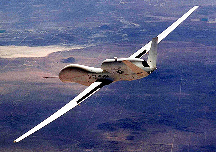
The Global Hawk is an autonomous, jet-powered UAV with a sensor package that includes synthetic-aperture radar as well as electro-optical and infrared sensors with telescopic capability for high-resolution imagery. The infrared sensors, which can detect heat, may be able to acquire images of the reactors showing which parts of them are at what temperatures, and repeated observations could provide critical data about the effectiveness of different attempts at cooling the reactor vessels and spent fuel pools.


Helicopters have already dumped approximately 30 tons of seawater on the No. 3 reactor building to attempt to cool it down, but officials are still trying to determine if such had any effect. Data from the Global Hawk’s sensors could potentially detect whether or not the seawater had an effect on the temperature inside the reactor, and therefore whether or not additional helicopter flights, or deploying truck-mounted water cannons, makes sense. For the past few days, the Global Hawk has been assisting with disaster relief efforts around Japan by collecting near real-time imagery which allows officials to better prioritize and direct their resources. This is a familiar role for the Global Hawk, which also helped to monitor the situation in Haiti after the 7.0 earthquake there in January of last year.


The Global Hawk, with a 35-meter wingspan, is capable of conducting surveillance for 36 hours at a stretch at altitudes of up to 18 kilometers (60,000 feet). It can survey 100,000 square kilometers (about 40,000 square miles) of terrain — the size of the state of Illinois — in a single day, entirely without human intervention: Once the robot receives its instructions, everything from taxiing to takeoff to data collection to landing is performed entirely autonomously. The drone was originally designed for the U.S. Air Force as a long-duration surveillance aircraft, and has a history of successful and effective use in Iraq and Afghanistan, offering on-demand near real-time imagery that can’t be provided by satellites. The platform proved to be successful enough that Global Hawks have been adapted for climate monitoring and environmental mapping, and NASA has a pair of the UAVs that it’s using as technology demonstrators. (Source: IEEE Spectrum).


Filed Under: Disaster Response & Security Mapping

Primary Sidebar

Coverage

  • Missions & Constellations
  • Business & Finance
  • Military & Defense
  • Launch
  • Software Automation & Ground Systems
  • Government & Regulation
  • Services & Applications

Most Read Stories

  • SpaceX’s Secret ‘Starfall’ Capsule Wins FAA Approval for Pacific Reentry Tests
  • American military space closed around one company in seven days
  • Analyst Projects Massive Subscription Growth for Starlink Ahead of Imminent SpaceX IPO
  • Major opportunities for 2 GHz over Europe
  • Amazon Leo Constellation Surpasses 330 Satellites Following Latest Atlas V Launch

Secondary Sidebar

Footer


Satnews is a leading provider of satellite news, events, publications, research and other satellite industry information in both commercial and military enterprises worldwide.

Stories By Category

  • Business & Finance
  • Government & Regulation
  • Launch
  • Military & Defense
  • Missions & Constellations
  • Services & Applications
  • Software Automation & Ground Systems
  • Spectrum & Licensing
  • Startups & NewSpace Business

About Us

  • Leadership & Editorial Team
  • SatNews History
  • Free Satnews Subscription
  • SatNews Events
  • Magazines

Navigation

  • Latest Stories
  • Magazines
  • Events
  • Contact
  • Cookie & Privacy Policy for Satnews

We use cookies to ensure that we give you the best experience on our website. If you continue to use this site we will assume that you are happy with it.
x
Sign up Now (For Free)
Access daily or weekly satellite news updates covering all aspects of the commercial and military satellite industry.
Invalid email address
Notify Me Regarding ( At least one ):
We value your privacy and will not sell or share your email or other information with any other company. You may also unsubscribe at anytime.

Click Here to see our full privacy policy.
Thanks for subscribing!