
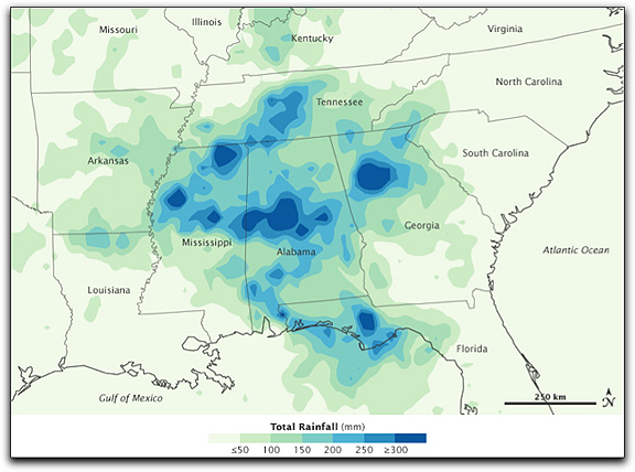
This image shows estimates of rainfall for the southeastern United States from September 14 to 21 produced by the near-real-time, multi-satellite precipitation analysis at NASA’s Goddard Space Flight Center. The analysis is based largely on observations from the Tropical Rainfall Measuring Mission (TRMM) satellite. The highest rainfall amounts — more than 300 millimeters (11.8 inches) — appear in blue. The lightest amounts appear in pale green. Rainfall occurred throughout Arkansas, Tennessee, Mississippi, Alabama, and Georgia. Especially intense rainfall occurred in Mississippi, Alabama, Georgia, and northern Florida. An area of low pressure over the lower Mississippi River Valley drew moisture up from the Gulf of Mexico northeastward over the American Southeast, fueling showers and thunderstorms. The low-pressure area persisted over the same location for several days, allowing rainfall totals to accumulate. (NASA image by Jesse Allen, using near-real-time data provided courtesy of the TRMM Science Data and Information System at Goddard Space Flight Center. Caption by Steve Lang (SSAI/NASA GSFC) and Michon Scott.)