
HELSINKI, FINLAND & BOSTON, MA — In a major development for weather-risk monetization, global insurer Liberty Mutual Reinsurance and satellite intelligence leader ICEYE announced a strategic partnership to launch a first-of-its-kind, building-level parametric wildfire insurance solution.
By leveraging high-resolution radar satellite data and automated machine learning, the product bypasses traditional, weeks-long claims adjustment pipelines. Instead, it triggers financial payouts within days of a fire being contained, providing immediate liquidity to municipalities, commercial portfolios, and critical infrastructure operators.
The commercial rollout lands as ICEYE rides massive corporate momentum. The Helsinki-based space firm recently finalized an explosive €1 billion Series F funding round led by General Atlantic, valuing the company at over €10 billion. Backed by a contracted backlog of €1.5 billion, ICEYE is aggressively using the capital injection to double its annual satellite production from 50 spacecraft to 100 units by 2028.
Piercing the Smoke with Synthetic Aperture Radar
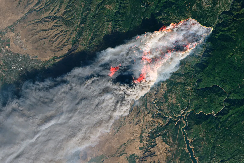
Traditional remote-sensing models used by insurers to calculate wildfire boundaries have historically relied on optical satellites, such as NASA’s Landsat or MODIS frameworks. While useful, optical imaging suffers from a critical structural vulnerability: it cannot see through physical obstructions. During active catastrophes, thick blankets of smoke, heavy cloud cover, or nighttime conditions can completely blind sensors, delaying damage assessments for days or weeks until the air clears.
The Liberty-ICEYE solution overcomes this physical barrier by utilizing ICEYE’s sovereign global constellation of Synthetic Aperture Radar (SAR) satellites. Unlike optical lenses, SAR instruments emit active radar pulses that ping the Earth’s surface and measure the signal bounce. These microwave frequencies effortlessly pierce through dense wildfire smoke clouds, ash plumes, and pitch darkness, ensuring reliable, uninterrupted data capture in near-real-time.
The Binary Payout: Eliminating the Loss Adjuster
The core mechanism of parametric insurance is that payouts are dictated by predefined physical parameters—such as a specific flood depth or wind speed—rather than a subjective financial evaluation of individual property damage.
Following a wildfire event, the platform executes a highly automated three-step tracking sequence:
- SAR Data Collection: ICEYE’s constellation maps the fire zone through the smoke.
- AI Layering: The high-resolution radar imagery is layered over detailed, pre-existing commercial and residential property footprint data.
- Machine Learning Classification: Advanced automated algorithms analyze the radar bounce characteristics of each structure.
The system classifies every insured property into a strict, transparent binary index: either “destroyed” or “undamaged.” Because the classification can be delivered within hours of an orbit pass, it completely eliminates the need for physical on-site visits, insurance loss adjusters, or prolonged litigation. When a property is flagged as destroyed by the algorithm, the agreed-upon parametric insurance payout is triggered automatically, transferring cash to the client’s account within days.
“By pushing the boundaries of technology, we are delivering a new generation of parametric wildfire coverage that is faster, more responsive, and fully data-driven,” said Jean-Christophe Garaix, Head of Parametrics & Agriculture at Liberty. “Our property wildfire cover is remotely sensed and designed to address the growing threat of wildfires, providing reliable protection alongside traditional insurance that allows for more efficient claims settlement.”
Bridging the Global Climate Protection Gap
As changing climate patterns increase the frequency, speed, and intensity of catastrophic wildfires, commercial markets are facing severe “protection gaps” as traditional indemnity insurance becomes prohibitively expensive or slow to pay out in high-risk zones.
The new parametric coverage is specifically designed to sit alongside traditional property policies, acting as an immediate financial shield for vulnerable entities:
- Municipalities & Public Risk Pools: Securing instant funds to restore civic infrastructure and clear roads.
- Homeowner Associations (HOAs): Disbursing rapid emergency liquidity to displaced residential communities.
- Critical Infrastructure Providers: Funding immediate grid or pipeline repairs to prevent regional economic paralysis.
- Reinsurers: Allowing institutional portfolios to hedge their commercial property exposure efficiently.
The parametric wildfire product is available immediately for risk profiles located across the United States and Australia, where wildfire exposures are exceptionally high. Liberty and ICEYE confirmed that the program is structured to scale globally into new territories as ICEYE continues to expand its orbital constellation and ground analytics infrastructure over the coming months.