• Skip to primary navigation
  • Skip to main content
  • Skip to primary sidebar
  • Skip to secondary sidebar
  • Skip to footer
  • NEWS:
  • SatNews
  • SatMagazine
  • MilSatMagazine
  • SmallSat News
  • |     EVENTS:
  • SmallSat Symposium
  • Satellite Innovation
  • MilSat Symposium
  • SmallSat Europe

SatNews

Satellite Industry Intelligence Since 1983

Subscribe
  • LATEST
  • SatNews Events
  • Magazines
  • Calendar
  • Subscribe
  • Missions & Constellations
    • Exploration & Science Missions
    • In-Orbit Servicing & Orbital Operations
    • LEO Constellations
    • Mission Autonomy & Onboard Systems
    • Mission Deployments & Manifests
    • Navigation & PNT
    • SmallSat
    • Spacecraft & Payload Technology
    View All in Missions & Constellations →
    SmallSat Europe Speaker Focus: Moritz Novak, GATE SpaceSmallSat Europe Speaker Focus: Moritz Novak, GATE Space
    Exotrail Confirms Successful Deployment of NASA-Funded AEPEX CubeSat via Spacevan 002Exotrail Confirms Successful Deployment of NASA-Funded AEPEX CubeSat via Spacevan 002
    Global Space Economy Reaches 429 Billion Dollars as Commercial Satellite Sector DominatesGlobal Space Economy Reaches 429 Billion Dollars as Commercial Satellite Sector Dominates
    SmallSat Europe Speaker Focus: Dr. Oguz Karasu, Oxford Saïd Business SchoolSmallSat Europe Speaker Focus: Dr. Oguz Karasu, Oxford Saïd Business School
  • Business
    • Contracts & Commercial Deals
    • Earnings & Financial Reporting
    • Events & Conferences
    • Funding & Venture Capital
    • Market Forecasts
    • Mergers & Acquisitions
    • Personnel Moves & Appointments
    View All in Business & Finance →
    Intuitive Machines to Acquire Goonhilly Earth Station and COMSAT to Scale Deep Space NetworkIntuitive Machines to Acquire Goonhilly Earth Station and COMSAT to Scale Deep Space Network
    Energy Efficient E-Paper Displays Redefine Professional Digital SignageEnergy Efficient E-Paper Displays Redefine Professional Digital Signage
    Gilat Wins Big Military Contracts, Expands India FootprintGilat Wins Big Military Contracts, Expands India Footprint
    Gen Z Influence on AI-Driven Audio MarketGen Z Influence on AI-Driven Audio Market
  • Defense
    • Counterspace & ASAT
    • Defense Budgets & Procurement
    • ISR & Reconnaissance
    • MILSATCOM
    • Missile Warning & Defense
    • National Security Programs
    • Space Domain Awareness
    View All in Military & Defense →
    iDirect Government Launches 450 Rackmount Software-Defined Modem for Multi-Orbit DefenseiDirect Government Launches 450 Rackmount Software-Defined Modem for Multi-Orbit Defense
    US Air Force Taps L3Harris to Bolster ABMS Digital InfrastructureUS Air Force Taps L3Harris to Bolster ABMS Digital Infrastructure
    U.S. and Australia Expand Space Surveillance Network to Counter Emerging ASAT ThreatsU.S. and Australia Expand Space Surveillance Network to Counter Emerging ASAT Threats
    U.S. Space Force Awards $3.2 Billion for Space-Based Interceptor LayerU.S. Space Force Awards $3.2 Billion for Space-Based Interceptor Layer
  • Gov
    • Export Controls & Compliance
    • International Space Agreements
    • National Space Policy
    • Space Law & Treaties
    • Space Sustainability & Debris Policy
    • Space Traffic Management / Debris Removal
    View All in Government & Regulation →
    SES Extends IRIS² Review as Consortium Reaches Initial Project MilestoneSES Extends IRIS² Review as Consortium Reaches Initial Project Milestone
    FCC Approves Landmark Spectrum Sharing and Direct-to-Device FrameworksFCC Approves Landmark Spectrum Sharing and Direct-to-Device Frameworks
    Satellite and the Upcoming Spectrum AuctionSatellite and the Upcoming Spectrum Auction
    ATVA Urges FCC to Close “Affiliation-Swap” Loopholes Impacting Satellite OperatorsATVA Urges FCC to Close “Affiliation-Swap” Loopholes Impacting Satellite Operators
  • Launch
    • Launch Providers
    • Launch Schedule & Calendars
    • Launch Sites & Infrastructure
    • Rocket Technology & Vehicles
    View All in Launch →
    SpaceX Debuts Starship V3: Redefining Heavy-Lift Launch CapabilitySpaceX Debuts Starship V3: Redefining Heavy-Lift Launch Capability
    AST SpaceMobile Pivots to SpaceX for Mid-June Launch of Three BlueBird SatellitesAST SpaceMobile Pivots to SpaceX for Mid-June Launch of Three BlueBird Satellites
    SpaceX Accelerates Transition from Falcon 9 to Next-Generation Starship FleetSpaceX Accelerates Transition from Falcon 9 to Next-Generation Starship Fleet
    NanoAvionics Satellites Reach Orbit on SpaceX CAS500-2 MissionNanoAvionics Satellites Reach Orbit on SpaceX CAS500-2 Mission
  • Software
    • Autonomous Ground Operations
    • Data Processing & AI/ML
    • Digital Twins & Modeling
    • Ground Segment & Teleports
    • Mission Planning & Simulation
    • Space Systems Software Engineering
    • Spectrum & Licensing
    View All in Software Automation & Ground Systems →
    SpinLaunch Partners with Aalyria for Meridian Constellation Network OrchestrationSpinLaunch Partners with Aalyria for Meridian Constellation Network Orchestration
    Your anomaly detection isn’t the problemYour anomaly detection isn’t the problem
    SmallSat Europe Speaker Focus: Olaf Eckart, BMW GroupSmallSat Europe Speaker Focus: Olaf Eckart, BMW Group
    SES Accelerates Multi-Orbit IFC Strategy with meoSphere and Next-Gen ESA DevelopmentSES Accelerates Multi-Orbit IFC Strategy with meoSphere and Next-Gen ESA Development
  • Services & Apps
    • Climate & Environmental Monitoring
    • Disaster Response & Security Mapping
    • Earth Observation & Imaging
    • Maritime & Aviation Satcom
    • Satellite Communications
    View All in Services & Applications →
    Consumer NPU Boom Accelerates Autonomous Satellite ProcessingConsumer NPU Boom Accelerates Autonomous Satellite Processing
    Ted Turner: “Shake with Terror”Ted Turner: “Shake with Terror”
    Satellite Technology and the Legacy of the Media PioneerSatellite Technology and the Legacy of the Media Pioneer
    SmallSat Europe Speaker Focus: Massimo Comparini, Leonardo Space DivisionSmallSat Europe Speaker Focus: Massimo Comparini, Leonardo Space Division

NASA Warms Up to Breaking the Ice With a Pod

April 30, 2009

Testing out new equipment is always an interesting endeavor and soon NASA will ‘break the ice’ on a pair of new airborne radars that can help monitor climate change when a team of scientists embarks this week on a two-month expedition to the vast, frigid terrain of Greenland and Iceland.

JPL pod plane Scientists from NASA’s Jet Propulsion Laboratory, Pasadena, California, and Dryden Flight Research Center, Edwards, California, will depart Dryden Friday, May 1, on a modified NASA Gulfstream III aircraft. In a pod beneath the aircraft’s fuselage will be two JPL-developed radars that are flying test beds for evaluating tools and technologies for future space-based radars.

An underbelly pod housing a Synthetic Aperture Radar designed for use on unmanned aircraft is prepared for flight tests on NASA’s Gulfstream III research testbed. NASA Dryden photo by Tom Tschida.

One of the radars, the L-band wavelength Uninhabited Aerial Vehicle Synthetic Aperture Radar, or UAVSAR, calibrates and supplements satellite data; the other is a proof-of-concept Ka-band wavelength radar called the Glacier and Land Ice Surface Topography Interferometer, or GLISTIN.

Both radars use pulses of microwave energy to produce images of Earth’s surface topography and the deformations in it. UAVSAR detects and measures the flow of glaciers and ice sheets, as well as subtle changes caused by earthquakes, volcanoes, landslides and other dynamic phenomena. GLISTIN will create high-resolution maps of ice surface topography, key to understanding the stresses that drive changes in glacial regions.

North Greenland During this expedition, UAVSAR will study the flow of Greenland’s and Iceland’s glaciers and ice streams, while GLISTIN will map Greenland’s icy surface topography. About 250,000 square kilometers (97,000 square miles) of land will be mapped during 110 hours of data collection.

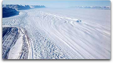
Petermann Floating Tongue in north Greenland. Image credit: NASA/JPL

“We hope to better characterize how Arctic ice is changing and how climate change is affecting the Arctic, while gathering data that will be useful for designing future radar satellites,” said UAVSAR Principal Investigator Scott Hensley of JPL.

The Gulfstream III flies at an altitude of 12,500 meters (41,000 feet) as UAVSAR collects data over areas of interest. The aircraft then flies over the same areas again, minutes to months later, using precision navigation to fly within 4.6 meters (15 feet) of its original flight path. By comparing the data from multiple passes, scientists can detect very subtle changes in Earth’s surface.

L-band Principal Investigator Howard Zebker of Stanford University, Palo Alto, California, and his team will use UAVSAR to collect data on various types of ice. They will measure how deeply the L-band radar penetrates the ice and compare it with similar C- and X-band radar data collected from satellites. Scientists expect the longer wavelengths of the L-band radar to penetrate deeper into the ice than C-band radar, “seeing” ice motions or structures hundreds of meters below the ice surface, rather than only at the surface. By using both wavelengths, scientists hope to obtain a more complete picture of how glaciers and ice streams flow. Zebker’s team will also evaluate how sensitive the L-band radar is to changes in the ice surface between observations.

To better predict how glaciers and ice sheets will evolve, scientists need to know what they’re doing now, how fast they’re changing, what processes drive the changes and how to represent them in models. Accurate measurements of ice sheet elevation derived from laser altimeters (lidars) on aircraft or satellites are critical to these efforts. But high-frequency microwave radars can also do the job, with greater coverage and the ability to operate in a wider range of weather conditions. Until now, however, microwave radars operating at wavelengths longer than those of GLISTIN have penetrated snow and ice more deeply than lidars, making interpretation of their data more complex.

Radar pod 
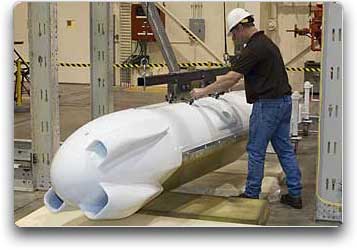
NASA Dryden lead technician David Neufeld prepares JPL’s unmanned aircraft Synthetic Aperture Radar pod for inertial swing tests in Dryden’s loads laboratory. NASA Dryden photo by Tom Tschida.

Enter GLISTIN, the first demonstration of millimeter-wave interferometry, which was developed to support International Polar Year studies. Principal Investigator Delwyn Moller of Remote Sensing Solutions, Barnstable, Massachusetts, and her team will evaluate GLISTIN’s ability to map ice surface topography. GLISTIN has two receiving antennas, separated by about 25 centimeters (10 inches). This gives it stereoscopic vision and the ability to simultaneously generate both imagery and topographic maps. The topographic maps are accurate to within 10 centimeters (4 inches) of elevation on scales comparable to the ground footprint of a lidar on a satellite.

Scientists expect GLISTIN to penetrate the snow and ice by just centimeters, rather than by meters, as current microwave radars do. A multi-institutional team will conduct coordinated lidar and ground measurements to help quantify how deeply GLISTIN’s Ka-band radar penetrates the snow and ice and to verify model predictions.

GLISTIN data will aid in designing future Earth ice topography missions and even missions to map ice on other celestial bodies. Scientists will also apply its data to designing missions to map Earth’s surface water and ocean topography.

A joint partnership of JPL and Dryden, UAVSAR evolved from JPL’s airborne synthetic aperture radar (AIRSAR) system that flew on NASA’s DC-8 aircraft in the 1990s. In 2004, NASA’s Earth Science Technology Office funded development of a more compact version of AIRSAR to be flown on uninhabited aerial vehicles. UAVSAR made its first operational flight in November 2008. JPL is managed for NASA by the California Institute of Technology in Pasadena.

Filed Under: Climate & Environmental Monitoring

Primary Sidebar

Coverage

  • Missions & Constellations
  • Business & Finance
  • Military & Defense
  • Launch
  • Software Automation & Ground Systems
  • Government & Regulation
  • Services & Applications

Most Read Stories

  • NASA Shuts Off Instrument on Voyager 1 to Extend Interstellar Mission
  • Bad news, but good news followed
  • AST SpaceMobile Pivots to SpaceX for Mid-June Launch of Three BlueBird Satellites
  • Blue Origin Achieves First Booster Reuse but Satellite Enters Off-Nominal Orbit
  • SmallSat Europe Speaker Focus: Merek Chertkow, The Radiation Team

Secondary Sidebar

Footer


Satnews is a leading provider of satellite news, events, publications, research and other satellite industry information in both commercial and military enterprises worldwide.

Stories By Category

  • Business & Finance
  • Government & Regulation
  • Launch
  • Military & Defense
  • Missions & Constellations
  • Services & Applications
  • Software Automation & Ground Systems
  • Spectrum & Licensing
  • Startups & NewSpace Business

About Us

  • Leadership & Editorial Team
  • SatNews History
  • Free Satnews Subscription
  • SatNews Events
  • Magazines

Navigation

  • Latest Stories
  • Magazines
  • Events
  • Contact
  • Cookie & Privacy Policy for Satnews

We use cookies to ensure that we give you the best experience on our website. If you continue to use this site we will assume that you are happy with it.
x
Sign up Now (For Free)
Access daily or weekly satellite news updates covering all aspects of the commercial and military satellite industry.
Invalid email address
Notify Me Regarding ( At least one ):
We value your privacy and will not sell or share your email or other information with any other company. You may also unsubscribe at anytime.

Click Here to see our full privacy policy.
Thanks for subscribing!