
On May 19, 2026, the European Space Agency (ESA) and the Chinese Academy of Sciences (CAS) achieved a major milestone in international aerospace cooperation with the successful launch of the Solar wind Magnetosphere Ionosphere Link Explorer (SMILE) mission.
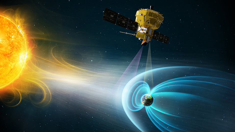
Dropped into orbit by a Vega-C rocket from Europe’s Spaceport in Kourou, French Guiana, the three-year scientific spacecraft is tasked with capturing the first continuous, global X-ray and ultraviolet views of the dynamic boundary where the solar wind collides with Earth’s magnetic shield.
Advanced Sensors Drive the Soft X-ray Imager
A core technical enabler for the historic heliophysics mission is its Soft X-ray Imager (SXI). Developed and procured by ESA, the instrument relies on two custom CCD370 imaging sensors manufactured, tested, and qualified by Chelmsford, England-based Teledyne Space Imaging.
The specialized sensors are engineered to observe low-energy, soft X-ray photons ranging from 0.2 to 2.0 kiloelectronvolts (keV). These precise wavelengths are generated through a process known as Solar Wind Charge Exchange, which occurs when highly charged solar ions slam into neutral particles within the outermost fringes of Earth’s upper atmosphere. By capturing these emissions, the SXI will allow scientists to map the physical shape and movement of the magnetopause—the invisible boundary layer where the planet’s magnetic field deflects the continuous stream of solar radiation.
Highly Elliptical Orbit for Macro-Scale Mapping
To achieve a comprehensive field of view, SMILE must escape the immediate proximity of the lower atmosphere to observe the Earth-Sun boundary from a macro perspective. Over the course of the next month, the spacecraft’s integrated propulsion module will execute a series of maneuvers to transition from its initial injection altitude into a highly inclined, highly elliptical polar orbit.
The planned operational trajectory involves distinct orbital parameters optimized for continuous observation:
- Apogee Altitude: The spacecraft will swing out to approximately 121,000 kilometers above the North Pole, reaching roughly one-third of the distance to the Moon. At this high altitude, the instruments can continuously monitor the dayside magnetopause for up to 40 uninterrupted hours per orbit.
- Perigee Altitude: SMILE will dive down to approximately 5,000 kilometers over the South Pole, utilizing this low point to downlink accumulated scientific data to ground stations, including the Bernardo O’Higgins research station in Antarctica.
- Orbital Inclination: The trajectory is set at a steep 73-degree angle relative to the equator, granting the payload a clear, overhead view of the northern polar cusp and the auroral oval.
A Full-Stack Toolset for Space Weather Tracking
While the Teledyne-powered SXI captures the wide-angle X-ray boundary data, the satellite utilizes a suite of three additional instruments to correlate those images with real-time plasma measurements. An ultraviolet imager (UVI) will track the global structural changes of the northern auroras, while an in-situ plasma analyzer and magnetometer measure the simultaneous velocity, density, and magnetic properties of the incoming solar wind.
David Morris, Chief Engineer at Teledyne Space Imaging, emphasized that this unique instrumentation suite marks the first time scientists can actively image Earth’s magnetosphere using X-ray light. By turning raw, high-altitude energy exchanges into a continuous stream of diagnostic data, the SMILE mission is positioned to significantly improve global space weather forecasting models. This capability is increasingly vital for safeguarding commercial communication satellites, stabilizing orbital data centers, and protecting terrestrial electrical grids from the disruptive currents generated by severe geomagnetic storms.