• Skip to primary navigation
  • Skip to main content
  • Skip to primary sidebar
  • Skip to secondary sidebar
  • Skip to footer
  • NEWS:
  • SatNews
  • SatMagazine
  • MilSatMagazine
  • SmallSat News
  • |     EVENTS:
  • SmallSat Symposium
  • Satellite Innovation
  • MilSat Symposium
  • SmallSat Europe

SatNews

Satellite Industry Intelligence Since 1983

Subscribe
  • LATEST
  • SatNews Events
  • Magazines
  • Calendar
  • Subscribe
  • Missions & Constellations
    • Exploration & Science Missions
    • In-Orbit Servicing & Orbital Operations
    • LEO Constellations
    • Mission Autonomy & Onboard Systems
    • Mission Deployments & Manifests
    • Navigation & PNT
    • SmallSat
    • Spacecraft & Payload Technology
    View All in Missions & Constellations →
    Iridium Unveils Core Role in Artemis II and Next-Gen PNT at Space Symposium 2026Iridium Unveils Core Role in Artemis II and Next-Gen PNT at Space Symposium 2026
    Boeing and Millennium Unveil Resolute Mid-Class Satellite PlatformBoeing and Millennium Unveil Resolute Mid-Class Satellite Platform
    NASA Shifts Focus to Permanent Lunar Base and Nuclear PropulsionNASA Shifts Focus to Permanent Lunar Base and Nuclear Propulsion
    Kepler and Astrolight Secure ESA Contract for HydRON Optical NetworkKepler and Astrolight Secure ESA Contract for HydRON Optical Network
  • Business
    • Contracts & Commercial Deals
    • Earnings & Financial Reporting
    • Events & Conferences
    • Funding & Venture Capital
    • Market Forecasts
    • Mergers & Acquisitions
    • Personnel Moves & Appointments
    View All in Business & Finance →
    Geographic Hotspots: Where Demand Is AcceleratingGeographic Hotspots: Where Demand Is Accelerating
    SmallSat Europe Speaker Focus: Martin Langer, OroraTechSmallSat Europe Speaker Focus: Martin Langer, OroraTech
    SmallSat Europe Speaker Focus: Jaume Sanpera, SateliotSmallSat Europe Speaker Focus: Jaume Sanpera, Sateliot
    Ericsson Initiates SEK 15 Billion Share Buyback ProgramEricsson Initiates SEK 15 Billion Share Buyback Program
  • Defense
    • Counterspace & ASAT
    • Defense Budgets & Procurement
    • ISR & Reconnaissance
    • MILSATCOM
    • Missile Warning & Defense
    • National Security Programs
    • Space Domain Awareness
    View All in Military & Defense →
    Saltzman Unveils 2040 Blueprint to Scale Space Force for Great Power CompetitionSaltzman Unveils 2040 Blueprint to Scale Space Force for Great Power Competition
    The Rise of Grey Zone Satellites: Ambiguity as a Tactical AdvantageThe Rise of Grey Zone Satellites: Ambiguity as a Tactical Advantage
    SmallSat Europe Speaker Focus: Col. Marcin Mazur, Polish Space AgencySmallSat Europe Speaker Focus: Col. Marcin Mazur, Polish Space Agency
    US Space Force Awards $68.6M Modification to Lockheed Martin for Next-Gen OPIRUS Space Force Awards $68.6M Modification to Lockheed Martin for Next-Gen OPIR
  • Gov
    • Export Controls & Compliance
    • International Space Agreements
    • National Space Policy
    • Space Law & Treaties
    • Space Sustainability & Debris Policy
    • Space Traffic Management / Debris Removal
    View All in Government & Regulation →
    SmallSat Europe Speaker Focus: Chris Quilty, Quilty SpaceSmallSat Europe Speaker Focus: Chris Quilty, Quilty Space
    NRL to Showcase Sovereign Space Capabilities at 41st Space SymposiumNRL to Showcase Sovereign Space Capabilities at 41st Space Symposium
    FCC Modernizes Satellite Spectrum Rules to Unleash Next-Generation BroadbandFCC Modernizes Satellite Spectrum Rules to Unleash Next-Generation Broadband
    SmallSat Europe Speaker Focus: Daniel Bock, Morpheus SpaceSmallSat Europe Speaker Focus: Daniel Bock, Morpheus Space
  • Launch
    • Launch Providers
    • Launch Schedule & Calendars
    • Launch Sites & Infrastructure
    • Rocket Technology & Vehicles
    View All in Launch →
    Ensign-Bickford Hardware Supports Successful Artemis II Lunar MissionEnsign-Bickford Hardware Supports Successful Artemis II Lunar Mission
    China Accelerates Orbital Internet Deployment with Successful Smart Dragon-3 Sea LaunchChina Accelerates Orbital Internet Deployment with Successful Smart Dragon-3 Sea Launch
    What the SpaceX IPO Changes for Every Satellite OperatorWhat the SpaceX IPO Changes for Every Satellite Operator
    €30 million Financing for PLD Space’s Small Satellite Launcher€30 million Financing for PLD Space’s Small Satellite Launcher
  • Software
    • Autonomous Ground Operations
    • Data Processing & AI/ML
    • Digital Twins & Modeling
    • Ground Segment & Teleports
    • Mission Planning & Simulation
    • Space Systems Software Engineering
    • Spectrum & Licensing
    View All in Software Automation & Ground Systems →
    Blue Origin Unveils Project Quartz Global Ground Station NetworkBlue Origin Unveils Project Quartz Global Ground Station Network
    Cloudcomputing Targets 1.5M Identities in Spain and Finalizes Innovate IT AcquisitionCloudcomputing Targets 1.5M Identities in Spain and Finalizes Innovate IT Acquisition
    Archangel Lightworks Secures £10M Series A to Scale Optical Ground InfrastructureArchangel Lightworks Secures £10M Series A to Scale Optical Ground Infrastructure
    Keysight and Sateliot Win ESA and GSMA Foundry Challenge for 6G InnovationKeysight and Sateliot Win ESA and GSMA Foundry Challenge for 6G Innovation
  • Services & Apps
    • Climate & Environmental Monitoring
    • Disaster Response & Security Mapping
    • Earth Observation & Imaging
    • Maritime & Aviation Satcom
    • Satellite Communications
    View All in Services & Applications →
    NASA Targets Commercial Relays to Replace Aging TDRSS InfrastructureNASA Targets Commercial Relays to Replace Aging TDRSS Infrastructure
    OQ Technology Awarded ESA Contract to Adapt 5G Beamforming for SpaceOQ Technology Awarded ESA Contract to Adapt 5G Beamforming for Space
    Kraken Robotics Integrates KATFISH Sonar on SEFINE RD-22 USV Following Multi-Naval DemonstrationsKraken Robotics Integrates KATFISH Sonar on SEFINE RD-22 USV Following Multi-Naval Demonstrations
    Astroscale Plans World-First Multi-Orbit Satellite Inspection MissionAstroscale Plans World-First Multi-Orbit Satellite Inspection Mission

NOAA satellites tracked historic levels of harmful smoke that impacted millions in the Eastern U.S.

June 20, 2023

In stark contrast to the white clouds, thick grayish smoke can be seen over the eastern U.S. via NOAA’s GOES-16 (GOES East) satellite on June 6, 2023. Image is courtesy of the agency.

NOAA satellites provided critical data for air quality forecasters when wildfires, burning near Quebec, Canada, sent billowing plumes of smoke over the eastern United States. The satellite data allowed NOAA scientists to estimate that more than 86 million people experienced fine particulate pollution levels higher than the federal health standard.

Artistic rendition of NOAA’s GOES East satellite on-orbit, courtesy of the agency

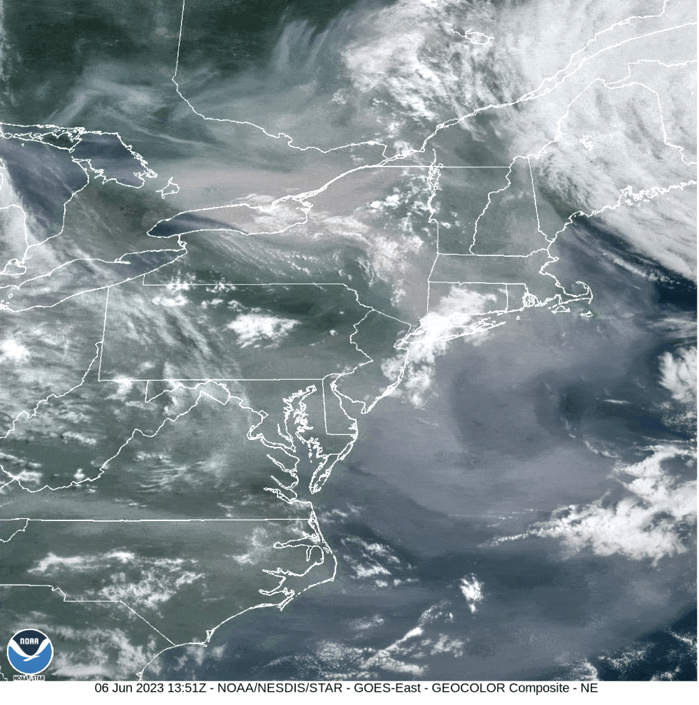
Observations from the Advanced Baseline Imager on the GOES East satellite tracked the progression of the worst air quality, shown by the red, purple, and maroon shading in the figure below, starting in the Great Lakes on June 5 and moving to New York State and southern New England on June 6, then pushing southward into the Mid-Atlantic region on June 7–8. These historic fine particulate pollution levels were the highest recorded for many cities, including New York City, Philadelphia, and Washington, D.C.

Extreme wildland fires have become the norm rather than the exception in recent years, with many wildfires being ignited by lightning in a warming and drying climate. The impacts of smoke in the U.S. mostly have been experienced by those in the western states, particularly in California, Oregon, and Washington, where residents have suffered very high levels of pollution from wildfires. In contrast, the eastern U.S. had largely escaped the effects of wildfire smoke on air quality, until recently.

During the early-June episode, NOAA satellite observations of the smoke helped forecasters issue air quality alerts to protect public health.

“Satellite resources, such as NOAA’s AerosolWatch website, provide operationally critical, real-time information on smoke content in the atmosphere and vital lead time for us to communicate impending impacts to surface air quality,” said Joel Dreessen, Air Quality Forecaster at the Maryland Department of the Environment.

“The last major smoke episode of a similar magnitude that impacted air quality in the eastern U.S. occurred in July 2002, over 20 years ago,” said Amy Huff, Ph.D., of IM Systems Group, who supports NOAA’s Center for Satellite Applications and Research (STAR)’s air quality work. But last week’s event is unlikely to be a rare occurrence. Smoke transport from wildfires is expected to become more frequent in the eastern U.S., where it will have a greater impact on public health because of the region’s many dense urban population centers.

“NOAA’s geostationary satellite data of fine particulate pollution increasingly are being used in nowcasting mode to provide warnings to the public,” said Shobha Kondragunta, Ph.D., who leads the air quality studies at STAR. In addition, NOAA satellite observations of wildland fires provide critical input to forecast models on fire locations and the amount of smoke and other pollutants emitted by wildfires that impact air quality downwind.

“Our operational air quality forecast models use these satellite observations as input to predict the impact of wildfires on air quality,” said Ivanka Stajner, Ph.D., Deputy Director of the Environmental Modeling Center at NOAA’s National Weather Service (NWS). The operational air quality forecast guidance is produced by NWS twice daily and is used by state and local air quality forecasters to issue air quality alerts to states and 360 cities and counties nationwide to help protect people from harmful exposure to smoky air. Air quality forecasts and current nowcast observations are available on AirNow.gov.

“These satellite data are also used extensively by NOAA researchers to improve the treatment of smoke emissions, plume transport, and atmospheric chemistry in the next-generation air quality forecasting systems,” said Gregory Frost, Ph.D., Supervisory Research Chemist in the Chemical Sciences Laboratory of NOAA’s Office of Oceanic and Atmospheric Research.

The wildfire smoke had a stunning impact on human exposure to harmful air quality, according to estimates from NOAA’s Visible Infrared Imaging Radiometer Suite sensor on the NOAA-20 and Suomi NPP satellites. The designated colored areas in the figure below include more than 17 million people in major cities such as New York City, Philadelphia, and Washington, D.C, who were breathing “Very Unhealthy” air.

“The smoke is a mixture of very small particles and gases that can cause a variety of heart and lung problems when breathed in, and the satellite-based information on air pollution levels helps people avoid exposure to these harmful pollutants,” said Susan Anenberg, Professor and Chair of the Environmental and Occupational Health department at George Washington University.

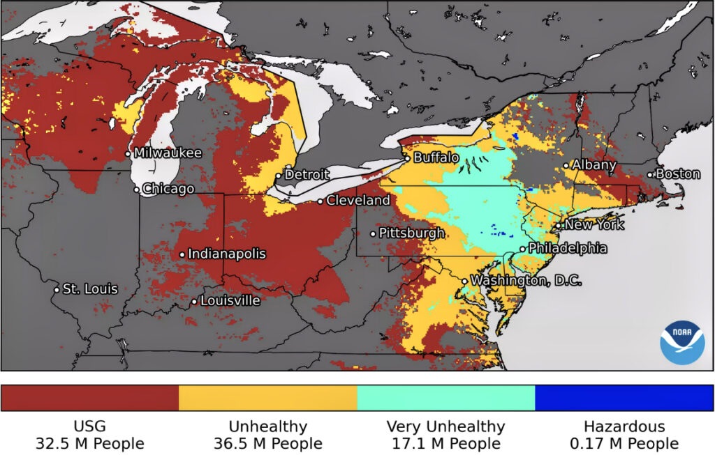
Millions (“M”) of people in the U.S. were exposed to harmful particulate pollution (PM2.5) on June 3-10, broken down by Air Quality Index (AQI) level, estimated from measurements of aerosol optical depth (AOD) made by NOAA’s Visible Infrared Imaging Radiometer Suite (VIIRS) on the NOAA-20 and SNPP satellites; gray indicates regions not impacted or no data. “USG” stands for “Unhealthy for Sensitive Groups” which includes children, senior citizens, and people with respiratory and/or cardiovascular diseases. Regions in Canada were not part of the analysis.

Collecting smoke observations daily and creating a long-term record allows NOAA to put these events in context. “Instantaneous estimates of the number of people exposed to harmful levels of smoke are only possible because of near real-time processing of NOAA satellite data,” Kondragunta said. “This information is critical for issuing timely air quality alerts and reducing people’s exposure to harmful smoke.”

Filed Under: Climate & Environmental Monitoring, Disaster Response & Security Mapping, Government & Regulation

Primary Sidebar

Coverage

  • Missions & Constellations
  • Business & Finance
  • Military & Defense
  • Launch
  • Software Automation & Ground Systems
  • Government & Regulation
  • Services & Applications

Most Read Stories

  • SpaceX Loses Contact With Starlink Satellite
  • Rocket Lab Emerging as Potential Bus Provider for 2,800-Satellite Equatys Constellation
  • SpaceX Accelerates Record-Breaking IPO Following Trillion-Dollar xAI Merger
  • Planet Labs Imposes Indefinite Blackout on Iran Satellite Imagery at U.S. Request
  • Amazon in Reported Talks to Acquire Globalstar in $9 Billion Move to Challenge Starlink

Secondary Sidebar

Footer


Satnews is a leading provider of satellite news, events, publications, research and other satellite industry information in both commercial and military enterprises worldwide.

Stories By Category

  • Business & Finance
  • Government & Regulation
  • Launch
  • Military & Defense
  • Missions & Constellations
  • Services & Applications
  • Software Automation & Ground Systems
  • Spectrum & Licensing
  • Startups & NewSpace Business

About Us

  • Leadership & Editorial Team
  • SatNews History
  • Free Satnews Subscription
  • SatNews Events
  • Magazines

Navigation

  • Latest Stories
  • Magazines
  • Events
  • Contact
  • Cookie & Privacy Policy for Satnews

We use cookies to ensure that we give you the best experience on our website. If you continue to use this site we will assume that you are happy with it.
x
Sign up Now (For Free)
Access daily or weekly satellite news updates covering all aspects of the commercial and military satellite industry.
Invalid email address
Notify Me Regarding ( At least one ):
We value your privacy and will not sell or share your email or other information with any other company. You may also unsubscribe at anytime.

Click Here to see our full privacy policy.
Thanks for subscribing!