• Skip to primary navigation
  • Skip to main content
  • Skip to primary sidebar
  • Skip to secondary sidebar
  • Skip to footer
  • NEWS:
  • SatNews
  • SatMagazine
  • MilSatMagazine
  • SmallSat News
  • |     EVENTS:
  • SmallSat Symposium
  • Satellite Innovation
  • MilSat Symposium
  • SmallSat Europe

SatNews

Satellite Industry Intelligence Since 1983

Subscribe
  • LATEST
  • SatNews Events
  • Magazines
  • Calendar
  • Subscribe
  • Missions & Constellations
    • Exploration & Science Missions
    • In-Orbit Servicing & Orbital Operations
    • LEO Constellations
    • Mission Autonomy & Onboard Systems
    • Mission Deployments & Manifests
    • Navigation & PNT
    • SmallSat
    • Spacecraft & Payload Technology
    View All in Missions & Constellations →
    Interlune Secures $6.9 Million NASA Contract for Lunar Resource ExtractionInterlune Secures $6.9 Million NASA Contract for Lunar Resource Extraction
    Smallsat Sector to Deploy 16,900 Satellites Through 2035 as Market Reaches Industrial MaturitySmallsat Sector to Deploy 16,900 Satellites Through 2035 as Market Reaches Industrial Maturity
    NanoAvionics Satellites Reach Orbit on SpaceX CAS500-2 MissionNanoAvionics Satellites Reach Orbit on SpaceX CAS500-2 Mission
    Viasat Completes ViaSat-3 Constellation with Successful Flight 3 LaunchViasat Completes ViaSat-3 Constellation with Successful Flight 3 Launch
  • Business
    • Contracts & Commercial Deals
    • Earnings & Financial Reporting
    • Events & Conferences
    • Funding & Venture Capital
    • Market Forecasts
    • Mergers & Acquisitions
    • Personnel Moves & Appointments
    View All in Business & Finance →
    SmallSat Europe Speaker Focus: Massimo Comparini, Leonardo Space DivisionSmallSat Europe Speaker Focus: Massimo Comparini, Leonardo Space Division
    Lockheed Martin, Firefly, and Seagate Partner for Sea-Based National Security LaunchLockheed Martin, Firefly, and Seagate Partner for Sea-Based National Security Launch
    SmallSat Europe Speaker Focus: Jorge Ciccorossi, ITU Radiocommunications BureauSmallSat Europe Speaker Focus: Jorge Ciccorossi, ITU Radiocommunications Bureau
    XDLINX Space Labs Inaugurates Advanced Satellite Integration Lab with ISRO LeadershipXDLINX Space Labs Inaugurates Advanced Satellite Integration Lab with ISRO Leadership
  • Defense
    • Counterspace & ASAT
    • Defense Budgets & Procurement
    • ISR & Reconnaissance
    • MILSATCOM
    • Missile Warning & Defense
    • National Security Programs
    • Space Domain Awareness
    View All in Military & Defense →
    U.S. Space Force Integrates Domain Awareness Capabilities into Balikatan 2026U.S. Space Force Integrates Domain Awareness Capabilities into Balikatan 2026
    BAE Systems Enters Production for NavGuide M-Code GPS ReceiverBAE Systems Enters Production for NavGuide M-Code GPS Receiver
    Space Force Awards $3.2 Billion in Golden Dome Contracts for Orbital Interceptor ConstellationSpace Force Awards $3.2 Billion in Golden Dome Contracts for Orbital Interceptor Constellation
    USSF Finalizes GPS III Constellation with Successful SV-10 DeploymentUSSF Finalizes GPS III Constellation with Successful SV-10 Deployment
  • Gov
    • Export Controls & Compliance
    • International Space Agreements
    • National Space Policy
    • Space Law & Treaties
    • Space Sustainability & Debris Policy
    • Space Traffic Management / Debris Removal
    View All in Government & Regulation →
    ESA spells out satellite benefits – and risksESA spells out satellite benefits – and risks
    Canada Tightens Re-entry Regulations as SpaceX Starlink Constellations DescendCanada Tightens Re-entry Regulations as SpaceX Starlink Constellations Descend
    The waiver was the policy. Thursday is the paperwork.The waiver was the policy. Thursday is the paperwork.
    SmallSat Europe Speaker Focus: Tanja Masson-Zwaan, Leiden UniversitySmallSat Europe Speaker Focus: Tanja Masson-Zwaan, Leiden University
  • Launch
    • Launch Providers
    • Launch Schedule & Calendars
    • Launch Sites & Infrastructure
    • Rocket Technology & Vehicles
    View All in Launch →
    GalaxEye Successfully Launches “Mission Drishti” OptoSAR SatelliteGalaxEye Successfully Launches “Mission Drishti” OptoSAR Satellite
    Foxconn Launches Second-Generation PEARL Satellites via SpaceX Falcon 9Foxconn Launches Second-Generation PEARL Satellites via SpaceX Falcon 9
    FAA Grounds Blue Origin Following New Glenn Upper Stage Failure and Facility AnomalyFAA Grounds Blue Origin Following New Glenn Upper Stage Failure and Facility Anomaly
    NanoAvionics to Launch Trio of Milestone Payloads on SpaceX CAS500-2 MissionNanoAvionics to Launch Trio of Milestone Payloads on SpaceX CAS500-2 Mission
  • Software
    • Autonomous Ground Operations
    • Data Processing & AI/ML
    • Digital Twins & Modeling
    • Ground Segment & Teleports
    • Mission Planning & Simulation
    • Space Systems Software Engineering
    • Spectrum & Licensing
    View All in Software Automation & Ground Systems →
    SES Accelerates Multi-Orbit IFC Strategy with meoSphere and Next-Gen ESA DevelopmentSES Accelerates Multi-Orbit IFC Strategy with meoSphere and Next-Gen ESA Development
    SmallSat Europe Speaker Focus: Koen Willems, ST Engineering iDirect EuropeSmallSat Europe Speaker Focus: Koen Willems, ST Engineering iDirect Europe
    GMV to Lead Mission Planning for ESA’s Next-Generation Copernicus ExpansionGMV to Lead Mission Planning for ESA’s Next-Generation Copernicus Expansion
    Global Invacom Secures Exclusive Worldwide Distribution for Prodelin Antenna RangeGlobal Invacom Secures Exclusive Worldwide Distribution for Prodelin Antenna Range
  • Services & Apps
    • Climate & Environmental Monitoring
    • Disaster Response & Security Mapping
    • Earth Observation & Imaging
    • Maritime & Aviation Satcom
    • Satellite Communications
    View All in Services & Applications →
    Solstar Confirms Successful On-Orbit Operation of Deke Space Communicator Following Launch on SpaceX Transporter-16 MissionSolstar Confirms Successful On-Orbit Operation of Deke Space Communicator Following Launch on SpaceX Transporter-16 Mission
    IEC Telecom Unveils Voucher-Based Connectivity Solution at Singapore Maritime Week 2026IEC Telecom Unveils Voucher-Based Connectivity Solution at Singapore Maritime Week 2026
    GomSpace and STETMAN Establish UASAT Joint Venture for Ukrainian Sovereign CommunicationsGomSpace and STETMAN Establish UASAT Joint Venture for Ukrainian Sovereign Communications
    Market Dynamics and Non-Terrestrial Network (NTN) ChipsetsMarket Dynamics and Non-Terrestrial Network (NTN) Chipsets

September 11, 2001 — Let Us Never Forget! Maxar’s Satellite Imagery Of The Attacked Target Sites, Collected Directly After The Airborne Aggression

September 10, 2021

America is approaching a somber milestone: the 20th anniversary of the September 11, 2001, terrorist attacks.

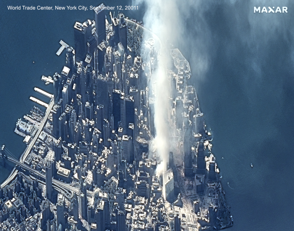
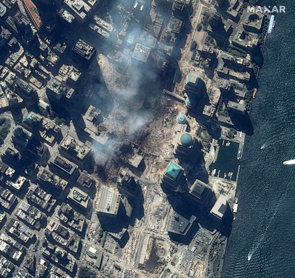
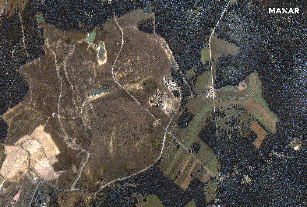
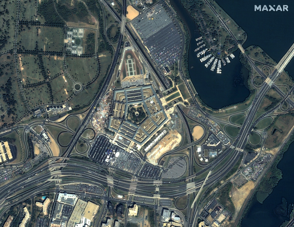
That morning, four commercial airplanes were hijacked: two crashed into the World Trade Center towers in New York City, one hit the Pentagon in Washington, D.C., and the passengers on the fourth plane forced it to crash in a field in Shanksville, Pennsylvania. Nearly 3,000 people died as result of these initial attacks.

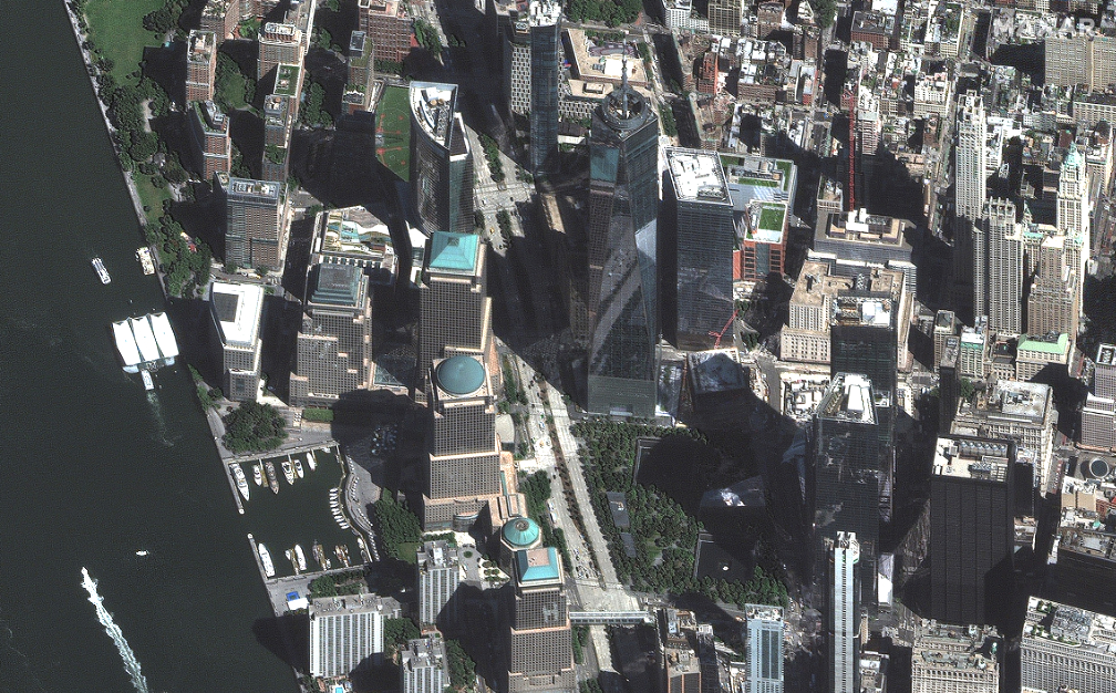
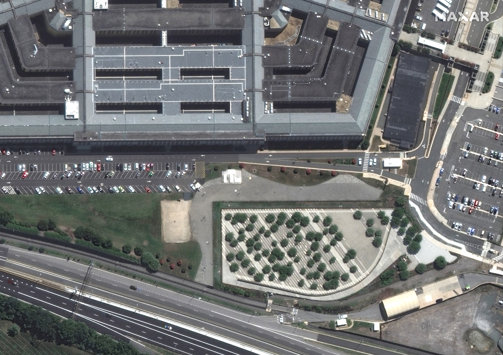
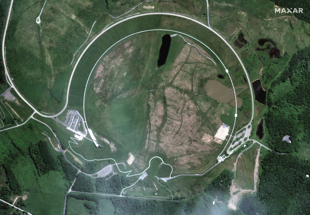
Maxar’s Satellite imagery of the 9/11 attack locations

As the devastation unfolded, Maxar’s Collection Planning Team shifted the tasking of IKONOS, the only high-resolution commercial satellite on orbit in 2001, to image the affected sites as quickly as possible. These were the first unclassified satellite images released to the public of the 9/11 attack locations.
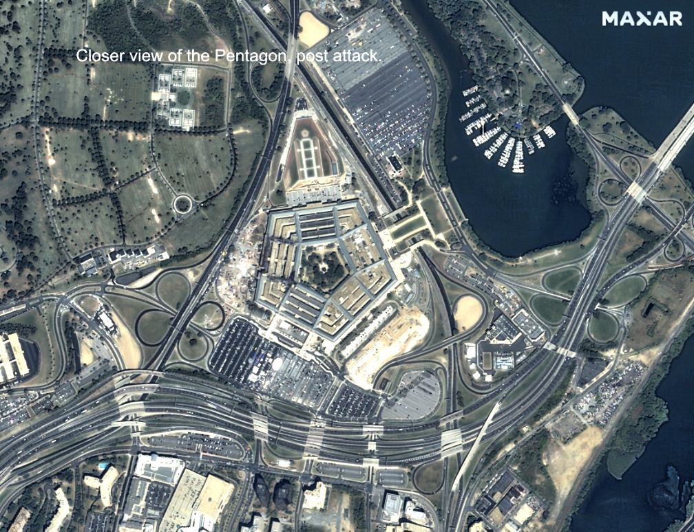
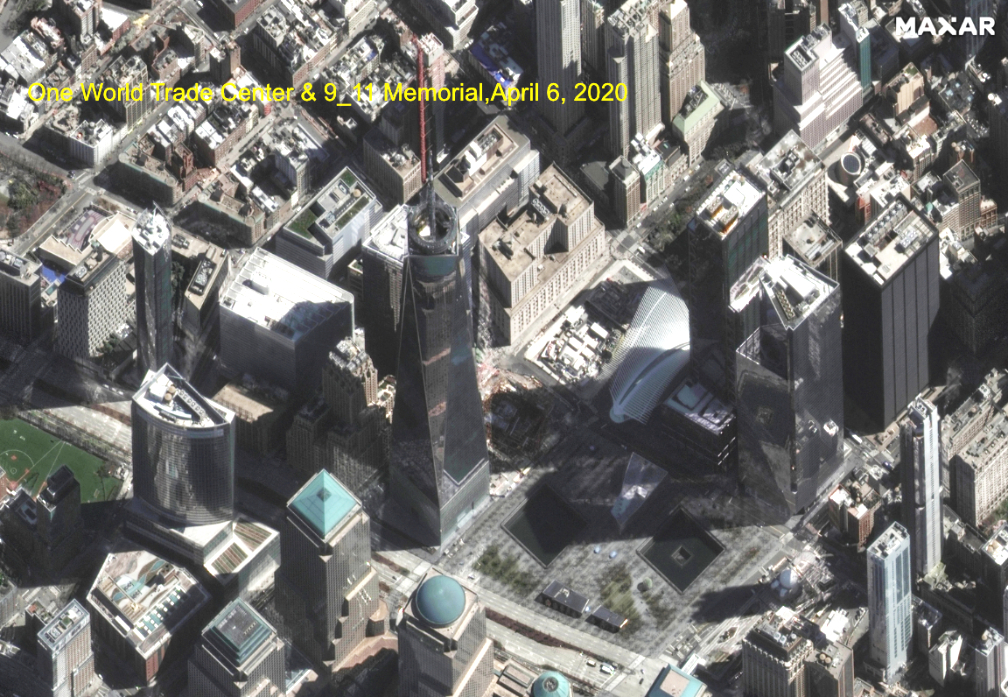
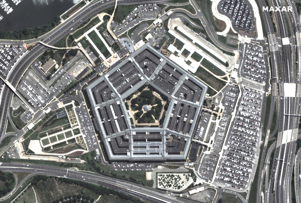
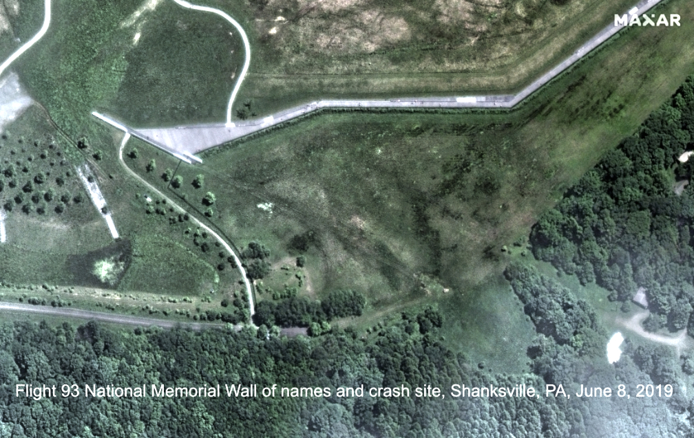
IKONOS collected this image of smoke rising above ground zero, where the Twin Towers collapsed in New York City on September 12, 2001.

The destruction at ground zero can be seen more clearly in this IKONOS image from September 15, 2001, when most of the smoke had dissipated.

IKONOS passed over Shanksville, Pennsylvania, on September 13, 2001, and collected this image that shows the site of the Flight 93 crash.

IKONOS imaged the Pentagon in Arlington, Virginia, on September 15, 2001. The affected area can be seen on the left side of the building.

The memorials…

Maxar satellite image capture of the Pentagon and the 9/11 Memorial, acquired in June of 2020.

Counter terrorism and the acceleration of commercial GEOINT

The 9/11 victims came from more than 80 nations. U.S. President George W. Bush stated, “It was an attack on the heart and soul of the civilized world.” Together, a coalition of nations initiated the War on Terror, with the goal of stopping the groups that orchestrated these and other attacks.

The War on Terror was the first major military campaign in history to leverage unclassified commercial satellite imagery for mission planning, monitoring and intelligence gathering. This foundational geospatial intelligence (GEOINT) enabled seamless intelligence sharing across U.S. combatant commands and with coalition partners.

The U.S. government began procuring commercial satellite imagery for foundational GEOINT in 2002 and continues to do so. These public-private partnerships have accelerated three significant GEOINT industry innovations:

More sophisticated spacecraft: Industry continues to launch increasingly capable Earth imaging satellites with higher resolutions, better accuracy, greater collection capacity, faster agility and more spectral bands.

Faster operational timelines: Methods for delivering space-based data to Earth have also evolved. Today, global ground station networks, mobile access terminals and the cloud all make it possible to rapidly collect, downlink, upload and disseminate commercial satellite data even in the most remote environments. The National Geospatial-Intelligence Agency’s Global Enhanced GEOINT Delivery platform puts the most recent imagery in the hands of U.S. government users within two hours of collection.

Augmented analysis: In the early 2000s, analysts would spend hundreds of hours manually searching through imagery. Now, with the industry-driven rise of artificial intelligence and machine learning, trained algorithms can perform the tedious task of locating the needles in the proverbial haystack, allowing analysts to dedicate more time to interpreting results and to deliver insight to decision-makers.

Geospecific training and the bin Laden raid

Commercial GEOINT also played a role in one of the most pivotal moments in the War on Terror—when the mastermind behind the 9/11 attacks, Osama bin Laden, was killed on May 2, 2011, by the U.S. Navy SEAL Team 6.

U.S. intelligence agencies tracked bin Laden to a compound in Abbottabad, Pakistan, and used Maxar imagery to study the structure of the compound in detail, allowing the military to simulate and train for the raid, enabling a precise operation once boots hit the ground. The Pakistani government demolished the compound in 2012. The site is now bare except for an old foundation.

20 years later

Significant rebuilding efforts have taken place at the 9/11 attack locations throughout the last two decades.

The site of the Twin Towers has been rebuilt as the 9/11 National Memorial and Museum. Construction on the new One World Trade Center tower was completed in 2014 and is now the tallest building in the Western Hemisphere.
The west side of the Pentagon was rebuilt with a year of the attacks, and the National 9/11 Pentagon Memorial was dedicated in 2008 to those who lost their lives.

The field where Flight 93 crashed in Shanksville, Pennsylvania, has become the Flight 93 National Memorial and is run by the National Park Service.

All imagery is ©Maxar Technologies.

Let us never forget!

Filed Under: Earth Observation & Imaging, Events & Conferences

Primary Sidebar

Coverage

  • Missions & Constellations
  • Business & Finance
  • Military & Defense
  • Launch
  • Software Automation & Ground Systems
  • Government & Regulation
  • Services & Applications

Most Read Stories

  • Planet Labs Imposes Indefinite Blackout on Iran Satellite Imagery at U.S. Request
  • What the SpaceX IPO Changes for Every Satellite Operator
  • Russia Replaces Starlink With European-Built Satellites
  • NASA Shuts Off Instrument on Voyager 1 to Extend Interstellar Mission
  • Space42 and Viasat: Contract close for 2800 satellites

Secondary Sidebar

Footer


Satnews is a leading provider of satellite news, events, publications, research and other satellite industry information in both commercial and military enterprises worldwide.

Stories By Category

  • Business & Finance
  • Government & Regulation
  • Launch
  • Military & Defense
  • Missions & Constellations
  • Services & Applications
  • Software Automation & Ground Systems
  • Spectrum & Licensing
  • Startups & NewSpace Business

About Us

  • Leadership & Editorial Team
  • SatNews History
  • Free Satnews Subscription
  • SatNews Events
  • Magazines

Navigation

  • Latest Stories
  • Magazines
  • Events
  • Contact
  • Cookie & Privacy Policy for Satnews

We use cookies to ensure that we give you the best experience on our website. If you continue to use this site we will assume that you are happy with it.
x
Sign up Now (For Free)
Access daily or weekly satellite news updates covering all aspects of the commercial and military satellite industry.
Invalid email address
Notify Me Regarding ( At least one ):
We value your privacy and will not sell or share your email or other information with any other company. You may also unsubscribe at anytime.

Click Here to see our full privacy policy.
Thanks for subscribing!