• Skip to primary navigation
  • Skip to main content
  • Skip to primary sidebar
  • Skip to secondary sidebar
  • Skip to footer
  • NEWS:
  • SatNews
  • SatMagazine
  • MilSatMagazine
  • SmallSat News
  • |     EVENTS:
  • SmallSat Symposium
  • Satellite Innovation
  • MilSat Symposium
  • SmallSat Europe

SatNews

Satellite Industry Intelligence Since 1983

Subscribe
  • LATEST
  • SatNews Events
  • Magazines
  • Calendar
  • Subscribe
  • Missions & Constellations
    • Exploration & Science Missions
    • In-Orbit Servicing & Orbital Operations
    • LEO Constellations
    • Mission Autonomy & Onboard Systems
    • Mission Deployments & Manifests
    • Navigation & PNT
    • SmallSat
    • Spacecraft & Payload Technology
    View All in Missions & Constellations →
    NASA and Boeing are facing prolonged Starliner uncertainty.NASA and Boeing are facing prolonged Starliner uncertainty.
    The Silent Overhaul: How Software-Defined Routing and Cloud Ingestion Flattened the Aerospace Hardware StackThe Silent Overhaul: How Software-Defined Routing and Cloud Ingestion Flattened the Aerospace Hardware Stack
    Hybrid Earth Intelligence: NASA Expands Commercial Satellite Data Integration in $476M Cloud-Driven PushHybrid Earth Intelligence: NASA Expands Commercial Satellite Data Integration in $476M Cloud-Driven Push
    Hybrid Edge Mobility: Contrivian Launches “Horizon Plus” to Deliver Intelligent Multi-Orbit Field CommunicationsHybrid Edge Mobility: Contrivian Launches “Horizon Plus” to Deliver Intelligent Multi-Orbit Field Communications
  • Business
    • Contracts & Commercial Deals
    • Earnings & Financial Reporting
    • Events & Conferences
    • Funding & Venture Capital
    • Market Forecasts
    • Mergers & Acquisitions
    • Personnel Moves & Appointments
    View All in Business & Finance →
    The Spatial Photonics Crunch: Inside the Invisible Supply Chain Threatening Orbital Laser NetworksThe Spatial Photonics Crunch: Inside the Invisible Supply Chain Threatening Orbital Laser Networks
    Sovereign Space Expansion: Spain’s FOSSA Systems Secures €9.25M to Scale Defense Constellation and SIGINT InfrastructureSovereign Space Expansion: Spain’s FOSSA Systems Secures €9.25M to Scale Defense Constellation and SIGINT Infrastructure
    Next-Gen Spatial Intelligence: BAE Systems Secures Agreement to Build High-Resolution Vantage Satellite Buses for VantorNext-Gen Spatial Intelligence: BAE Systems Secures Agreement to Build High-Resolution Vantage Satellite Buses for Vantor
    New Lobbying Force: Top NGSO Operators Unveil “SpaceConnect Association” in WashingtonNew Lobbying Force: Top NGSO Operators Unveil “SpaceConnect Association” in Washington
  • Defense
    • Counterspace & ASAT
    • Defense Budgets & Procurement
    • ISR & Reconnaissance
    • MILSATCOM
    • Missile Warning & Defense
    • National Security Programs
    • Space Domain Awareness
    View All in Military & Defense →
    Digital Twins for Space Command: Sedaro Tapped by Space Force to Build Federated Engineering PlatformDigital Twins for Space Command: Sedaro Tapped by Space Force to Build Federated Engineering Platform
    The Strategic Redistribution of Iranian Aerospace CapabilityThe Strategic Redistribution of Iranian Aerospace Capability
    Navigating Contested Battlespaces: Military GPS Receiver Market Approaches $3 Billion Amid Electronic Warfare SurgeNavigating Contested Battlespaces: Military GPS Receiver Market Approaches $3 Billion Amid Electronic Warfare Surge
    Preparing for Day One: DARPA Solicits Tech to Rebuild Destroyed Satellite Fleets Within HoursPreparing for Day One: DARPA Solicits Tech to Rebuild Destroyed Satellite Fleets Within Hours
  • Gov
    • Export Controls & Compliance
    • International Space Agreements
    • National Space Policy
    • Space Law & Treaties
    • Space Sustainability & Debris Policy
    • Space Traffic Management / Debris Removal
    View All in Government & Regulation →
    Clearing C-band “will be expensive” says SESClearing C-band “will be expensive” says SES
    $3.57 Billion Milestone: FCC Advanced Wireless Services (AWS-3) Spectrum Auction Concludes$3.57 Billion Milestone: FCC Advanced Wireless Services (AWS-3) Spectrum Auction Concludes
    Who Has Authority to Intervene in a Space-Based Emergency?Who Has Authority to Intervene in a Space-Based Emergency?
    Staying in Their Lanes: SpaceX and Globalstar Join Forces to Defend Spectrum ExclusivityStaying in Their Lanes: SpaceX and Globalstar Join Forces to Defend Spectrum Exclusivity
  • Launch
    • Launch Providers
    • Launch Schedule & Calendars
    • Launch Sites & Infrastructure
    • Rocket Technology & Vehicles
    View All in Launch →
    Arianespace fights back – possibly!Arianespace fights back – possibly!
    Direct-to-Device Momentum: AST SpaceMobile Successfully Launches Giant Next-Gen BlueBird Satellites Atop SpaceX Falcon 9Direct-to-Device Momentum: AST SpaceMobile Successfully Launches Giant Next-Gen BlueBird Satellites Atop SpaceX Falcon 9
    SpaceX’s Secret ‘Starfall’ Capsule Wins FAA Approval for Pacific Reentry TestsSpaceX’s Secret ‘Starfall’ Capsule Wins FAA Approval for Pacific Reentry Tests
    Breaking the TRL Bottleneck: Space Phoenix Systems Debuts Cost-Effective Space Test-and-Return ServiceBreaking the TRL Bottleneck: Space Phoenix Systems Debuts Cost-Effective Space Test-and-Return Service
  • Software
    • Autonomous Ground Operations
    • Data Processing & AI/ML
    • Digital Twins & Modeling
    • Ground Segment & Teleports
    • Mission Planning & Simulation
    • Space Systems Software Engineering
    • Spectrum & Licensing
    View All in Software Automation & Ground Systems →
    Powering the Automated Floor: Intralogistics Operators Must Unify AGV Charging InfrastructurePowering the Automated Floor: Intralogistics Operators Must Unify AGV Charging Infrastructure
    Poland Sovereignty: GMV to Develop Core Ground Control Platform for CAMILA ConstellationPoland Sovereignty: GMV to Develop Core Ground Control Platform for CAMILA Constellation
    Software Over the Air: FatPipe Launches Acceleration Tool to Unclog Starlink and Amazon LEO LinksSoftware Over the Air: FatPipe Launches Acceleration Tool to Unclog Starlink and Amazon LEO Links
    Three LEO Operators Bet 2026 on a Supply Chain Built for 2027Three LEO Operators Bet 2026 on a Supply Chain Built for 2027
  • Services & Apps
    • Climate & Environmental Monitoring
    • Disaster Response & Security Mapping
    • Earth Observation & Imaging
    • Maritime & Aviation Satcom
    • Satellite Communications
    View All in Services & Applications →
    National SAR Defense: Norway Selects ICEYE for Nationwide Space-Based Flood and Hazard Monitoring SystemNational SAR Defense: Norway Selects ICEYE for Nationwide Space-Based Flood and Hazard Monitoring System
    Sovereign Milestone: OQ Technology Achieves Europe’s First Drone Video Transmission via 3GPP NTN LEO SatelliteSovereign Milestone: OQ Technology Achieves Europe’s First Drone Video Transmission via 3GPP NTN LEO Satellite
    Ghost Viewers trigger secondary ripple effect on Satellite Communications (SatCom)Ghost Viewers trigger secondary ripple effect on Satellite Communications (SatCom)
    Fleet-Wide Hybrid Networks: Marlink Integrates Starlink Across 80+ Oldendorff Carriers VesselsFleet-Wide Hybrid Networks: Marlink Integrates Starlink Across 80+ Oldendorff Carriers Vessels

Here’s Looking @ Earth… A Grand Landsat View… (Imagery)

April 22, 2013


Satellite image by Robert Simmon, using Landsat data from the U.S. Geological Survey and NASA.
Caption by Adam Voiland.
[SatNews] When John Wesley Powell led an expedition down the Colorado River and through the Grand Canyon in…

…1869, he was confronted with a daunting landscape. At its highest point, the serpentine gorge plunged 2,400 meters (8,000 feet) from rim to river bottom, making it the deepest canyon in the United States. In just 6 million years, water had carved through rock layers that collectively represented more than 2 billion years of geological history, nearly half of the time Earth has existed.

“The wonders of the Grand Canyon cannot be adequately represented in symbols or speech,” Powell wrote in his log. “The resources of the graphic art are taxed beyond their powers in attempting to portray its features.”

Powell was, of course, seeing the canyon mainly from river level; there was no technology that provided views of the landscape from space then. If there had been, he would have seen something similar to what the Operational Land Imager (OLI) on the Landsat Data Continuity Mission (LDCM) did on March 29, 2013. LDCM is an Earth-observing satellite that launched from Vandenberg Air Force Base in February 2013.

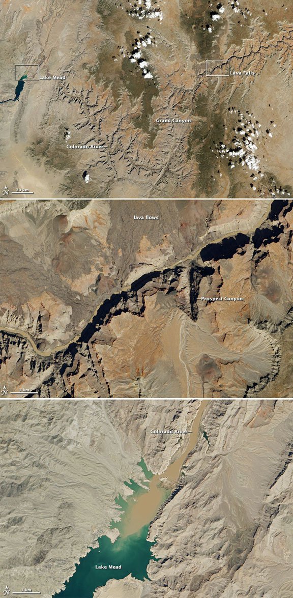
In the image above (top), the Colorado River traces a line across the arid Colorado Plateau. Treeless areas are beige and orange; green areas are forested. The river water is brown and muddy, a common occurrence in spring when melting snows cause water levels to swell and pick up extra sediment. The black line that follows the river in the upper right side of the image is comprised of shadows.

One of the geological features that attracted Powell’s attention was a set of rapids at mile 183 of the canyon. Powell called the rapids Lava Falls (middle image), a reference to old lava flows that spilled from the Uinkaret Volcanic Field just north of the river. When lava flowed into the river, it left dams that were hundreds of meters high in some cases. These dams blocked the river and created huge reservoirs until the Colorado found ways around them. “Just imagine a river of molten rock running down into a river of melted snow. What a seething and boiling of the waters; what clouds of steam rolled into the heavens,” Powell wrote of Lava Falls.

Due to its name, many assume that the rapids at Lava Falls are caused by debris from lava flows that entered the river from the north. In fact, material from periodic landslides from Prospect Canyon to the south are the main source of debris, according to research conducted by U.S. Geological Survey scientists.

It took Powell months to navigate the gorge. By the time he had arrived in the area that is now Lake Mead, his men were weary and four had deserted. For water and sediment transported by the Colorado, the journey is much quicker; it takes just a handful of days. The flow of sediment into Lake Mead (bottom image) from the Colorado deposits a thick layer of material on the bottom of the reservoir. At the mouth of the Colorado, the area that has seen the most accumulation, sonar studies have shown that sediment thickness exceeds 80 meters (262 feet).

Note that this image is considered engineering data—data that is helping scientists and engineers ensure that the satellite and its instruments are operating as designed. Once LDCM completes its check-out period and becomes fully operational for science, NASA will pass control of the satellite to the U.S. Geological Survey and LDCM will be re-named Landsat 8.

Filed Under: Earth Observation & Imaging

Primary Sidebar

Coverage

  • Missions & Constellations
  • Business & Finance
  • Military & Defense
  • Launch
  • Software Automation & Ground Systems
  • Government & Regulation
  • Services & Applications

Most Read Stories

  • SpaceX’s Secret ‘Starfall’ Capsule Wins FAA Approval for Pacific Reentry Tests
  • American military space closed around one company in seven days
  • Analyst Projects Massive Subscription Growth for Starlink Ahead of Imminent SpaceX IPO
  • Major opportunities for 2 GHz over Europe
  • Amazon Leo Constellation Surpasses 330 Satellites Following Latest Atlas V Launch

Secondary Sidebar

Footer


Satnews is a leading provider of satellite news, events, publications, research and other satellite industry information in both commercial and military enterprises worldwide.

Stories By Category

  • Business & Finance
  • Government & Regulation
  • Launch
  • Military & Defense
  • Missions & Constellations
  • Services & Applications
  • Software Automation & Ground Systems
  • Spectrum & Licensing
  • Startups & NewSpace Business

About Us

  • Leadership & Editorial Team
  • SatNews History
  • Free Satnews Subscription
  • SatNews Events
  • Magazines

Navigation

  • Latest Stories
  • Magazines
  • Events
  • Contact
  • Cookie & Privacy Policy for Satnews

We use cookies to ensure that we give you the best experience on our website. If you continue to use this site we will assume that you are happy with it.
x
Sign up Now (For Free)
Access daily or weekly satellite news updates covering all aspects of the commercial and military satellite industry.
Invalid email address
Notify Me Regarding ( At least one ):
We value your privacy and will not sell or share your email or other information with any other company. You may also unsubscribe at anytime.

Click Here to see our full privacy policy.
Thanks for subscribing!