• Skip to primary navigation
  • Skip to main content
  • Skip to primary sidebar
  • Skip to secondary sidebar
  • Skip to footer
  • NEWS:
  • SatNews
  • SatMagazine
  • MilSatMagazine
  • SmallSat News
  • |     EVENTS:
  • SmallSat Symposium
  • Satellite Innovation
  • MilSat Symposium
  • SmallSat Europe

SatNews

Satellite Industry Intelligence Since 1983

Subscribe
  • LATEST
  • SatNews Events
  • Magazines
  • Calendar
  • Subscribe
  • Missions & Constellations
    • Exploration & Science Missions
    • In-Orbit Servicing & Orbital Operations
    • LEO Constellations
    • Mission Autonomy & Onboard Systems
    • Mission Deployments & Manifests
    • Navigation & PNT
    • SmallSat
    • Spacecraft & Payload Technology
    View All in Missions & Constellations →
    SpaceX’s Secret ‘Starfall’ Capsule Wins FAA Approval for Pacific Reentry TestsSpaceX’s Secret ‘Starfall’ Capsule Wins FAA Approval for Pacific Reentry Tests
    NOAA Activates First Dedicated U.S. Space Weather Satellite One Million Miles from EarthNOAA Activates First Dedicated U.S. Space Weather Satellite One Million Miles from Earth
    Thales Alenia Space to coordinate EROSS SC On-Orbit Servicing projectThales Alenia Space to coordinate EROSS SC On-Orbit Servicing project
    Astroscale Launches Industry Initiative to Study Atmospheric Impact of Spacecraft ReentryAstroscale Launches Industry Initiative to Study Atmospheric Impact of Spacecraft Reentry
  • Business
    • Contracts & Commercial Deals
    • Earnings & Financial Reporting
    • Events & Conferences
    • Funding & Venture Capital
    • Market Forecasts
    • Mergers & Acquisitions
    • Personnel Moves & Appointments
    View All in Business & Finance →
    SOMA Satellite Factory: Planet Labs Expands San Francisco HQ to Supercharge Production PipelineSOMA Satellite Factory: Planet Labs Expands San Francisco HQ to Supercharge Production Pipeline
    Riding the Starship: The SpaceX IPO Is Set to Rocket Seattle’s Aerospace EcosystemRiding the Starship: The SpaceX IPO Is Set to Rocket Seattle’s Aerospace Ecosystem
    Space Race Moves to Wall Street: China’s Private Rocket Makers Target IPOs as Historic SpaceX Flotation NearsSpace Race Moves to Wall Street: China’s Private Rocket Makers Target IPOs as Historic SpaceX Flotation Nears
    Behind the Screens: The Massive Video Over-IP Infrastructure Powering the World CupBehind the Screens: The Massive Video Over-IP Infrastructure Powering the World Cup
  • Defense
    • Counterspace & ASAT
    • Defense Budgets & Procurement
    • ISR & Reconnaissance
    • MILSATCOM
    • Missile Warning & Defense
    • National Security Programs
    • Space Domain Awareness
    View All in Military & Defense →
    Space-Based Shield: Spire Global and Diehl Defence Partner to Build European Missile Warning NetworkSpace-Based Shield: Spire Global and Diehl Defence Partner to Build European Missile Warning Network
    Qorvo Unveils Compact X-Band Radar Module to Enhance Defense System PerformanceQorvo Unveils Compact X-Band Radar Module to Enhance Defense System Performance
    Energration and Atombeam Partner on DARPA Proposal to Revolutionize Tactical Data Movement at the Defense EdgeEnergration and Atombeam Partner on DARPA Proposal to Revolutionize Tactical Data Movement at the Defense Edge
    American military space closed around one company in seven daysAmerican military space closed around one company in seven days
  • Gov
    • Export Controls & Compliance
    • International Space Agreements
    • National Space Policy
    • Space Law & Treaties
    • Space Sustainability & Debris Policy
    • Space Traffic Management / Debris Removal
    View All in Government & Regulation →
    Major opportunities for 2 GHz over EuropeMajor opportunities for 2 GHz over Europe
    “Dual-use” is the funding word. It’s also the label operators want off.“Dual-use” is the funding word. It’s also the label operators want off.
    Sovereignty got an answer on Day 3. Two answers, actually, and a commercial veto.Sovereignty got an answer on Day 3. Two answers, actually, and a commercial veto.
    Dependency killed the old debate. Sovereignty is the new one, and Europe hasn’t agreed what it means.Dependency killed the old debate. Sovereignty is the new one, and Europe hasn’t agreed what it means.
  • Launch
    • Launch Providers
    • Launch Schedule & Calendars
    • Launch Sites & Infrastructure
    • Rocket Technology & Vehicles
    View All in Launch →
    Breaking the TRL Bottleneck: Space Phoenix Systems Debuts Cost-Effective Space Test-and-Return ServiceBreaking the TRL Bottleneck: Space Phoenix Systems Debuts Cost-Effective Space Test-and-Return Service
    Twelve Scientific Payloads Experience Microgravity Aboard SubOrbital Express-5Twelve Scientific Payloads Experience Microgravity Aboard SubOrbital Express-5
    Amazon Leo Constellation Surpasses 330 Satellites Following Latest Atlas V LaunchAmazon Leo Constellation Surpasses 330 Satellites Following Latest Atlas V Launch
    If You Thought Space Was Hard Try to Get Your Satellite On a RocketIf You Thought Space Was Hard Try to Get Your Satellite On a Rocket
  • Software
    • Autonomous Ground Operations
    • Data Processing & AI/ML
    • Digital Twins & Modeling
    • Ground Segment & Teleports
    • Mission Planning & Simulation
    • Space Systems Software Engineering
    • Spectrum & Licensing
    View All in Software Automation & Ground Systems →
    Software Over the Air: FatPipe Launches Acceleration Tool to Unclog Starlink and Amazon LEO LinksSoftware Over the Air: FatPipe Launches Acceleration Tool to Unclog Starlink and Amazon LEO Links
    Three LEO Operators Bet 2026 on a Supply Chain Built for 2027Three LEO Operators Bet 2026 on a Supply Chain Built for 2027
    NASA Advances Interoperable Space Networks with Successful PExT DemonstrationNASA Advances Interoperable Space Networks with Successful PExT Demonstration
    KSAT and iQPS Expand Strategic Alliance to Accelerate High-Frequency SAR ConstellationKSAT and iQPS Expand Strategic Alliance to Accelerate High-Frequency SAR Constellation
  • Services & Apps
    • Climate & Environmental Monitoring
    • Disaster Response & Security Mapping
    • Earth Observation & Imaging
    • Maritime & Aviation Satcom
    • Satellite Communications
    View All in Services & Applications →
    Eutelsat and Tototheo Global Forge Partnership to Deliver LEO Connectivity Across Maritime and Government SectorsEutelsat and Tototheo Global Forge Partnership to Deliver LEO Connectivity Across Maritime and Government Sectors
    Marlink Equips Groupama-FDJ Cycling Team with Hybrid Starlink and LTE NetworkMarlink Equips Groupama-FDJ Cycling Team with Hybrid Starlink and LTE Network
    Viasat Secures Lockheed Martin Contract for NOAA’s Next-Generation AircraftViasat Secures Lockheed Martin Contract for NOAA’s Next-Generation Aircraft
    SES Partners with Viva to Launch Multi-Orbit In-Flight ConnectivitySES Partners with Viva to Launch Multi-Orbit In-Flight Connectivity

Here’s Looking @ Earth… Irene Is Now A Major Blow (Imagery)

August 24, 2011

[SatNews] Irene has become a major hurricane…

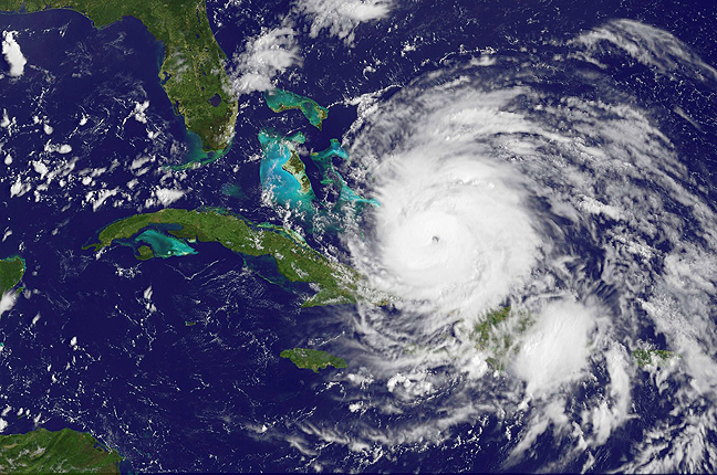
When a satellite can see a hurricane’s eye clearly from space, that’s an indication of a strong tropical cyclone. The GOES-13 satellite saw just that in Hurricane Irene this morning, as she became a major hurricane. An animation of GOES-13 satellite imagery released from NASA today shows Irene’s transition into a powerhouse and pinpointed when her eye became visible from space. To view the animation, select this direct link. Hurricane Irene reached Category 3 status this morning, the threshold for a major hurricane on the Saffir-Simpson scale that measures hurricane intensity.


Text Credit: Rob Gutro, NASA’s Goddard Space Flight Center, Greenbelt, Md.


The Geostationary Operational Environmental Satellite called GOES-13 provides continuous visible and infrared imagery of the eastern U.S. and Atlantic Ocean basin from its position in space. GOES satellites are operated by NOAA, and the NASA GOES Project located at NASA’s Goddard Space Flight Center in Greenbelt, Md. creates images and compiled them into the video of the storm as it developed from June 27 to June 28. The animation includes sped up infrared and visible frames of data from the GOES-13 satellite and is squeezed down to 36 seconds. The movie shows satellite imagery that was captured in 15 minute intervals from August 22 at 8:40 a.m. EDT (1240 UTC) until August 24 at 8:40 a.m. EDT shows Irene moving over Puerto Rico, Hispaniola and toward the southeastern Bahamas. Irene’s eye becomes visible on August 24 at 0055 UTC (Aug. 23 at 8:55 p.m. EDT).

Irene became a major hurricane at 8:00 a.m. EDT today, August 24, 2011, as it headed toward the Crooked and Acklins Islands in the Bahamas. Irene’s maximum sustained winds had increased to 115 mph (186 kmh) making Category three status. Additional strengthening is forecast by the National Hurricane Center (NHC). Category three hurricanes can cause “devastating damage” according to the NHC’s webpage: https://www.nhc.noaa.gov/sshws.shtml.


Artist’s conception of the GOES-13 satellite. Credit: NASA
As of this writing, Irene is located about 55 miles southeast of Acklins Island, Bahamas, near 21.9 North and 73.3 West. It was moving to the west-northwest at 9 mph (15 kmh) and had a minimum central pressure near 957 millibars. A hurricane warning is in effect for the southeastern, central and northwestern Bahamas, and a tropical storm warning is in effect for the Turks and Caicos Islands. An unofficial reporting station at Pine Cay, located in the Caicos Islands reported a wind gust to 65 mph (105 kmh) earlier today.

Rainfall amount across Hispaniola and Puerto Rico will be between 1 and 3 inches as Irene pushes away. However, isolated maximum storm total amounts of 15 inches are possible with flash floods and mud slides in areas of steep terrain. In the Bahamas, Turks and Caicos islands high rainfall totals are forecast by NHC of between 6 to 12 inches are expected. The NHC warns that “an extremely dangerous storm surge will raise water levels by as much as 7 to 11 feet above normal tide levels over the central and northwestern Bahamas and by as much as 5 to 8 feet above normal tide levels over the southeastern Bahamas and the Turks and Caicos islands.”

Hurricane Irene is a large storm that has continued to grow over the last several days as it has strengthened. Tropical storm-force winds extend out to 205 miles from its center, making Irene about 410 miles in diameter! Hurricane force-winds extend out to 40 miles, or 80 miles in diameter. The NHC’s current forecast track for Hurricane Irene takes the storm to a landfall in eastern North Carolina as a major hurricane on Saturday, August 27. The NASA GOES Project will continue to provide imagery and animations from the GOES-13 satellite daily as Irene nears the U.S.

Filed Under: Disaster Response & Security Mapping, Earth Observation & Imaging

Primary Sidebar

Coverage

  • Missions & Constellations
  • Business & Finance
  • Military & Defense
  • Launch
  • Software Automation & Ground Systems
  • Government & Regulation
  • Services & Applications

Most Read Stories

  • SpaceX Debuts Starship V3: Redefining Heavy-Lift Launch Capability
  • SpaceX Is Worth $1.75 Trillion. Only 7% of That Is Real.
  • SpaceX: 10,000 Launches Annually
  • American military space closed around one company in seven days
  • The end of GEO?

Secondary Sidebar

Footer


Satnews is a leading provider of satellite news, events, publications, research and other satellite industry information in both commercial and military enterprises worldwide.

Stories By Category

  • Business & Finance
  • Government & Regulation
  • Launch
  • Military & Defense
  • Missions & Constellations
  • Services & Applications
  • Software Automation & Ground Systems
  • Spectrum & Licensing
  • Startups & NewSpace Business

About Us

  • Leadership & Editorial Team
  • SatNews History
  • Free Satnews Subscription
  • SatNews Events
  • Magazines

Navigation

  • Latest Stories
  • Magazines
  • Events
  • Contact
  • Cookie & Privacy Policy for Satnews

We use cookies to ensure that we give you the best experience on our website. If you continue to use this site we will assume that you are happy with it.
x
Sign up Now (For Free)
Access daily or weekly satellite news updates covering all aspects of the commercial and military satellite industry.
Invalid email address
Notify Me Regarding ( At least one ):
We value your privacy and will not sell or share your email or other information with any other company. You may also unsubscribe at anytime.

Click Here to see our full privacy policy.
Thanks for subscribing!