
LISBON, PORTUGAL — June 25, 2026 — Confronting a silent, accelerating ecological invasion along the Atlantic shoreline, technology multinational GMV has partnered with the Municipality of Cascais and the Plymouth Marine Laboratory to launch a space-based predictive defense system.

The initiative aims to track, map, and anticipate the coastal movements of Rugulopteryx okamurae, an aggressive brown seaweed native to the Pacific waters of Asia that is currently destabilizing marine ecosystems across Western Europe.
Funded directly by the Cascais local government, the 12-month program is designated as EO4RO (Earth Observation for the Mapping and Monitoring of Rugulopteryx okamurae). The joint venture marks a shift from reactive, land-based beach cleanup operations to a predictive, space-to-ocean early warning framework.
Overturning a Reactive Environmental Crisis
First detected in the Mediterranean Sea in 2002, Rugulopteryx okamurae has adapted aggressively to Atlantic currents. In recent years, the invasive macroalgae has blanketed European coastal zones with thick, decomposing mats of organic material. The environmental and economic fallout has been severe, driving up municipal beach maintenance budgets, degrading protected underwater habitats, entangling commercial fishing nets, and disrupting local tourism economies.
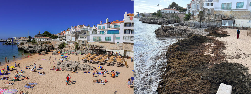
Historically, coastal management teams have operated blindly, deploying cleanup crews only after tons of seaweed wash ashore. The EO4RO platform alters this dynamic by transforming data from European orbital assets into predictive, actionable models.
The Predictive Modeling Stack
The technical architecture merges multi-spectral satellite imagery with real-time marine analytics, routing data through automated AI processing pipelines to deliver predictive foresight:
- Near Real-Time Extent Mapping: Processing spectral signatures from orbit to pinpoint the exact perimeter of offshore algae blooms.
- Hydrodynamic Drift Simulations: Fusing ocean current velocity, sea surface heights, and local wind stress models to track and forecast the drift velocity of the seaweed biomass.
- Benthic Habitat Vulnerability Mapping: Generating structural underwater charts to isolate and defend local native marine sanctuaries most susceptible to smothering.
- Automated Threat Dissemination: Triggering push alerts to local port authorities, civil protection units, and commercial fisheries well ahead of land impact.
The technical playbook builds directly upon analytical architectures originally engineered by GMV and PML to model maritime oil spills, intercept illegal waste discharges, and track severe oceanographic anomalies.
Scaling Sovereign Space Solutions
GMV brings deep European Space Agency (ESA) and institutional pedigree to the consortium. The multinational technology group is a foundational player within the European Union’s Copernicus Earth Observation programme, responsible for the development, operational logic, and end-to-end mission planning software networks for the Sentinel-1, Sentinel-2, Sentinel-3, Sentinel-6, and upcoming CO2M satellite series.
Concurrently, the Plymouth Marine Laboratory provides the oceanographic baseline data, translating orbital radiometer and synthetic aperture radar (SAR) returns into highly specific biological metrics.
“This collaboration demonstrates the potential of cooperation between science, technology, and local government to address emerging environmental challenges. Cascais is committed to remaining at the forefront of innovation applied to the protection and sustainable management of coastal areas,” noted Nuno Piteira Lopes, Mayor of Cascais.
Establishing a European Benchmark
If the initial 12-month pilot project across the Cascais coast meets validation targets, the municipality will serve as the premier operational case study for algorithmic, smart coastal defense infrastructure in Europe. Given that Rugulopteryx okamurae continues to march northward and southward unchecked, the unified EO4RO software model is designed to be highly replicable, offering an identical plug-and-play monitoring architecture for vulnerable shorelines extending from the North Atlantic and the Mediterranean down to the Algarve and the Canary Islands.
Filipe Brandão, Senior Project Manager at GMV in Portugal, emphasized that the deployment underscores the true societal value of advanced space systems:
“We are applying technologies developed to address global challenges to a very specific problem affecting beaches, ecosystems, and local economies,” Brandão stated. “If we manage to predict the problem before it occurs, we will save time, reduce public expenditure and improve environmental protection. That is the true potential of this project.“