

• Skip to primary navigation
  • Skip to main content
  • Skip to primary sidebar
  • Skip to secondary sidebar
  • Skip to footer
  • NEWS:
  • SatNews
  • SatMagazine
  • MilSatMagazine
  • SmallSat News
  • |     EVENTS:
  • SmallSat Symposium
  • Satellite Innovation
  • MilSat Symposium
  • SmallSat Europe

SatNews

Satellite Industry Intelligence Since 1983

Subscribe
  • LATEST
  • SatNews Events
  • Magazines
  • Calendar
  • Subscribe
  • Missions & Constellations
    • Exploration & Science Missions
    • In-Orbit Servicing & Orbital Operations
    • LEO Constellations
    • Mission Autonomy & Onboard Systems
    • Mission Deployments & Manifests
    • Navigation & PNT
    • SmallSat
    • Spacecraft & Payload Technology
    View All in Missions & Constellations →
    Russia Files ITU Plan for 374-Satellite Rassvet-4 Constellation Following Rassvet-3 Orbital SetbacksRussia Files ITU Plan for 374-Satellite Rassvet-4 Constellation Following Rassvet-3 Orbital Setbacks
    Space Data Centers Face a Semiconductor ChallengeSpace Data Centers Face a Semiconductor Challenge
    Space Industries Inaugurates €20M Stellar Hub in Italy for Serial Satellite ProductionSpace Industries Inaugurates €20M Stellar Hub in Italy for Serial Satellite Production
    Amazon Navigates Launch Delays with Under 400 Satellites in Orbit Ahead of Nov. 13 Vulcan ReturnAmazon Navigates Launch Delays with Under 400 Satellites in Orbit Ahead of Nov. 13 Vulcan Return
  • Business
    • Contracts & Commercial Deals
    • Earnings & Financial Reporting
    • Events & Conferences
    • Funding & Venture Capital
    • Market Forecasts
    • Mergers & Acquisitions
    • Personnel Moves & Appointments
    View All in Business & Finance →
    SpaceX Explores Boost Mobile Acquisition in Push to Build Hybrid Terrestrial-Satellite NetworkSpaceX Explores Boost Mobile Acquisition in Push to Build Hybrid Terrestrial-Satellite Network
    MDA Space Secures C$100M+ Thales Alenia Space Award for First 66 IRIS² SatellitesMDA Space Secures C$100M+ Thales Alenia Space Award for First 66 IRIS² Satellites
    Northwood Space Secures $375M Series C at $2B Valuation to Expand Shared Ground Station NetworkNorthwood Space Secures $375M Series C at $2B Valuation to Expand Shared Ground Station Network
    Eutelsat Q1 LEO Revenue Rises 30% to €70.9M as OneWeb Offsets Video DeclineEutelsat Q1 LEO Revenue Rises 30% to €70.9M as OneWeb Offsets Video Decline
  • Defense
    • Counterspace & ASAT
    • Defense Budgets & Procurement
    • ISR & Reconnaissance
    • MILSATCOM
    • Missile Warning & Defense
    • National Security Programs
    • Space Domain Awareness
    View All in Military & Defense →
    ThinKom and Space Systems Command Demonstrate GECKO Multi-Orbit Containerized SATCOM SystemThinKom and Space Systems Command Demonstrate GECKO Multi-Orbit Containerized SATCOM System
    Vantor Cuts Satellite Imagery Delivery Time to Seven Minutes in Ukrainian Field DemonstrationVantor Cuts Satellite Imagery Delivery Time to Seven Minutes in Ukrainian Field Demonstration
    L3Harris Secures $36M Army SATCOM Order for Hawkeye 4 Lite Terminals Supporting C2NOWL3Harris Secures $36M Army SATCOM Order for Hawkeye 4 Lite Terminals Supporting C2NOW
    Space Force Awards Lockheed Martin $95M GPS IIIF Modification, Bringing Contract Face Value to $4.73BSpace Force Awards Lockheed Martin $95M GPS IIIF Modification, Bringing Contract Face Value to $4.73B
  • Gov
    • Export Controls & Compliance
    • International Space Agreements
    • National Space Policy
    • Space Law & Treaties
    • Space Sustainability & Debris Policy
    • Space Traffic Management / Debris Removal
    View All in Government & Regulation →
    FCC Proposes 25 MHz Mid-Band Spectrum Auction with Dual 5G and Direct-to-Device AllocationsFCC Proposes 25 MHz Mid-Band Spectrum Auction with Dual 5G and Direct-to-Device Allocations
    Part 100 Puts FCC Satellite Licensing on an Assembly LinePart 100 Puts FCC Satellite Licensing on an Assembly Line
    FCC Proposes Modernized Direct-to-Device Rules, Explores 482 MHz Expansion for Satellite CellularFCC Proposes Modernized Direct-to-Device Rules, Explores 482 MHz Expansion for Satellite Cellular
    Canada’s Satellite-to-Phone Network Can’t Go It Alone, So Terrestar Joined EquatysCanada’s Satellite-to-Phone Network Can’t Go It Alone, So Terrestar Joined Equatys
  • Launch
    • Launch Providers
    • Launch Schedule & Calendars
    • Launch Sites & Infrastructure
    • Rocket Technology & Vehicles
    View All in Launch →
    NASA Outlines Artemis IV Starship Refueling Architecture as Launch Estimates VaryNASA Outlines Artemis IV Starship Refueling Architecture as Launch Estimates Vary
    HIMERA and GomSpace Begin Orbital Operations of OBRIA NANO Test Satellite for Sovereign Ukrainian NetworkHIMERA and GomSpace Begin Orbital Operations of OBRIA NANO Test Satellite for Sovereign Ukrainian Network
    Blue Origin Reconstructs Launch Complex 36 Tower, Targets November Return to Flight for New GlennBlue Origin Reconstructs Launch Complex 36 Tower, Targets November Return to Flight for New Glenn
    DIA Space Security Report Reveals Detailed Orbital Imagery of China’s Shenlong SpaceplaneDIA Space Security Report Reveals Detailed Orbital Imagery of China’s Shenlong Spaceplane
  • Software
    • Autonomous Ground Operations
    • Data Processing & AI/ML
    • Digital Twins & Modeling
    • Ground Segment & Teleports
    • Mission Planning & Simulation
    • Space Systems Software Engineering
    • Spectrum & Licensing
    View All in Software Automation & Ground Systems →
    MBSat Selects ST Engineering iDirect Intuition Platform for Ground Infrastructure in OmanMBSat Selects ST Engineering iDirect Intuition Platform for Ground Infrastructure in Oman
    AnySignal Co-Founder Urges Ground Station Interoperability to Resolve Orbital Data BottlenecksAnySignal Co-Founder Urges Ground Station Interoperability to Resolve Orbital Data Bottlenecks
    Arqiva Secures Three-Year Satellite Services Agreement with Kuwait’s GulfsatArqiva Secures Three-Year Satellite Services Agreement with Kuwait’s Gulfsat
    TrustPoint and Calian Deliver Industry’s First Mass-Market Ready C-band GNSS AntennaTrustPoint and Calian Deliver Industry’s First Mass-Market Ready C-band GNSS Antenna
  • Services & Apps
    • Climate & Environmental Monitoring
    • Disaster Response & Security Mapping
    • Earth Observation & Imaging
    • Maritime & Aviation Satcom
    • Satellite Communications
    View All in Services & Applications →
    Orbital Sentry Develops Persistent Geostationary Infrared Sensor for Real-Time Wildfire DetectionOrbital Sentry Develops Persistent Geostationary Infrared Sensor for Real-Time Wildfire Detection
    NASA’s Swift Observatory Expected to Burn Up in Atmospheric Reentry Following Failed Commercial RescueNASA’s Swift Observatory Expected to Burn Up in Atmospheric Reentry Following Failed Commercial Rescue
    Tim Farrar: Carriers Are Finding Few Will Pay for Direct-to-DeviceTim Farrar: Carriers Are Finding Few Will Pay for Direct-to-Device
    Scanway and Pixxel Sign Pact to Expand Optical Payload and Earth Observation Data ServicesScanway and Pixxel Sign Pact to Expand Optical Payload and Earth Observation Data Services

NASA acquires GPS signals on the Moon 

March 5, 2025

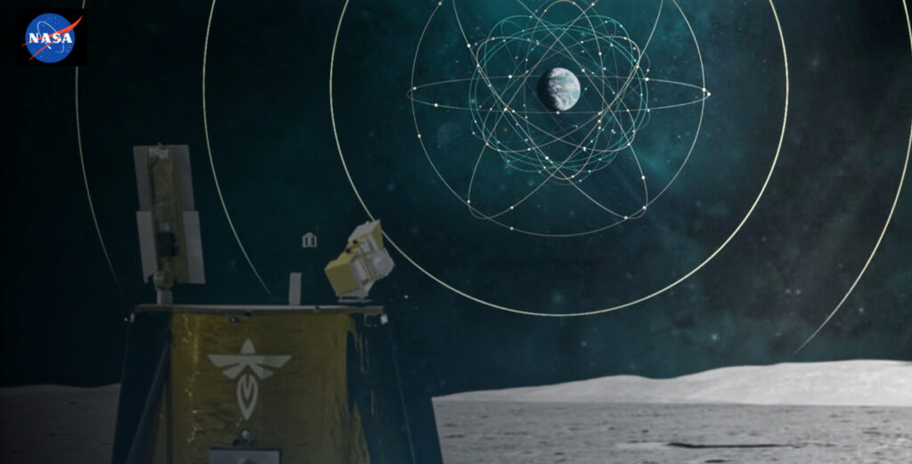
An artist’s concept of the Blue Ghost lunar lander receiving GNSS signals from Earth.
Credits: NASA/Dave Ryan

NASA and the Italian Space Agency made history on March 3rd when the Lunar GNSS Receiver Experiment (LuGRE) became the first technology demonstration to acquire and track Earth-based navigation signals on the Moon’s surface.  

Photo courtesy of NASA and ASI.

The LuGRE payload’s success in lunar orbit and on the surface indicates that signals from the GNSS (Global Navigation Satellite System) can be received and tracked at the Moon. These results mean NASA’s Artemis missions, or other exploration missions, could benefit from these signals to accurately and autonomously determine their position, velocity, and time. This represents a steppingstone to advanced navigation systems and services for the Moon and Mars.  

An artist's concept of the LuGRE payload on Blue Ghost and its three main records in transit to the Moon, in lunar orbit and on the Moon's surface.
An artist’s concept of the LuGRE payload on Blue Ghost and its three main records in transit to the Moon, in lunar orbit and on the Moon’s surface. Image: NASA/Dave Ryan

“On Earth we can use GNSS signals to navigate in everything from smartphones to airplanes,” said Kevin Coggins, deputy associate administrator for NASA’s SCaN (Space Communications and Navigation) Program.

“Now, LuGRE shows us that we can successfully acquire and track GNSS signals at the Moon. This is a very exciting discovery for lunar navigation, and we hope to leverage this capability for future missions.”  

The road to the historic milestone began on March 2 when the Firefly Aerospace’s Blue Ghost lunar lander touched down on the Moon and delivered LuGRE, one of 10 NASA payloads intended to advance lunar science. Soon after landing, LuGRE payload operators at NASA’s Goddard Space Flight Center in Greenbelt, Maryland, began conducting their first science operation on the lunar surface.

With the receiver data flowing in, anticipation mounted. Could a Moon-based mission acquire and track signals from two GNSS constellations, GPS and Galileo, and use those signals for navigation on the lunar surface?   

Then, at 2 a.m. EST on March 3, it was official: LuGRE acquired and tracked signals on the lunar surface for the first time ever and achieved a navigation fix — approximately 225,000 miles away from Earth.  

Firefly’s Blue Ghost lander captured its first sunrise on the Moon, marking the beginning of the lunar day and the start of surface operations in its new home. Image is courtesy of Firefly Aerospace.

Now that Blue Ghost is on the Moon, the mission will operate for 14 days providing NASA and the Italian Space Agency the opportunity to collect data in a near-continuous mode, leading to additional GNSS milestones. In addition to this record-setting achievement, LuGRE is the first Italian Space Agency developed hardware on the Moon, a milestone for the organization.  

The LuGRE payload also broke GNSS records on its journey to the Moon. On January 21, LuGRE surpassed the highest altitude GNSS signal acquisition ever recorded at 209,900 miles from Earth, a record formerly held by NASA’s Magnetospheric Multiscale Mission. Its altitude record continued to climb as LuGRE reached lunar orbit on Feb. 20 — 243,000 miles from Earth. This means that missions in cislunar space, the area of space between Earth and the Moon, could also rely on GNSS signals for navigation fixes.  

Traditionally, NASA engineers track spacecraft by using a combination of measurements, including onboard sensors and signals from Earth-based tracking stations. The LuGRE payload demonstrates that using GNSS signals for navigation can reduce reliance on human operators because these signals can be picked up and used autonomously by the spacecraft, even as far away as the Moon. 

The LuGRE payload is a collaborative effort between NASA’s Goddard Space Flight Center in Greenbelt, Maryland, the Italian Space Agency, their industry partner Qascom, and Politecnico di Torino. Funding and oversight for the LuGRE payload comes from NASA’s SCaN Program office. It was chosen by NASA as one of 10 funded research and technology demonstrations for delivery to the lunar surface by Firefly Aerospace Inc., a flight under the agency’s Commercial Lunar Payload Services initiative.

Article author: Katherine Schauer, NASA

Filed Under: Exploration & Science Missions, Government & Regulation

Primary Sidebar

Coverage

  • Missions & Constellations
  • Business & Finance
  • Military & Defense
  • Launch
  • Software Automation & Ground Systems
  • Government & Regulation
  • Services & Applications

Most Read Stories

  • SpaceX Acquires Grain Management’s 800 MHz Spectrum Portfolio to Launch Standalone Starlink Mobile Carrier
  • FCC Grants SpaceX Approval for 15,000-Satellite Very Low Earth Orbit Direct-to-Device Constellation
  • Rocket Lab Challenges NASA’s $700M Mars Orbiter Award to Blue Origin While Scaling Vertical Integration via $8B Iridium Acquisition
  • Amazon Leo Plans Prime Subscription Bundling to Challenge Starlink in Consumer Satellite Broadband Market
  • SpaceX Restricts Military Starshield Speeds in Ukraine, Disrupting Pentagon-Funded Tactical Drone Operations

Secondary Sidebar

Footer


Satnews is a leading provider of satellite news, events, publications, research and other satellite industry information in both commercial and military enterprises worldwide.

Stories By Category

  • Business & Finance
  • Government & Regulation
  • Launch
  • Military & Defense
  • Missions & Constellations
  • Services & Applications
  • Software Automation & Ground Systems
  • Spectrum & Licensing
  • Startups & NewSpace Business

About Us

  • Leadership & Editorial Team
  • SatNews History
  • Free Satnews Subscription
  • SatNews Events
  • Magazines

Navigation

  • Latest Stories
  • Magazines
  • Events
  • Contact
  • Cookie & Privacy Policy for Satnews

We use cookies to ensure that we give you the best experience on our website. If you continue to use this site we will assume that you are happy with it.
x
Sign up Now (For Free)
Access daily or weekly satellite news updates covering all aspects of the commercial and military satellite industry.
Invalid email address
Notify Me Regarding ( At least one ):
We value your privacy and will not sell or share your email or other information with any other company. You may also unsubscribe at anytime.

Click Here to see our full privacy policy.
Thanks for subscribing!