• Skip to primary navigation
  • Skip to main content
  • Skip to primary sidebar
  • Skip to secondary sidebar
  • Skip to footer
  • NEWS:
  • SatNews
  • SatMagazine
  • MilSatMagazine
  • SmallSat News
  • |     EVENTS:
  • SmallSat Symposium
  • Satellite Innovation
  • MilSat Symposium
  • SmallSat Europe

SatNews

Satellite Industry Intelligence Since 1983

Subscribe
  • LATEST
  • SatNews Events
  • Magazines
  • Calendar
  • Subscribe
  • Missions & Constellations
    • Exploration & Science Missions
    • In-Orbit Servicing & Orbital Operations
    • LEO Constellations
    • Mission Autonomy & Onboard Systems
    • Mission Deployments & Manifests
    • Navigation & PNT
    • SmallSat
    • Spacecraft & Payload Technology
    View All in Missions & Constellations →
    The Silent Overhaul: How Software-Defined Routing and Cloud Ingestion Flattened the Aerospace Hardware StackThe Silent Overhaul: How Software-Defined Routing and Cloud Ingestion Flattened the Aerospace Hardware Stack
    Hybrid Earth Intelligence: NASA Expands Commercial Satellite Data Integration in $476M Cloud-Driven PushHybrid Earth Intelligence: NASA Expands Commercial Satellite Data Integration in $476M Cloud-Driven Push
    Hybrid Edge Mobility: Contrivian Launches “Horizon Plus” to Deliver Intelligent Multi-Orbit Field CommunicationsHybrid Edge Mobility: Contrivian Launches “Horizon Plus” to Deliver Intelligent Multi-Orbit Field Communications
    Space Tech vs. Biothreat: GMV Deploys Earth Observation and AI Core to Fight Invasive Pacific Seaweed in PortugalSpace Tech vs. Biothreat: GMV Deploys Earth Observation and AI Core to Fight Invasive Pacific Seaweed in Portugal
  • Business
    • Contracts & Commercial Deals
    • Earnings & Financial Reporting
    • Events & Conferences
    • Funding & Venture Capital
    • Market Forecasts
    • Mergers & Acquisitions
    • Personnel Moves & Appointments
    View All in Business & Finance →
    The Spatial Photonics Crunch: Inside the Invisible Supply Chain Threatening Orbital Laser NetworksThe Spatial Photonics Crunch: Inside the Invisible Supply Chain Threatening Orbital Laser Networks
    Sovereign Space Expansion: Spain’s FOSSA Systems Secures €9.25M to Scale Defense Constellation and SIGINT InfrastructureSovereign Space Expansion: Spain’s FOSSA Systems Secures €9.25M to Scale Defense Constellation and SIGINT Infrastructure
    Next-Gen Spatial Intelligence: BAE Systems Secures Agreement to Build High-Resolution Vantage Satellite Buses for VantorNext-Gen Spatial Intelligence: BAE Systems Secures Agreement to Build High-Resolution Vantage Satellite Buses for Vantor
    New Lobbying Force: Top NGSO Operators Unveil “SpaceConnect Association” in WashingtonNew Lobbying Force: Top NGSO Operators Unveil “SpaceConnect Association” in Washington
  • Defense
    • Counterspace & ASAT
    • Defense Budgets & Procurement
    • ISR & Reconnaissance
    • MILSATCOM
    • Missile Warning & Defense
    • National Security Programs
    • Space Domain Awareness
    View All in Military & Defense →
    Digital Twins for Space Command: Sedaro Tapped by Space Force to Build Federated Engineering PlatformDigital Twins for Space Command: Sedaro Tapped by Space Force to Build Federated Engineering Platform
    The Strategic Redistribution of Iranian Aerospace CapabilityThe Strategic Redistribution of Iranian Aerospace Capability
    Navigating Contested Battlespaces: Military GPS Receiver Market Approaches $3 Billion Amid Electronic Warfare SurgeNavigating Contested Battlespaces: Military GPS Receiver Market Approaches $3 Billion Amid Electronic Warfare Surge
    Preparing for Day One: DARPA Solicits Tech to Rebuild Destroyed Satellite Fleets Within HoursPreparing for Day One: DARPA Solicits Tech to Rebuild Destroyed Satellite Fleets Within Hours
  • Gov
    • Export Controls & Compliance
    • International Space Agreements
    • National Space Policy
    • Space Law & Treaties
    • Space Sustainability & Debris Policy
    • Space Traffic Management / Debris Removal
    View All in Government & Regulation →
    $3.57 Billion Milestone: FCC Advanced Wireless Services (AWS-3) Spectrum Auction Concludes$3.57 Billion Milestone: FCC Advanced Wireless Services (AWS-3) Spectrum Auction Concludes
    Who Has Authority to Intervene in a Space-Based Emergency?Who Has Authority to Intervene in a Space-Based Emergency?
    Staying in Their Lanes: SpaceX and Globalstar Join Forces to Defend Spectrum ExclusivityStaying in Their Lanes: SpaceX and Globalstar Join Forces to Defend Spectrum Exclusivity
    Orbital Paperwork War: China’s Spectrum Squatting Reserves 244,000 Satellite Slots to Combat SpaceX’s LEO MonopolyOrbital Paperwork War: China’s Spectrum Squatting Reserves 244,000 Satellite Slots to Combat SpaceX’s LEO Monopoly
  • Launch
    • Launch Providers
    • Launch Schedule & Calendars
    • Launch Sites & Infrastructure
    • Rocket Technology & Vehicles
    View All in Launch →
    Arianespace fights back – possibly!Arianespace fights back – possibly!
    Direct-to-Device Momentum: AST SpaceMobile Successfully Launches Giant Next-Gen BlueBird Satellites Atop SpaceX Falcon 9Direct-to-Device Momentum: AST SpaceMobile Successfully Launches Giant Next-Gen BlueBird Satellites Atop SpaceX Falcon 9
    SpaceX’s Secret ‘Starfall’ Capsule Wins FAA Approval for Pacific Reentry TestsSpaceX’s Secret ‘Starfall’ Capsule Wins FAA Approval for Pacific Reentry Tests
    Breaking the TRL Bottleneck: Space Phoenix Systems Debuts Cost-Effective Space Test-and-Return ServiceBreaking the TRL Bottleneck: Space Phoenix Systems Debuts Cost-Effective Space Test-and-Return Service
  • Software
    • Autonomous Ground Operations
    • Data Processing & AI/ML
    • Digital Twins & Modeling
    • Ground Segment & Teleports
    • Mission Planning & Simulation
    • Space Systems Software Engineering
    • Spectrum & Licensing
    View All in Software Automation & Ground Systems →
    Powering the Automated Floor: Intralogistics Operators Must Unify AGV Charging InfrastructurePowering the Automated Floor: Intralogistics Operators Must Unify AGV Charging Infrastructure
    Poland Sovereignty: GMV to Develop Core Ground Control Platform for CAMILA ConstellationPoland Sovereignty: GMV to Develop Core Ground Control Platform for CAMILA Constellation
    Software Over the Air: FatPipe Launches Acceleration Tool to Unclog Starlink and Amazon LEO LinksSoftware Over the Air: FatPipe Launches Acceleration Tool to Unclog Starlink and Amazon LEO Links
    Three LEO Operators Bet 2026 on a Supply Chain Built for 2027Three LEO Operators Bet 2026 on a Supply Chain Built for 2027
  • Services & Apps
    • Climate & Environmental Monitoring
    • Disaster Response & Security Mapping
    • Earth Observation & Imaging
    • Maritime & Aviation Satcom
    • Satellite Communications
    View All in Services & Applications →
    National SAR Defense: Norway Selects ICEYE for Nationwide Space-Based Flood and Hazard Monitoring SystemNational SAR Defense: Norway Selects ICEYE for Nationwide Space-Based Flood and Hazard Monitoring System
    Sovereign Milestone: OQ Technology Achieves Europe’s First Drone Video Transmission via 3GPP NTN LEO SatelliteSovereign Milestone: OQ Technology Achieves Europe’s First Drone Video Transmission via 3GPP NTN LEO Satellite
    Ghost Viewers trigger secondary ripple effect on Satellite Communications (SatCom)Ghost Viewers trigger secondary ripple effect on Satellite Communications (SatCom)
    Fleet-Wide Hybrid Networks: Marlink Integrates Starlink Across 80+ Oldendorff Carriers VesselsFleet-Wide Hybrid Networks: Marlink Integrates Starlink Across 80+ Oldendorff Carriers Vessels

A SatNews Focus: Introducing Ursa Space’s Image Services

May 2, 2021

As the number of satellites launched into orbit continues to increase, the volume of imagery is growing exponentially, creating a trove of valuable insights waiting to be gleaned from the data. There are many SAR satellite providers responsible for this growth, creating lots of terrific options — how does one select the correct provider?

It would be easier If a significant amount of this imagery were housed under one roof, this selection task would be far easier… this is where Ursa Space enters the picture, with its recently launched Image Services offering. 

How can you realize this potential opportunity by accessing the satellite imagery, particularly from synthetic aperture radar (SAR) technology? 

Eric Cote

Eric Cote, a Product Manager at Ursa Space, recently highlighted the company’s new, image services offerings.

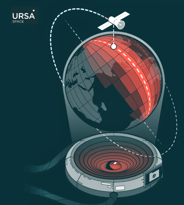
Ursa Space’s Image Services provides a one-stop source for commercial SAR imagery, he said. With this service, customers can search and order imagery from the company’s growing archive catalog of more than 8 million images and 14 years of history. Customers can also use this service to task new images from the firm’s Virtual Constellation, the world’s largest network of SAR satellites from vendor partners. Ursa Space has partnered with a number of SAR providers, so when someone comes to us, they instantly have access to all of the imagery in each provider’s archives as well as access to task new images from each provider’s satellite network.

This image shows some of the existing imagery available from Ursa Space’s Virtual Constellation catalog.
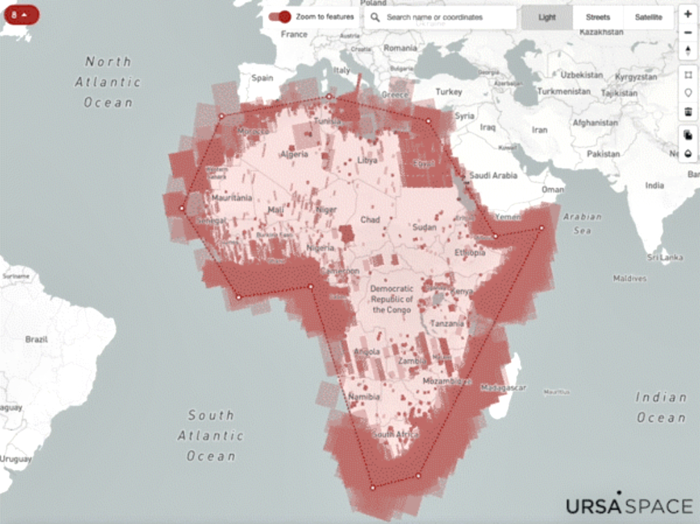
For this example, parameters included some of the major SAR providers covering Africa during a selected time period. 

When someone wants an image for an upcoming date, they tell us the basics—where and when—and Ursa Space handles the rest. More advanced users can also choose to provide detailed collection criteria and we’ll do all the legwork to obtain the images that meet the customer’s requirements from our satellite provider partners.

A sample of SAR imagery from some of Ursa Space’s Virtual Constellation satellite partners

An additional step between order and delivery is processing. Without going into too much technical detail, let’s just say that there are different formats for SAR imagery. If someone is trying to understand and interpret imagery across multiple vendors or formats, they will run into problems without the proper training. People can work with us instead. We have the in-house SAR processing expertise to turn multiple data formats into one common vendor-independent format, which is then delivered to the customer, ready to be used. 

Without the proper corrections, a structure or feature might not appear in the same location within each image, leading an individual to conclude that the feature has either changed significantly or disappeared, when in fact, it’s just a technical error because the different formats weren’t properly accounted for in the final product. 

Imagery from Airbus (2019). Processed by Ursa Space Systems (2021). This is a SAR image of Paris by Airbus which was then processed into a “Point of View” perspective by Ursa Space.

Timing is often a crucial factor when a client needs an image. Ursa Space will take care of the processing and deliver the image in one common format. There’s also the benefit of Ursa Space working with multiple SAR providers on your behalf, so you won’t get caught without a backup plan in case of unexpected maintenance or availability issues with a single vendor. We can provide a reliable delivery schedule by tasking a satellite from another provider that’s a part of our Virtual Constellation.

There are any number of motivations behind imagery acquisition. For example, if there’s a natural disaster, say a hurricane in Florida, then an insurance company might want imagery to understand the impact of the storm on infrastructure. Where is there flooding? Or, where did buildings sustain the most damage from high winds? 

The extent of damage can be quickly understood by pulling an archived image to establish a baseline against which the post-event image is compared. This example also makes clear why the benefits of SAR can be critical at times. Unlike optical imagery, SAR works in any weather, day or night. That’s a critical distinction when trying to assess the situation on the ground right after a major storm hits and clouds obstruct the view.  

Ursa Space can also assist with image analytics. Using the same example, the company can identify and quantify the damage inflicted by the storm, such as flood mapping or highlighting infrastructure changes.

The image above shows the processing and analytics done by Ursa Space on a SAR image provided by ICEYE,
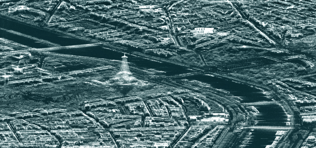
collected off the coast of Mauritius in August of 2020, after a ship ran aground, leaking oil into the ocean.
The area highlighted in red is the oil slick.

Another use case is economic monitoring. We can perform analytics to measure economic activity, which is why the archive is so important. Having extensive historical data is critical when trying to interpret current information. That’s true whether it’s a financial firm fine-tuning a trading algorithm, or a local municipality assessing property valuations.

Ursa Space has a streamlined process for searching our catalog, ordering, processing, analyzing, and delivering SAR imagery across a Virtual Constellation from our satellite partners. This provides enhanced capabilities and redundancy when compared to any one vendor alone. Customers can therefore take advantage of the ongoing satellite revolution. As fast as turnaround times are today, they will only improve moving forward.

To learn more about Ursa Space’s Image Services, please access this direct link…

Filed Under: Earth Observation & Imaging, Market Forecasts

Primary Sidebar

Coverage

  • Missions & Constellations
  • Business & Finance
  • Military & Defense
  • Launch
  • Software Automation & Ground Systems
  • Government & Regulation
  • Services & Applications

Most Read Stories

  • SpaceX’s Secret ‘Starfall’ Capsule Wins FAA Approval for Pacific Reentry Tests
  • American military space closed around one company in seven days
  • Analyst Projects Massive Subscription Growth for Starlink Ahead of Imminent SpaceX IPO
  • Major opportunities for 2 GHz over Europe
  • Amazon Leo Constellation Surpasses 330 Satellites Following Latest Atlas V Launch

Secondary Sidebar

Footer


Satnews is a leading provider of satellite news, events, publications, research and other satellite industry information in both commercial and military enterprises worldwide.

Stories By Category

  • Business & Finance
  • Government & Regulation
  • Launch
  • Military & Defense
  • Missions & Constellations
  • Services & Applications
  • Software Automation & Ground Systems
  • Spectrum & Licensing
  • Startups & NewSpace Business

About Us

  • Leadership & Editorial Team
  • SatNews History
  • Free Satnews Subscription
  • SatNews Events
  • Magazines

Navigation

  • Latest Stories
  • Magazines
  • Events
  • Contact
  • Cookie & Privacy Policy for Satnews

We use cookies to ensure that we give you the best experience on our website. If you continue to use this site we will assume that you are happy with it.
x
Sign up Now (For Free)
Access daily or weekly satellite news updates covering all aspects of the commercial and military satellite industry.
Invalid email address
Notify Me Regarding ( At least one ):
We value your privacy and will not sell or share your email or other information with any other company. You may also unsubscribe at anytime.

Click Here to see our full privacy policy.
Thanks for subscribing!