

• Skip to primary navigation
  • Skip to main content
  • Skip to primary sidebar
  • Skip to secondary sidebar
  • Skip to footer
  • NEWS:
  • SatNews
  • SatMagazine
  • MilSatMagazine
  • SmallSat News
  • |     EVENTS:
  • SmallSat Symposium
  • Satellite Innovation
  • MilSat Symposium
  • SmallSat Europe

SatNews

Satellite Industry Intelligence Since 1983

Subscribe
  • LATEST
  • SatNews Events
  • Magazines
  • Calendar
  • Subscribe
  • Missions & Constellations
    • Exploration & Science Missions
    • In-Orbit Servicing & Orbital Operations
    • LEO Constellations
    • Mission Autonomy & Onboard Systems
    • Mission Deployments & Manifests
    • Navigation & PNT
    • SmallSat
    • Spacecraft & Payload Technology
    View All in Missions & Constellations →
    Apple’s Space Strategy: Capital Orchestration Over Orbital Hardware OperationsApple’s Space Strategy: Capital Orchestration Over Orbital Hardware Operations
    All Points Awarded On-Ramp to NASA Spacecraft Processing and Operations ContractAll Points Awarded On-Ramp to NASA Spacecraft Processing and Operations Contract
    Enterprise Sector Adopts Vertical Analytics Platforms and APIs to Replace Raw Satellite ImageryEnterprise Sector Adopts Vertical Analytics Platforms and APIs to Replace Raw Satellite Imagery
    Commercial Demand Drives Earth Observation Small Satellite Market Toward $6.90 Billion by 2034Commercial Demand Drives Earth Observation Small Satellite Market Toward $6.90 Billion by 2034
  • Business
    • Contracts & Commercial Deals
    • Earnings & Financial Reporting
    • Events & Conferences
    • Funding & Venture Capital
    • Market Forecasts
    • Mergers & Acquisitions
    • Personnel Moves & Appointments
    View All in Business & Finance →
    Integrasys Awarded €2.89 Million in Luxembourg Defense R&D ProjectsIntegrasys Awarded €2.89 Million in Luxembourg Defense R&D Projects
    Silicon Valley Space Week Speaker Focus: Janna Lewis, Astroscale U.S.Silicon Valley Space Week Speaker Focus: Janna Lewis, Astroscale U.S.
    Lynk Global and Omnispace Complete Merger to Form Direct-to-Device Operator Elveo MobileLynk Global and Omnispace Complete Merger to Form Direct-to-Device Operator Elveo Mobile
    Resolve Optics Delivers Radiation-Resistant Star Tracker Lenses for Satellite Attitude ControlResolve Optics Delivers Radiation-Resistant Star Tracker Lenses for Satellite Attitude Control
  • Defense
    • Counterspace & ASAT
    • Defense Budgets & Procurement
    • ISR & Reconnaissance
    • MILSATCOM
    • Missile Warning & Defense
    • National Security Programs
    • Space Domain Awareness
    View All in Military & Defense →
    Viasat Selects Rocket Lab to Build Small GEO Satellite Bus for Space Force PTS-G ProgramViasat Selects Rocket Lab to Build Small GEO Satellite Bus for Space Force PTS-G Program
    Ukrainian Missile Strike Damages Russian Space Facility Producing Rassvet Broadband RocketsUkrainian Missile Strike Damages Russian Space Facility Producing Rassvet Broadband Rockets
    U.S. Space Force and Japan Complete QZSS Hosted-Payload Program with Launch of QZS-7U.S. Space Force and Japan Complete QZSS Hosted-Payload Program with Launch of QZS-7
    Impulse Space Secures $28 Million Space Force Contract Extension for VICTUS SALO MissionsImpulse Space Secures $28 Million Space Force Contract Extension for VICTUS SALO Missions
  • Gov
    • Export Controls & Compliance
    • International Space Agreements
    • National Space Policy
    • Space Law & Treaties
    • Space Sustainability & Debris Policy
    • Space Traffic Management / Debris Removal
    View All in Government & Regulation →
    DarkSky International Petitions Full FCC to Overturn Approval of Reflect Orbital’s Space-Mirror SatelliteDarkSky International Petitions Full FCC to Overturn Approval of Reflect Orbital’s Space-Mirror Satellite
    FCC Opens Proceeding to Unlock 200 MHz of Unlicensed Spectrum for Direct-to-Device Satellite LinksFCC Opens Proceeding to Unlock 200 MHz of Unlicensed Spectrum for Direct-to-Device Satellite Links
    SpaceX Regulatory Strategy at the FCC: Disruptive Expansion Meets Administrative OversightSpaceX Regulatory Strategy at the FCC: Disruptive Expansion Meets Administrative Oversight
    Greece Unveils €350 Million Hellas-Space 2.0 National Space ProgrammeGreece Unveils €350 Million Hellas-Space 2.0 National Space Programme
  • Launch
    • Launch Providers
    • Launch Schedule & Calendars
    • Launch Sites & Infrastructure
    • Rocket Technology & Vehicles
    View All in Launch →
    SpaceX Establishes 38-Minute Dual-Coast Launch Record as Industry Evaluates High-Cadence BenchmarksSpaceX Establishes 38-Minute Dual-Coast Launch Record as Industry Evaluates High-Cadence Benchmarks
    Arianespace Pauses ICARUS Carbon-Composite Upper Stage Upgrade to Focus on Ariane 6 Production RampArianespace Pauses ICARUS Carbon-Composite Upper Stage Upgrade to Focus on Ariane 6 Production Ramp
    Long March 7A Rocket Explodes During ChinaSat 4B Launch from WenchangLong March 7A Rocket Explodes During ChinaSat 4B Launch from Wenchang
    Projected Starship Cost Collapse Redefines Low Earth Orbit Infrastructure EconomicsProjected Starship Cost Collapse Redefines Low Earth Orbit Infrastructure Economics
  • Software
    • Autonomous Ground Operations
    • Data Processing & AI/ML
    • Digital Twins & Modeling
    • Ground Segment & Teleports
    • Mission Planning & Simulation
    • Space Systems Software Engineering
    • Spectrum & Licensing
    View All in Software Automation & Ground Systems →
    Astrolight Advances End-to-End Lasercom Network to Address Orbital Bandwidth and Spectrum BottlenecksAstrolight Advances End-to-End Lasercom Network to Address Orbital Bandwidth and Spectrum Bottlenecks
    Intellian Unveils CM100 GMDSS Terminal Built for Iridium Certus 100 Safety NetworkIntellian Unveils CM100 GMDSS Terminal Built for Iridium Certus 100 Safety Network
    NASA Joins Federal Genesis Mission Initiative to Process 150 Petabytes of Space Data via AI ArchitecturesNASA Joins Federal Genesis Mission Initiative to Process 150 Petabytes of Space Data via AI Architectures
    IHI Corporation and Kuva Space Partner to Evaluate Japanese Sovereign Hyperspectral ConstellationIHI Corporation and Kuva Space Partner to Evaluate Japanese Sovereign Hyperspectral Constellation
  • Services & Apps
    • Climate & Environmental Monitoring
    • Disaster Response & Security Mapping
    • Earth Observation & Imaging
    • Maritime & Aviation Satcom
    • Satellite Communications
    View All in Services & Applications →
    Planet Labs Secures Seven-Figure Agricultural Data Contract with Scottish GovernmentPlanet Labs Secures Seven-Figure Agricultural Data Contract with Scottish Government
    Nilesat Secures Tier 4 WTA Certification for Cairo Teleport InfrastructureNilesat Secures Tier 4 WTA Certification for Cairo Teleport Infrastructure
    Resecurity Joins Space ISAC to Expand Cyber Threat Intelligence Across Space AssetsResecurity Joins Space ISAC to Expand Cyber Threat Intelligence Across Space Assets
    Telespazio Deploys S/X-Band Antenna in the Azores to Expand Global Ground Station NetworkTelespazio Deploys S/X-Band Antenna in the Azores to Expand Global Ground Station Network

Naval Research Laboratory (NRL)… A First Ever… (Remote Sensing)

May 21, 2012

[SatNews] Naval Research Laboratory scientists have obtained a first-ever measured altitude profile of a…

…dim extreme-ultraviolet terrestrial airglow emission that provides vital information needed to test and improve the accuracy of advanced techniques for remote sensing of the daytime ionosphere. They have obtained this altitude profile using scans from the Remote Atmospheric and Ionospheric Detection System (RAIDS) experiment. The results of the research are published in the Journal of Geophysical Research, 117, A01316, (2012).
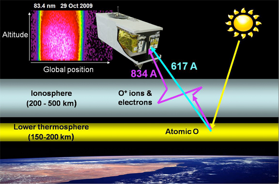

This image shows a schematic representation of the dayside ionosphere remote sensing concept, using measurement of the scattered 83.4 nm emission to infer ionospheric densities. Measuring the 61.7 nm emission provides direct information on the intensity of the source region in the lower thermosphere that is currently only modeled for operational algorithms.
(Image: U.S. Naval Research Laboratory)

RAIDS temperature measurements have already directly contributed to the Calibration/Validation of the operational (NRL-led) Special Sensor Ultraviolet Limb Imager (SSULI) sensors aboard the DoD Defense Meteorological Satellite Program satellites. This new result from RAIDS will lead to improved operational algorithms for characterizing the vertical structure and global morphology of the ionosphere, the weakly ionized plasma surrounding Earth that affects Navy applications such as high-frequency communication and over-the-horizon radar.

The RAIDS experiment, jointly built by NRL and The Aerospace Corporation, is a suite of eight optical sensors spanning ultraviolet to infrared wavelengths. Under the direction of the DoD Space Test Program, RAIDS and the companion NRL Hyperspectral Imager for Coastal Oceans (HICO) experiment were integrated and flown as the HICO-RAIDS Experiment Payload (HREP) on the International Space Station Japanese Experiment Module-Exposed Facility (JEM-EF). RAIDS exceeded its mission goals by collecting more than 1 million scans of the terrestrial airglow between September 2009 and December 2010, and has continued to collect downward-looking spectra since early 2011. RAIDS is the latest in a significant line of NRL Space Science Division (SSD) sensors designed to advance methods and algorithms for remote sensing of the near-Earth space environment.

One high-priority science focus of RAIDS was the development of new ionospheric remote sensing techniques that use extreme-ultraviolet airglow features of O+ at 61.7 and 83.4 nm wavelengths. These naturally-occurring airglow emissions are particularly useful for this purpose in that strong absorption of these wavelengths in the lower atmosphere means that all the observed light comes from the upper atmosphere. The emissions are created initially when the Sun ionizes atomic oxygen in the region of 150-200 km, but the resulting 83.4 nm photons are scattered by O+ in the ionospheric region between 200-500 km. Ionospheric densities are inferred by modeling how this scattering process changes the measured 83.4 nm intensity. In effect, the ionosphere is like a thin fog whose characteristics are revealed via illumination by the 83.4 nm airglow from below. The 61.7 nm feature, which is not affected by scattering, provides the missing link to directly connect the intensity of the illuminating source in the lower atmosphere to the measured 83.4 nm profile, allowing the O+ density to be pinpointed.
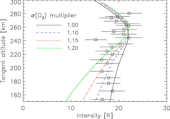

This graph, a 61.7 nm profile measured by RAIDS, is compared to the current model. Allowing for variations in absorption (σ) by O2 indicates that neutral composition used in the model may be in error by ~15%. Thus, the accuracy of algorithms used to infer ionospheric density can be improved by using the 61.7 nm emission directly.
(Image: U.S. Naval Research Laboratory)

NRL Space Science Division (SSD) researchers Dr. Andrew Stephan and Dr. Scott Budzien, along with retired SSD researcher Dr. J. Michael Picone (now at George Mason University) and colleagues at The Aerospace Corporation, analyzed RAIDS data for 29 Oct 2009 to provide the first independent test of the model that is currently used as part of this daytime ionospheric remote sensing method. The data show good agreement with the model, although subtle differences suggest changes on the order of 15 percent to the densities of specific neutral species are needed on this day to bring the two into agreement. These small differences confirm the notion that uncertainty in the density of the neutral atmosphere remains an important limitation to high-accuracy ionospheric specification. Results from this study will be used to refine this ionospheric remote sensing technique and remove these limitations to meet the growing need for understanding this important region of space.

Filed Under: ISR & Reconnaissance

Primary Sidebar

Coverage

  • Missions & Constellations
  • Business & Finance
  • Military & Defense
  • Launch
  • Software Automation & Ground Systems
  • Government & Regulation
  • Services & Applications

Most Read Stories

  • SpaceX Targets First Starship Upper Stage Tower Catch for Flight 14
  • SpaceX Limits Future Commercial Rideshare Bookings Past 2028 Amid Severe Manifest Saturation
  • EchoStar Faces Mounting Financial Pressure on Hughes Satellite Unit Amid Corporate Reorganization
  • NASA and ISISPACE Deploy GRITSS CubeSat to Advance Orbital Reference Frame Precision
  • FCC Proposes Opening Unlicensed Bluetooth and Wi-Fi Bands for Space-Based Communications

Secondary Sidebar

Footer


Satnews is a leading provider of satellite news, events, publications, research and other satellite industry information in both commercial and military enterprises worldwide.

Stories By Category

  • Business & Finance
  • Government & Regulation
  • Launch
  • Military & Defense
  • Missions & Constellations
  • Services & Applications
  • Software Automation & Ground Systems
  • Spectrum & Licensing
  • Startups & NewSpace Business

About Us

  • Leadership & Editorial Team
  • SatNews History
  • Free Satnews Subscription
  • SatNews Events
  • Magazines

Navigation

  • Latest Stories
  • Magazines
  • Events
  • Contact
  • Cookie & Privacy Policy for Satnews

We use cookies to ensure that we give you the best experience on our website. If you continue to use this site we will assume that you are happy with it.
x
Sign up Now (For Free)
Access daily or weekly satellite news updates covering all aspects of the commercial and military satellite industry.
Invalid email address
Notify Me Regarding ( At least one ):
We value your privacy and will not sell or share your email or other information with any other company. You may also unsubscribe at anytime.

Click Here to see our full privacy policy.
Thanks for subscribing!