

• Skip to primary navigation
  • Skip to main content
  • Skip to primary sidebar
  • Skip to secondary sidebar
  • Skip to footer
  • NEWS:
  • SatNews
  • SatMagazine
  • MilSatMagazine
  • SmallSat News
  • |     EVENTS:
  • SmallSat Symposium
  • Satellite Innovation
  • MilSat Symposium
  • SmallSat Europe

SatNews

Satellite Industry Intelligence Since 1983

Subscribe
  • LATEST
  • SatNews Events
  • Magazines
  • Calendar
  • Subscribe
  • Missions & Constellations
    • Exploration & Science Missions
    • In-Orbit Servicing & Orbital Operations
    • LEO Constellations
    • Mission Autonomy & Onboard Systems
    • Mission Deployments & Manifests
    • Navigation & PNT
    • SmallSat
    • Spacecraft & Payload Technology
    View All in Missions & Constellations →
    Silicon Sensing Launches Zenith Closed-Loop MEMS Accelerometer for Spacecraft StabilizationSilicon Sensing Launches Zenith Closed-Loop MEMS Accelerometer for Spacecraft Stabilization
    Shield AI and Sedaro Validate On-Orbit AI Pilot and Edge Autonomy Onboard LEO SatelliteShield AI and Sedaro Validate On-Orbit AI Pilot and Edge Autonomy Onboard LEO Satellite
    Kongsberg NanoAvionics Unveils 500 kg MP42D Platform and Defense-Focused Gen-2 Satellite LineupKongsberg NanoAvionics Unveils 500 kg MP42D Platform and Defense-Focused Gen-2 Satellite Lineup
    ICEYE Establishes Indian Subsidiary to Supply Sovereign SAR Intelligence and Domestic ManufacturingICEYE Establishes Indian Subsidiary to Supply Sovereign SAR Intelligence and Domestic Manufacturing
  • Business
    • Contracts & Commercial Deals
    • Earnings & Financial Reporting
    • Events & Conferences
    • Funding & Venture Capital
    • Market Forecasts
    • Mergers & Acquisitions
    • Personnel Moves & Appointments
    View All in Business & Finance →
    T-Mobile CFO Cites Physical Laws Limiting Satellite Direct-to-Device Networks to Complementary CoverageT-Mobile CFO Cites Physical Laws Limiting Satellite Direct-to-Device Networks to Complementary Coverage
    Silicon Valley Space Week Speaker Focus: Dr. David Denhard, U.S. Space CommandSilicon Valley Space Week Speaker Focus: Dr. David Denhard, U.S. Space Command
    Sovereign Satellite Strategy Expands AST SpaceMobile Backlog Amid Constellation Deployment RisksSovereign Satellite Strategy Expands AST SpaceMobile Backlog Amid Constellation Deployment Risks
    Shanghai Spacecom Raises 7 Billion Yuan Series B Round at $6.96 Billion ValuationShanghai Spacecom Raises 7 Billion Yuan Series B Round at $6.96 Billion Valuation
  • Defense
    • Counterspace & ASAT
    • Defense Budgets & Procurement
    • ISR & Reconnaissance
    • MILSATCOM
    • Missile Warning & Defense
    • National Security Programs
    • Space Domain Awareness
    View All in Military & Defense →
    Ground Infrastructure Vulnerabilities Accelerate Industry Transition to Cloud-Based SATCOM VirtualizationGround Infrastructure Vulnerabilities Accelerate Industry Transition to Cloud-Based SATCOM Virtualization
    ThinKom Awarded $49 Million U.S. Army OTA Contract for Mobile C-UAS High-Power Microwave PrototypeThinKom Awarded $49 Million U.S. Army OTA Contract for Mobile C-UAS High-Power Microwave Prototype
    Viasat Selects Rocket Lab to Build Small GEO Satellite Bus for Space Force PTS-G ProgramViasat Selects Rocket Lab to Build Small GEO Satellite Bus for Space Force PTS-G Program
    Integrasys Awarded €2.89 Million in Luxembourg Defense R&D ProjectsIntegrasys Awarded €2.89 Million in Luxembourg Defense R&D Projects
  • Gov
    • Export Controls & Compliance
    • International Space Agreements
    • National Space Policy
    • Space Law & Treaties
    • Space Sustainability & Debris Policy
    • Space Traffic Management / Debris Removal
    View All in Government & Regulation →
    Satellite Industry Association Endorses White House Space Transportation Policy DirectiveSatellite Industry Association Endorses White House Space Transportation Policy Directive
    DarkSky International Petitions Full FCC to Overturn Approval of Reflect Orbital’s Space-Mirror SatelliteDarkSky International Petitions Full FCC to Overturn Approval of Reflect Orbital’s Space-Mirror Satellite
    FCC Opens Proceeding to Unlock 200 MHz of Unlicensed Spectrum for Direct-to-Device Satellite LinksFCC Opens Proceeding to Unlock 200 MHz of Unlicensed Spectrum for Direct-to-Device Satellite Links
    SpaceX Regulatory Strategy at the FCC: Disruptive Expansion Meets Administrative OversightSpaceX Regulatory Strategy at the FCC: Disruptive Expansion Meets Administrative Oversight
  • Launch
    • Launch Providers
    • Launch Schedule & Calendars
    • Launch Sites & Infrastructure
    • Rocket Technology & Vehicles
    View All in Launch →
    NASA Roman Space Telescope Passes Flight Readiness Review Ahead of SpaceX Falcon Heavy LaunchNASA Roman Space Telescope Passes Flight Readiness Review Ahead of SpaceX Falcon Heavy Launch
    ISRO Transitions Rocket Manufacturing to Domestic Private Sector to Scale India’s Space EconomyISRO Transitions Rocket Manufacturing to Domestic Private Sector to Scale India’s Space Economy
    United Launch Alliance Upsizes Private Bond Offering to $1.5 Billion to Fund Infrastructure ExpansionUnited Launch Alliance Upsizes Private Bond Offering to $1.5 Billion to Fund Infrastructure Expansion
    INNOSPACE Terminates Initial Flight Test of SEBIT Suborbital Rocket Following Trajectory AnomalyINNOSPACE Terminates Initial Flight Test of SEBIT Suborbital Rocket Following Trajectory Anomaly
  • Software
    • Autonomous Ground Operations
    • Data Processing & AI/ML
    • Digital Twins & Modeling
    • Ground Segment & Teleports
    • Mission Planning & Simulation
    • Space Systems Software Engineering
    • Spectrum & Licensing
    View All in Software Automation & Ground Systems →
    Astrolight Advances End-to-End Lasercom Network to Address Orbital Bandwidth and Spectrum BottlenecksAstrolight Advances End-to-End Lasercom Network to Address Orbital Bandwidth and Spectrum Bottlenecks
    Intellian Unveils CM100 GMDSS Terminal Built for Iridium Certus 100 Safety NetworkIntellian Unveils CM100 GMDSS Terminal Built for Iridium Certus 100 Safety Network
    NASA Joins Federal Genesis Mission Initiative to Process 150 Petabytes of Space Data via AI ArchitecturesNASA Joins Federal Genesis Mission Initiative to Process 150 Petabytes of Space Data via AI Architectures
    IHI Corporation and Kuva Space Partner to Evaluate Japanese Sovereign Hyperspectral ConstellationIHI Corporation and Kuva Space Partner to Evaluate Japanese Sovereign Hyperspectral Constellation
  • Services & Apps
    • Climate & Environmental Monitoring
    • Disaster Response & Security Mapping
    • Earth Observation & Imaging
    • Maritime & Aviation Satcom
    • Satellite Communications
    View All in Services & Applications →
    Astrolight Advances Open-Standard Lasercom Architecture for Multi-Vendor Space NetworksAstrolight Advances Open-Standard Lasercom Architecture for Multi-Vendor Space Networks
    Lynk Global and Omnispace Complete Merger to Form Direct-to-Device Operator Elveo MobileLynk Global and Omnispace Complete Merger to Form Direct-to-Device Operator Elveo Mobile
    Planet Labs Secures Seven-Figure Agricultural Data Contract with Scottish GovernmentPlanet Labs Secures Seven-Figure Agricultural Data Contract with Scottish Government
    Nilesat Secures Tier 4 WTA Certification for Cairo Teleport InfrastructureNilesat Secures Tier 4 WTA Certification for Cairo Teleport Infrastructure

Here’s Looking @ Earth… Weather Nasties—Hilary + Nesat (Imagery)

September 26, 2011

[SatNews] One hurricane and one typhoon are aiming for landfall…


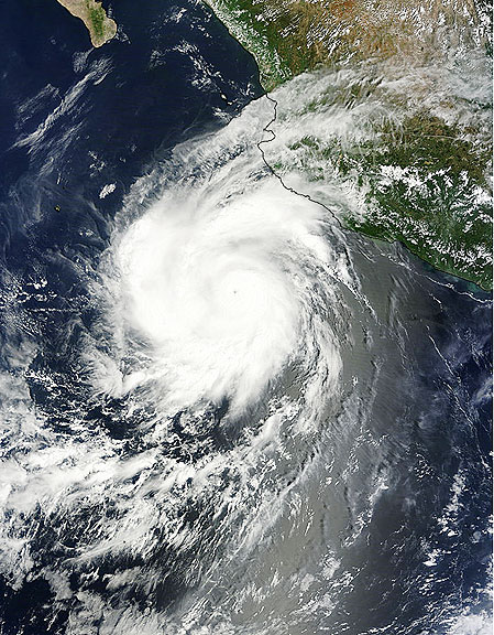
This visible image of Hurricane Hilary was captured by the MODIS instrument on Saturday, Sept. 24 at 17:40 UTC (1:40 p.m. EDT) when it was off the west coast of Mexico. Credit: NASA Goddard MODIS Rapid Response Team
Text credit: Rob Gutro, NASA’s Goddard Space Flight Center, Greenbelt, Md.
Hurricane Hilary pulled away from the western Mexico coastline this weekend, and NASA‘s TRMM satellite has monitored its rainfall. Hilary’s heaviest rainfall is in its northwest quadrant, and falling over open ocean today, but Hilary may be headed back toward land. NASA’s Tropical Rainfall Measuring Mission satellite known as TRMM passed over Hilary on Sept. 26 at 5:29 a.m. EDT and its precipitation radar instrument measured rainfall happening throughout the storm from its orbit in space. TRMM saw that most of the rainfall occurring in Hurricane Hilary today was moderate, and the heaviest area was limited to its northwestern quadrant where rain was coming down at 2 inches/50 mm per hour. TRMM also has the ability to measure cloud heights, which indicate the power within a hurricane. The higher the towering clouds around the eye, usually the stronger the power within the hurricane. TRMM noticed that the highest cumulonimbus (thunderstorm) clouds in the center were around 14 kilometers (8.6 miles). Towering clouds that height are indicative of a lot of power in the storm.

At 5:00 a.m. EDT (2:00 a.m. PDT) on Sept. 26, Hilary’s maximum sustained winds were near 120 mph (195 kmh). It was centered near 16.9 North and 112.2 West, about 440 miles (710 km) south-southwest of the southern tip of Baja California. It is moving away from Mexico to the west at 10 mph (17 kmh) and has a minimum central pressure of 959 millibars. Hilary is going through some changes today. It appears slightly elongated today from north to south. Cloud top temperatures in infrared satellite imagery indicate that her cloud tops are cooling, indicating they’re going higher (and getting stronger). The National Hurricane Center forecast calls for Hilary to change course and take a northeastern track, coming close to Baja California by the end of the week, but as a depression. Forecasters and NASA satellites are keeping a close eye on Hilary this week.


This visible image of Typhoon Nesat was captured by the MODIS instrument on Sunday, Sept. 25 at 2:40 UTC as its western edges began to spread over the Philippines. Nesat’s eye is not visible in this image. Credit: NASA Goddard MODIS Rapid Response Team
Text credit: Rob Gutro NASA/Goddard Space Flight Center, Greenbelt, Md.
NASA’s Terra satellitea saw the western edges of Typhoon Nesat brushing the eastern Philippines yesterday as Luzon prepares for a landfall today. Warning Signals are in effect throughout the northern Philippines as the typhoon nears. NASA’s Terra satellite flew over Typhoon Nesat yesterday. Nesat is known locally in the Philippines as “Pedring.” NASA’s Moderate Resolution Imaging Spectroradiometer (MODIS) captured a visible image of the large storm on Sunday, Sept. 25 at 2:40 UTC (10:40 a.m. local time/Philippines) as its western edges began to spread over the Philippines. Although the visible image did not reveal an eye because it was cloud-filled, satellite microwave imagery did spot the eye. Typhoon Nesat has maximum sustained winds near 80 knots (92 mph/148 kmh) on Monday, Sept. 26 as its center approaches northern Luzon, Philippines. It was located only 225 miles east-northwest of Manila, near 15.9 North and 124.2 East. It was moving to the west-northwest near 14 knots (16 mph/26 kmh).

Satellite imagery shows tightly-curved bands of thunderstorms wrapping into the low level center of circulation. That’s an indication the storm is well-organized. The strongest convection and thunderstorms are mostly over the western semi-circle of the storm today. Microwave satellite data does reveal Nesat has an eye which helps forecasters pinpoint Nesat’s center. PAGASA, the Philippines’ meteorological service expects Nesat (Pedring) will make landfall Tuesday afternoon (local time/Philippines) over Casiguran, Aurora and will be in the vicinity of Baguio City. Coastal areas can expect dangerous surf and high ocean swells, heavy rainfall and gusty winds. Many watches and warnings are in effect. A Signal 3 (for the strongest winds) has been posted for many locales. The Joint Typhoon Warning Center forecasts Nesat to continue tracking due west over Luzon and make landfall with maximum sustained winds near 90 knots (103 mph/166 kmh). It is forecast to cross Luzon and move into the South China Sea in one day.

Filed Under: Disaster Response & Security Mapping, Earth Observation & Imaging

Primary Sidebar

Coverage

  • Missions & Constellations
  • Business & Finance
  • Military & Defense
  • Launch
  • Software Automation & Ground Systems
  • Government & Regulation
  • Services & Applications

Most Read Stories

  • EchoStar Faces Mounting Financial Pressure on Hughes Satellite Unit Amid Corporate Reorganization
  • NASA and ISISPACE Deploy GRITSS CubeSat to Advance Orbital Reference Frame Precision
  • FCC Proposes Opening Unlicensed Bluetooth and Wi-Fi Bands for Space-Based Communications
  • FCC Approves Upper C-Band Order, Allocating $5.6 Billion to SES and $504 Million to Eutelsat
  • Viasat Advances Equatys D2D Joint Venture Toward Initial Constellation Procurement

Secondary Sidebar

Footer


Satnews is a leading provider of satellite news, events, publications, research and other satellite industry information in both commercial and military enterprises worldwide.

Stories By Category

  • Business & Finance
  • Government & Regulation
  • Launch
  • Military & Defense
  • Missions & Constellations
  • Services & Applications
  • Software Automation & Ground Systems
  • Spectrum & Licensing
  • Startups & NewSpace Business

About Us

  • Leadership & Editorial Team
  • SatNews History
  • Free Satnews Subscription
  • SatNews Events
  • Magazines

Navigation

  • Latest Stories
  • Magazines
  • Events
  • Contact
  • Cookie & Privacy Policy for Satnews

We use cookies to ensure that we give you the best experience on our website. If you continue to use this site we will assume that you are happy with it.
x
Sign up Now (For Free)
Access daily or weekly satellite news updates covering all aspects of the commercial and military satellite industry.
Invalid email address
Notify Me Regarding ( At least one ):
We value your privacy and will not sell or share your email or other information with any other company. You may also unsubscribe at anytime.

Click Here to see our full privacy policy.
Thanks for subscribing!