
NASA Earth Observatory image by Robert Simmon. Caption by Rebecca Lindsey.
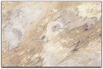
This natural-color image shows the most dramatic group of mud volcanoes in the area, known as the Changradup Complex. The tallest volcano, Changradup I, is about 100 meters (330 feet) high, and it has a 15-meter- (49-foot-) diameter mud lake in its crater that periodically overflows. Some of these overflows have darkened the northwestern flanks. A second crater emerges from the southern flanks of Changradup, but it is not currently active.
The 45-meter (150-foot) Chandragup II lies northeast of the taller cone, and its crater is filled by a mud lake with a figure-8 shape, probably the result of twin volcanoes whose craters collapsed into each other over time. To the northwest of Changradup I, the eroded rim of an extinct mud volcano is visible; its eastern rim is more noticeable than its western rim.
This image was captured by the Advanced Land Imager on NASA’s Earth Observing-1 (EO-1) satellite.