Chile — Quake Delivers A Moving Experience For South American Cities…
The Seattle Times, in a story by Thomas H. Maugh II, reports that the massive magnitude 8.8 earthquake that struck off the coast of Chile last month moved the entire city of Concepcion — the closest urban area to the quake’s epicenter — at least 10 feet west, according to American researchers. Chile’s capital, Santiago, moved about 11 inches to the west-southwest, while Buenos Aires, all the way across the continent from the quake site, moved about an inch to the west, the researchers said. The cities of Valparaiso and Mendoza, Argentina, both northeast of Concepcion, also moved significantly.
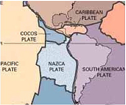
Nazca plate diagram, courtesy USGS
The results were obtained from precise global positioning satellite measurements taken before and after the quake, which occurred off the Maule coast of Chile, according to earth scientist Mike Bevis of Ohio State University. Since 1993, Bevis has headed the Central and Southern Andes GPS Project, designed to monitor crustal motion and deformation in the region. The project has detected surface displacements as far away as the Falkland Islands and Fortaleza, Brazil. Bevis and others are in Chile to install more GPS units at sites whose previous locations are accurately known and to monitor continued movement along the fault. The quake region is in the “ring of fire” that encircles the Pacific Ocean. The February tremor occurred when the Nazca tectonic plate, which lies under much of the Pacific Ocean, was forced under the South American tectonic plate, a process known as subduction. The lifting of the South American plate as it rode over the Nazca plate was responsible for the tidal wave that did considerable damage along the South American coast.
We use cookies to ensure that we give you the best experience on our website. If you continue to use this site we will assume that you are happy with it.