• Skip to primary navigation
  • Skip to main content
  • Skip to primary sidebar
  • Skip to secondary sidebar
  • Skip to footer
  • NEWS:
  • SatNews
  • SatMagazine
  • MilSatMagazine
  • SmallSat News
  • |     EVENTS:
  • SmallSat Symposium
  • Satellite Innovation
  • MilSat Symposium
  • SmallSat Europe

SatNews

Satellite Industry Intelligence Since 1983

Subscribe
  • LATEST
  • SatNews Events
  • Magazines
  • Calendar
  • Subscribe
  • Missions & Constellations
    • Exploration & Science Missions
    • In-Orbit Servicing & Orbital Operations
    • LEO Constellations
    • Mission Autonomy & Onboard Systems
    • Mission Deployments & Manifests
    • Navigation & PNT
    • SmallSat
    • Spacecraft & Payload Technology
    View All in Missions & Constellations →
    NanoAvionics to Launch Trio of Milestone Payloads on SpaceX CAS500-2 MissionNanoAvionics to Launch Trio of Milestone Payloads on SpaceX CAS500-2 Mission
    Satellite Connectivity Becomes the New Anchor for a Fragmenting Wearables MarketSatellite Connectivity Becomes the New Anchor for a Fragmenting Wearables Market
    AI Investments in Extreme Environment Materials Surpass $262 MillionAI Investments in Extreme Environment Materials Surpass $262 Million
    Air Inuit Modernizes Operations with SKYTRAC TrooTrax Mission SoftwareAir Inuit Modernizes Operations with SKYTRAC TrooTrax Mission Software
  • Business
    • Contracts & Commercial Deals
    • Earnings & Financial Reporting
    • Events & Conferences
    • Funding & Venture Capital
    • Market Forecasts
    • Mergers & Acquisitions
    • Personnel Moves & Appointments
    View All in Business & Finance →
    SmallSat Europe Speaker Focus: Dr. Jakob Stöber, McKinsey & CompanySmallSat Europe Speaker Focus: Dr. Jakob Stöber, McKinsey & Company
    Bright Ascension Finalizes Leadership Transition with John Baughn as CEOBright Ascension Finalizes Leadership Transition with John Baughn as CEO
    Global Invacom Secures Exclusive Worldwide Distribution for Prodelin Antenna RangeGlobal Invacom Secures Exclusive Worldwide Distribution for Prodelin Antenna Range
    HTX and ST Engineering Launch Space Tech Program for Singapore Public SafetyHTX and ST Engineering Launch Space Tech Program for Singapore Public Safety
  • Defense
    • Counterspace & ASAT
    • Defense Budgets & Procurement
    • ISR & Reconnaissance
    • MILSATCOM
    • Missile Warning & Defense
    • National Security Programs
    • Space Domain Awareness
    View All in Military & Defense →
    BAE Systems Enters Production for NavGuide M-Code GPS ReceiverBAE Systems Enters Production for NavGuide M-Code GPS Receiver
    Space Force Awards $3.2 Billion in Golden Dome Contracts for Orbital Interceptor ConstellationSpace Force Awards $3.2 Billion in Golden Dome Contracts for Orbital Interceptor Constellation
    USSF Finalizes GPS III Constellation with Successful SV-10 DeploymentUSSF Finalizes GPS III Constellation with Successful SV-10 Deployment
    Meink: Space Force Programs Ready to Execute Once FY27 Budget LandsMeink: Space Force Programs Ready to Execute Once FY27 Budget Lands
  • Gov
    • Export Controls & Compliance
    • International Space Agreements
    • National Space Policy
    • Space Law & Treaties
    • Space Sustainability & Debris Policy
    • Space Traffic Management / Debris Removal
    View All in Government & Regulation →
    SmallSat Europe Speaker Focus: Tanja Masson-Zwaan, Leiden UniversitySmallSat Europe Speaker Focus: Tanja Masson-Zwaan, Leiden University
    How CubeSat Proliferation is Redefining Sovereignty and Diplomatic Leverage at the United NationsHow CubeSat Proliferation is Redefining Sovereignty and Diplomatic Leverage at the United Nations
    FCC Modernization of Spectrum Rules Unlocks Sevenfold Gain in Satellite CapacityFCC Modernization of Spectrum Rules Unlocks Sevenfold Gain in Satellite Capacity
    The Smartest Money in the Room Is Looking UpThe Smartest Money in the Room Is Looking Up
  • Launch
    • Launch Providers
    • Launch Schedule & Calendars
    • Launch Sites & Infrastructure
    • Rocket Technology & Vehicles
    View All in Launch →
    Astrobotic Achieves Record 300-Second Burn with New Detonation EngineAstrobotic Achieves Record 300-Second Burn with New Detonation Engine
    Bad news, but good news followedBad news, but good news followed
    Rocket Lab Successfully Launches “Kakushin Rising” Mission for JAXARocket Lab Successfully Launches “Kakushin Rising” Mission for JAXA
    Blue Origin CEO Attributes BlueBird 7 Satellite Loss to Second-Stage Thrust AnomalyBlue Origin CEO Attributes BlueBird 7 Satellite Loss to Second-Stage Thrust Anomaly
  • Software
    • Autonomous Ground Operations
    • Data Processing & AI/ML
    • Digital Twins & Modeling
    • Ground Segment & Teleports
    • Mission Planning & Simulation
    • Space Systems Software Engineering
    • Spectrum & Licensing
    View All in Software Automation & Ground Systems →
    SmallSat Europe Speaker Focus: Giovanni Pandolfi Bortoletto, Leaf SpaceSmallSat Europe Speaker Focus: Giovanni Pandolfi Bortoletto, Leaf Space
    SpinLaunch Selects Equinix to Deploy Global Ground Infrastructure for Meridian Space ConstellationSpinLaunch Selects Equinix to Deploy Global Ground Infrastructure for Meridian Space Constellation
    RF-Design Launches FiberLink CompactLine FCLR1811S4 for Ground Segment OptimizationRF-Design Launches FiberLink CompactLine FCLR1811S4 for Ground Segment Optimization
    Sat-Lite Technologies adds  Richard Rader to Spearhead Sales ExpansionSat-Lite Technologies adds Richard Rader to Spearhead Sales Expansion
  • Services & Apps
    • Climate & Environmental Monitoring
    • Disaster Response & Security Mapping
    • Earth Observation & Imaging
    • Maritime & Aviation Satcom
    • Satellite Communications
    View All in Services & Applications →
    Solstar Confirms Successful On-Orbit Operation of Deke Space Communicator Following Launch on SpaceX Transporter-16 MissionSolstar Confirms Successful On-Orbit Operation of Deke Space Communicator Following Launch on SpaceX Transporter-16 Mission
    IEC Telecom Unveils Voucher-Based Connectivity Solution at Singapore Maritime Week 2026IEC Telecom Unveils Voucher-Based Connectivity Solution at Singapore Maritime Week 2026
    GomSpace and STETMAN Establish UASAT Joint Venture for Ukrainian Sovereign CommunicationsGomSpace and STETMAN Establish UASAT Joint Venture for Ukrainian Sovereign Communications
    Market Dynamics and Non-Terrestrial Network (NTN) ChipsetsMarket Dynamics and Non-Terrestrial Network (NTN) Chipsets

Purdue U’s Terrestrial Observatory Reconstructed in Egypt

January 14, 2009

Sat Image Purdue 
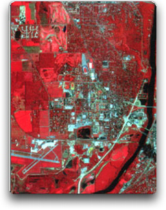
The Eqyptians will be constructing a facility modeled after Purdue University’s Terrestrial Observatory which will be used to provide early warning and mitigate the effects of disasters such as epidemics, famine and flooding to be built in Egypt as part of a NATO-funded effort. Courtesy of funding is provided by NATO through its Science for Peace and Security program, which creates partnerships among alliance countries and Eastern European, or so-called Mediterranean Dialogue nations, a forum of cooperation between seven countries centered in North Africa. Photo satellite image of Purdue

“The program promotes understanding and advances education and science,” said Gilbert Rochon, Information Technology at Purdue (ITaP) associate vice president for collaborative research. It also aims to yield practical results, in this case to provide meteorological and environmental data to countries within the region with the help of a powerful Geographic Information System.

Development of the Kamal Ewida Earth Observatory is being supported this year by about $78,000 from NATO. The project will receive another $315,000 in NATO funding over the next three years. Magdy Abdel Wahab, chair of the meteorology and astronomy department at Cairo University, will be the partner-country director.

“Purdue’s long experience with collecting, archiving and interpreting high-resolution satellite and other remotely sensed data made for a good model,” said Rochon, who heads the Purdue Terrestrial Observatory and will serve as NATO-country project director.

The project will largely recreate the Purdue Terrestrial Observatory, part of Purdue’s Rosen Center for Advanced Computing, and its remote sensing and analysis capabilities in Cairo, Egypt, to help identify and track natural and human-caused disasters. In cases like earthquakes and terrorism, it might be used to assess vulnerability and assist postdisaster reconstruction.

“For example, the information generated could help in planning for restoring power or repairing buildings after a quake,” said Rochon. He is working with Purdue colleague Okan Ersoy, along with Gamal El Afandi at Al Azhar University in Cairo and Gülay Atlay at Boğaziçi University’s Kandilli Observatory & Earthquake Research Institute in Istanbul, Turkey, in addition to Wahab.

Ersoy is a Purdue electrical and computer engineering professor. Part of his research focuses on remote sensing and applying machine learning and image processing techniques to get computers to analyze such data autonomously. “Using high-performance computing like that available through the Rosen Center, the system could provide nearly real-time interpretation of data and help the region react to disasters quickly,” Ersoy said.

Rochon, chief scientist for the Rosen Center, said the system also might be useful for sustainable development efforts, identifying from a vantage point in space, for instance, the spread of crop-damaging locusts and helping to better focus efforts to halt it in an environmentally friendly manner.

The Purdue Terrestrial Observatory gathers masses of satellite, radar and other remote-sensing data, as well as information collected on the ground. The observatory assists researchers on campus and internationally in an interdisciplinary array of fields who mine remote-sensing data and work to develop techniques for employing remote sensing in early detection and mitigation of disasters. The center also makes data available to researchers and decision-makers from the local to national levels, and the agricultural sector, to use in Geographic Information Systems.

Filed Under: Disaster Response & Security Mapping

Primary Sidebar

Coverage

  • Missions & Constellations
  • Business & Finance
  • Military & Defense
  • Launch
  • Software Automation & Ground Systems
  • Government & Regulation
  • Services & Applications

Most Read Stories

  • SpaceX Loses Contact With Starlink Satellite
  • Planet Labs Imposes Indefinite Blackout on Iran Satellite Imagery at U.S. Request
  • Amazon in Reported Talks to Acquire Globalstar in $9 Billion Move to Challenge Starlink
  • What the SpaceX IPO Changes for Every Satellite Operator
  • Russia Replaces Starlink With European-Built Satellites

Secondary Sidebar

Footer


Satnews is a leading provider of satellite news, events, publications, research and other satellite industry information in both commercial and military enterprises worldwide.

Stories By Category

  • Business & Finance
  • Government & Regulation
  • Launch
  • Military & Defense
  • Missions & Constellations
  • Services & Applications
  • Software Automation & Ground Systems
  • Spectrum & Licensing
  • Startups & NewSpace Business

About Us

  • Leadership & Editorial Team
  • SatNews History
  • Free Satnews Subscription
  • SatNews Events
  • Magazines

Navigation

  • Latest Stories
  • Magazines
  • Events
  • Contact
  • Cookie & Privacy Policy for Satnews

We use cookies to ensure that we give you the best experience on our website. If you continue to use this site we will assume that you are happy with it.
x
Sign up Now (For Free)
Access daily or weekly satellite news updates covering all aspects of the commercial and military satellite industry.
Invalid email address
Notify Me Regarding ( At least one ):
We value your privacy and will not sell or share your email or other information with any other company. You may also unsubscribe at anytime.

Click Here to see our full privacy policy.
Thanks for subscribing!