• Skip to primary navigation
  • Skip to main content
  • Skip to primary sidebar
  • Skip to secondary sidebar
  • Skip to footer
  • NEWS:
  • SatNews
  • SatMagazine
  • MilSatMagazine
  • SmallSat News
  • |     EVENTS:
  • SmallSat Symposium
  • Satellite Innovation
  • MilSat Symposium
  • SmallSat Europe

SatNews

Satellite Industry Intelligence Since 1983

Subscribe
  • LATEST
  • SatNews Events
  • Magazines
  • Calendar
  • Subscribe
  • Missions & Constellations
    • Exploration & Science Missions
    • In-Orbit Servicing & Orbital Operations
    • LEO Constellations
    • Mission Autonomy & Onboard Systems
    • Mission Deployments & Manifests
    • Navigation & PNT
    • SmallSat
    • Spacecraft & Payload Technology
    View All in Missions & Constellations →
    Hybrid Cabin Architecture: Mapping the Next Generation of In-Flight Connectivity (IFC)Hybrid Cabin Architecture: Mapping the Next Generation of In-Flight Connectivity (IFC)
    Fleet-Wide Hybrid Networks: Marlink Integrates Starlink Across 80+ Oldendorff Carriers VesselsFleet-Wide Hybrid Networks: Marlink Integrates Starlink Across 80+ Oldendorff Carriers Vessels
    Navigating Contested Battlespaces: Military GPS Receiver Market Approaches $3 Billion Amid Electronic Warfare SurgeNavigating Contested Battlespaces: Military GPS Receiver Market Approaches $3 Billion Amid Electronic Warfare Surge
    Atmospheric Alignment: NASA Greenlights DAPHNE Mission to Map the Edge of Space WeatherAtmospheric Alignment: NASA Greenlights DAPHNE Mission to Map the Edge of Space Weather
  • Business
    • Contracts & Commercial Deals
    • Earnings & Financial Reporting
    • Events & Conferences
    • Funding & Venture Capital
    • Market Forecasts
    • Mergers & Acquisitions
    • Personnel Moves & Appointments
    View All in Business & Finance →
    Ghost Viewers trigger secondary ripple effect on Satellite Communications (SatCom)Ghost Viewers trigger secondary ripple effect on Satellite Communications (SatCom)
    Lightpath expands fiber footprint as demand for AI-ready connectivity infrastructure acceleratesLightpath expands fiber footprint as demand for AI-ready connectivity infrastructure accelerates
    Hybrid Expansion: SES Launches Next-Gen Set-Top Boxes and Multi-Region Channel Pack for ASTRA TV in SpainHybrid Expansion: SES Launches Next-Gen Set-Top Boxes and Multi-Region Channel Pack for ASTRA TV in Spain
    Underground Maneuver: Traysar Emerges From Stealth With $25M Seed Round to Modernize Subterranean WarfareUnderground Maneuver: Traysar Emerges From Stealth With $25M Seed Round to Modernize Subterranean Warfare
  • Defense
    • Counterspace & ASAT
    • Defense Budgets & Procurement
    • ISR & Reconnaissance
    • MILSATCOM
    • Missile Warning & Defense
    • National Security Programs
    • Space Domain Awareness
    View All in Military & Defense →
    The Strategic Redistribution of Iranian Aerospace CapabilityThe Strategic Redistribution of Iranian Aerospace Capability
    Preparing for Day One: DARPA Solicits Tech to Rebuild Destroyed Satellite Fleets Within HoursPreparing for Day One: DARPA Solicits Tech to Rebuild Destroyed Satellite Fleets Within Hours
    Sovereign Space Expansion: Portugal Procures Dual ICEYE Radar Satellites to Broaden Maritime SurveillanceSovereign Space Expansion: Portugal Procures Dual ICEYE Radar Satellites to Broaden Maritime Surveillance
    Space Force Awards Lockheed Martin $514M to Build Resilient GPS IIIF SatellitesSpace Force Awards Lockheed Martin $514M to Build Resilient GPS IIIF Satellites
  • Gov
    • Export Controls & Compliance
    • International Space Agreements
    • National Space Policy
    • Space Law & Treaties
    • Space Sustainability & Debris Policy
    • Space Traffic Management / Debris Removal
    View All in Government & Regulation →
    Who Has Authority to Intervene in a Space-Based Emergency?Who Has Authority to Intervene in a Space-Based Emergency?
    Staying in Their Lanes: SpaceX and Globalstar Join Forces to Defend Spectrum ExclusivityStaying in Their Lanes: SpaceX and Globalstar Join Forces to Defend Spectrum Exclusivity
    Orbital Paperwork War: China’s Spectrum Squatting Reserves 244,000 Satellite Slots to Combat SpaceX’s LEO MonopolyOrbital Paperwork War: China’s Spectrum Squatting Reserves 244,000 Satellite Slots to Combat SpaceX’s LEO Monopoly
    The Next Arena: Why the WRC-27 Summit in Shanghai is the New Space Tech FrontlineThe Next Arena: Why the WRC-27 Summit in Shanghai is the New Space Tech Frontline
  • Launch
    • Launch Providers
    • Launch Schedule & Calendars
    • Launch Sites & Infrastructure
    • Rocket Technology & Vehicles
    View All in Launch →
    Arianespace fights back – possibly!Arianespace fights back – possibly!
    Direct-to-Device Momentum: AST SpaceMobile Successfully Launches Giant Next-Gen BlueBird Satellites Atop SpaceX Falcon 9Direct-to-Device Momentum: AST SpaceMobile Successfully Launches Giant Next-Gen BlueBird Satellites Atop SpaceX Falcon 9
    SpaceX’s Secret ‘Starfall’ Capsule Wins FAA Approval for Pacific Reentry TestsSpaceX’s Secret ‘Starfall’ Capsule Wins FAA Approval for Pacific Reentry Tests
    Breaking the TRL Bottleneck: Space Phoenix Systems Debuts Cost-Effective Space Test-and-Return ServiceBreaking the TRL Bottleneck: Space Phoenix Systems Debuts Cost-Effective Space Test-and-Return Service
  • Software
    • Autonomous Ground Operations
    • Data Processing & AI/ML
    • Digital Twins & Modeling
    • Ground Segment & Teleports
    • Mission Planning & Simulation
    • Space Systems Software Engineering
    • Spectrum & Licensing
    View All in Software Automation & Ground Systems →
    Powering the Automated Floor: Intralogistics Operators Must Unify AGV Charging InfrastructurePowering the Automated Floor: Intralogistics Operators Must Unify AGV Charging Infrastructure
    Poland Sovereignty: GMV to Develop Core Ground Control Platform for CAMILA ConstellationPoland Sovereignty: GMV to Develop Core Ground Control Platform for CAMILA Constellation
    Software Over the Air: FatPipe Launches Acceleration Tool to Unclog Starlink and Amazon LEO LinksSoftware Over the Air: FatPipe Launches Acceleration Tool to Unclog Starlink and Amazon LEO Links
    Three LEO Operators Bet 2026 on a Supply Chain Built for 2027Three LEO Operators Bet 2026 on a Supply Chain Built for 2027
  • Services & Apps
    • Climate & Environmental Monitoring
    • Disaster Response & Security Mapping
    • Earth Observation & Imaging
    • Maritime & Aviation Satcom
    • Satellite Communications
    View All in Services & Applications →
    Fragmentation Over Funds: Why System Disconnection, Not Under-Investment, Is Maritime’s True Cyber ThreatFragmentation Over Funds: Why System Disconnection, Not Under-Investment, Is Maritime’s True Cyber Threat
    U.S. viewership of the 2026 World Cup via satellite television is strong and easily accessibleU.S. viewership of the 2026 World Cup via satellite television is strong and easily accessible
    Space-Based Underwriting: Liberty and ICEYE Launch Satellite-Powered Parametric Wildfire InsuranceSpace-Based Underwriting: Liberty and ICEYE Launch Satellite-Powered Parametric Wildfire Insurance
    Rapid Deployment: ZeroUSV Streamlines Uncrewed Vessel Portability for Defense and Survey MissionsRapid Deployment: ZeroUSV Streamlines Uncrewed Vessel Portability for Defense and Survey Missions

Ribbon Is Cut as NASA and USAID SERVIR-Africa

November 24, 2008

SERVIR photo Kenya 
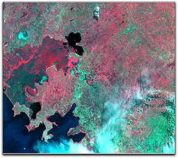
Good news that should provide positive changes as NASA, the U.S. Agency for International Development (USAID) and their international partners cut the ribbon Friday in Nairobi, Kenya, for SERVIR-Africa which integrates the satellite resources of the United States and other countries into a Web-based Earth information system. This effort puts previously inaccessible information into the hands of local scientists, government leaders and communities to help address concerns related to natural disasters, disease outbreaks, biodiversity and climate change. The Nzoia River basin lies entirely within the Lake Victoria basin in Kenya. The SERVIR-Africa team captured multispectral imagery of the Nzoia River basin from the NASA’s EO-1 satellite on August 23, 2008 to provide baseline imagery of this frequently flooded area for future analysis. Credit: NASA/EO-1

SERVIR, Spanish for “to serve,” has been in operation in Central America, the Caribbean and southern Mexico since 2005. Now, through the support of multiple government agencies and other organizations, NASA and USAID are expanding the system to Africa in partnership with the Regional Center for Mapping of Resources for Development in Nairobi. The center, an intergovernmental organization with 15 member states in eastern and southern Africa, is a leader in geospatial mapping in the region.

“A satellite birds-eye view can provide an overall picture of a natural disaster, such as a flood, and its consequences,” said Tesfaye Korme, director of remote sensing and geographic information systems at the center. “Using the SERVIR-Africa platform, we will be able to develop near-real time maps of flood-affected areas to estimate the number of displaced people and locate potential transportation disruptions.”

SERVIR-Africa will use Earth science satellite data from many of NASA’s missions and other information to better predict areas at risk for severe flooding and map regions hit by floods. It also will develop an early-warning tool to predict the distribution of vector-borne diseases such as Rift Valley Fever. By mapping the location of climate change projections, the system will allow people to see impacts on such things as Africa’s diverse ecosystems.

SERVIR-Africa’s information technology team will use the Internet to acquire and distribute satellite and ground-based Earth observations, map data, and geospatial analyses that target issues such as urbanization, biodiversity threats, and management of natural resources. “SERVIR-Africa will benefit from the breadth and depth of valuable NASA Earth science satellite and model analyses,” said Dan Irwin, SERVIR project director at NASA’s Marshall Space Flight Center in Huntsville, Alabama. “Science and technology are key, but ultimately it is the combination of local knowledge along with space-based observations that makes real time monitoring of Africa’s environment effective.”

The strength of the SERVIR system is in its diverse international team of scientists, developers and researchers. SERVIR-Africa builds on existing capacity at the mapping center in Nairobi. The center, together with SERVIR’s lead partner in Central America, the Water Center for the Humid Tropics of Latin America and the Caribbean, are jointly developing an integrated system. These two regional organizations are standardizing database management and evaluating common methods for predicting severe weather events, analyzing impacts from climate change and working to understand health and ecosystem interactions.

SERVIR also has been building relationships with industry. “Public-private partnerships are critical to the success of the SERVIR system,” said Jacqueline E. Schafer of USAID. “Bringing together the expertise and resources of geospatial information systems software and cell phone companies, university researchers, conservation organizations, and governments, SERVIR puts science and technology into the hands of local decision-makers.”

The SERVIR system was developed with USAID by researchers at a global coordination office and rapid prototyping facility at Marshall. Three other NASA centers; NASA’s Goddard Space Flight Center in Greenbelt, Maryland, NASA’s Ames Research Center at Moffet Field, California, and NASA’s Jet Propulsion Laboratory in Pasadena, California partnered with Marshall on the system. Also participating in the implementation of SERVIR-Africa is the Institute for the Application of Geospatial Technology in Auburn, N.Y.

Filed Under: Climate & Environmental Monitoring, Earth Observation & Imaging

Primary Sidebar

Coverage

  • Missions & Constellations
  • Business & Finance
  • Military & Defense
  • Launch
  • Software Automation & Ground Systems
  • Government & Regulation
  • Services & Applications

Most Read Stories

  • SpaceX: 10,000 Launches Annually
  • American military space closed around one company in seven days
  • SpaceX’s Secret ‘Starfall’ Capsule Wins FAA Approval for Pacific Reentry Tests
  • Analyst Projects Massive Subscription Growth for Starlink Ahead of Imminent SpaceX IPO
  • Major opportunities for 2 GHz over Europe

Secondary Sidebar

Footer


Satnews is a leading provider of satellite news, events, publications, research and other satellite industry information in both commercial and military enterprises worldwide.

Stories By Category

  • Business & Finance
  • Government & Regulation
  • Launch
  • Military & Defense
  • Missions & Constellations
  • Services & Applications
  • Software Automation & Ground Systems
  • Spectrum & Licensing
  • Startups & NewSpace Business

About Us

  • Leadership & Editorial Team
  • SatNews History
  • Free Satnews Subscription
  • SatNews Events
  • Magazines

Navigation

  • Latest Stories
  • Magazines
  • Events
  • Contact
  • Cookie & Privacy Policy for Satnews

We use cookies to ensure that we give you the best experience on our website. If you continue to use this site we will assume that you are happy with it.
x
Sign up Now (For Free)
Access daily or weekly satellite news updates covering all aspects of the commercial and military satellite industry.
Invalid email address
Notify Me Regarding ( At least one ):
We value your privacy and will not sell or share your email or other information with any other company. You may also unsubscribe at anytime.

Click Here to see our full privacy policy.
Thanks for subscribing!