• Skip to primary navigation
  • Skip to main content
  • Skip to primary sidebar
  • Skip to secondary sidebar
  • Skip to footer
  • NEWS:
  • SatNews
  • SatMagazine
  • MilSatMagazine
  • SmallSat News
  • |     EVENTS:
  • SmallSat Symposium
  • Satellite Innovation
  • MilSat Symposium
  • SmallSat Europe

SatNews

Satellite Industry Intelligence Since 1983

Subscribe
  • LATEST
  • SatNews Events
  • Magazines
  • Calendar
  • Subscribe
  • Missions & Constellations
    • Exploration & Science Missions
    • In-Orbit Servicing & Orbital Operations
    • LEO Constellations
    • Mission Autonomy & Onboard Systems
    • Mission Deployments & Manifests
    • Navigation & PNT
    • SmallSat
    • Spacecraft & Payload Technology
    View All in Missions & Constellations →
    Viasat Completes ViaSat-3 Constellation with Successful Flight 3 LaunchViasat Completes ViaSat-3 Constellation with Successful Flight 3 Launch
    GMV to Lead Mission Planning for ESA’s Next-Generation Copernicus ExpansionGMV to Lead Mission Planning for ESA’s Next-Generation Copernicus Expansion
    Canada Tightens Re-entry Regulations as SpaceX Starlink Constellations DescendCanada Tightens Re-entry Regulations as SpaceX Starlink Constellations Descend
    The waiver was the policy. Thursday is the paperwork.The waiver was the policy. Thursday is the paperwork.
  • Business
    • Contracts & Commercial Deals
    • Earnings & Financial Reporting
    • Events & Conferences
    • Funding & Venture Capital
    • Market Forecasts
    • Mergers & Acquisitions
    • Personnel Moves & Appointments
    View All in Business & Finance →
    SmallSat Europe Speaker Focus: Koen Willems, ST Engineering iDirect EuropeSmallSat Europe Speaker Focus: Koen Willems, ST Engineering iDirect Europe
    U.S. Commercial Service to Host “Future in Orbit” Networking Event at SpaceBR 2026U.S. Commercial Service to Host “Future in Orbit” Networking Event at SpaceBR 2026
    SmallSat Europe Speaker Focus: Dr. Jakob Stöber, McKinsey & CompanySmallSat Europe Speaker Focus: Dr. Jakob Stöber, McKinsey & Company
    Bright Ascension Finalizes Leadership Transition with John Baughn as CEOBright Ascension Finalizes Leadership Transition with John Baughn as CEO
  • Defense
    • Counterspace & ASAT
    • Defense Budgets & Procurement
    • ISR & Reconnaissance
    • MILSATCOM
    • Missile Warning & Defense
    • National Security Programs
    • Space Domain Awareness
    View All in Military & Defense →
    BAE Systems Enters Production for NavGuide M-Code GPS ReceiverBAE Systems Enters Production for NavGuide M-Code GPS Receiver
    Space Force Awards $3.2 Billion in Golden Dome Contracts for Orbital Interceptor ConstellationSpace Force Awards $3.2 Billion in Golden Dome Contracts for Orbital Interceptor Constellation
    USSF Finalizes GPS III Constellation with Successful SV-10 DeploymentUSSF Finalizes GPS III Constellation with Successful SV-10 Deployment
    Meink: Space Force Programs Ready to Execute Once FY27 Budget LandsMeink: Space Force Programs Ready to Execute Once FY27 Budget Lands
  • Gov
    • Export Controls & Compliance
    • International Space Agreements
    • National Space Policy
    • Space Law & Treaties
    • Space Sustainability & Debris Policy
    • Space Traffic Management / Debris Removal
    View All in Government & Regulation →
    SmallSat Europe Speaker Focus: Tanja Masson-Zwaan, Leiden UniversitySmallSat Europe Speaker Focus: Tanja Masson-Zwaan, Leiden University
    How CubeSat Proliferation is Redefining Sovereignty and Diplomatic Leverage at the United NationsHow CubeSat Proliferation is Redefining Sovereignty and Diplomatic Leverage at the United Nations
    FCC Modernization of Spectrum Rules Unlocks Sevenfold Gain in Satellite CapacityFCC Modernization of Spectrum Rules Unlocks Sevenfold Gain in Satellite Capacity
    The Smartest Money in the Room Is Looking UpThe Smartest Money in the Room Is Looking Up
  • Launch
    • Launch Providers
    • Launch Schedule & Calendars
    • Launch Sites & Infrastructure
    • Rocket Technology & Vehicles
    View All in Launch →
    FAA Grounds Blue Origin Following New Glenn Upper Stage Failure and Facility AnomalyFAA Grounds Blue Origin Following New Glenn Upper Stage Failure and Facility Anomaly
    NanoAvionics to Launch Trio of Milestone Payloads on SpaceX CAS500-2 MissionNanoAvionics to Launch Trio of Milestone Payloads on SpaceX CAS500-2 Mission
    Astrobotic Achieves Record 300-Second Burn with New Detonation EngineAstrobotic Achieves Record 300-Second Burn with New Detonation Engine
    Bad news, but good news followedBad news, but good news followed
  • Software
    • Autonomous Ground Operations
    • Data Processing & AI/ML
    • Digital Twins & Modeling
    • Ground Segment & Teleports
    • Mission Planning & Simulation
    • Space Systems Software Engineering
    • Spectrum & Licensing
    View All in Software Automation & Ground Systems →
    Global Invacom Secures Exclusive Worldwide Distribution for Prodelin Antenna RangeGlobal Invacom Secures Exclusive Worldwide Distribution for Prodelin Antenna Range
    SmallSat Europe Speaker Focus: Giovanni Pandolfi Bortoletto, Leaf SpaceSmallSat Europe Speaker Focus: Giovanni Pandolfi Bortoletto, Leaf Space
    SpinLaunch Selects Equinix to Deploy Global Ground Infrastructure for Meridian Space ConstellationSpinLaunch Selects Equinix to Deploy Global Ground Infrastructure for Meridian Space Constellation
    RF-Design Launches FiberLink CompactLine FCLR1811S4 for Ground Segment OptimizationRF-Design Launches FiberLink CompactLine FCLR1811S4 for Ground Segment Optimization
  • Services & Apps
    • Climate & Environmental Monitoring
    • Disaster Response & Security Mapping
    • Earth Observation & Imaging
    • Maritime & Aviation Satcom
    • Satellite Communications
    View All in Services & Applications →
    Solstar Confirms Successful On-Orbit Operation of Deke Space Communicator Following Launch on SpaceX Transporter-16 MissionSolstar Confirms Successful On-Orbit Operation of Deke Space Communicator Following Launch on SpaceX Transporter-16 Mission
    IEC Telecom Unveils Voucher-Based Connectivity Solution at Singapore Maritime Week 2026IEC Telecom Unveils Voucher-Based Connectivity Solution at Singapore Maritime Week 2026
    GomSpace and STETMAN Establish UASAT Joint Venture for Ukrainian Sovereign CommunicationsGomSpace and STETMAN Establish UASAT Joint Venture for Ukrainian Sovereign Communications
    Market Dynamics and Non-Terrestrial Network (NTN) ChipsetsMarket Dynamics and Non-Terrestrial Network (NTN) Chipsets

The Flying Eyeball Evolves From NASA

November 5, 2008

eclipse 
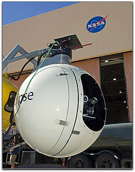
NASA is developing technologies that will allow lunar landers to automatically identify and navigate to the location of a safe landing site while detecting landing hazards during the final descent to the surface. This is important because future lunar missions will need this capability to be able to land safely near specific resources that are located in potentially hazardous terrain. A variety of lenses used by the gimbal-mounted lidar device are visible through the opening in its ball-shaped housing. Credit: NASA/Tony Landis

Two critical sensor technologies being developed by NASA Langley Research Center will enable this capability. One is a three-dimensional active imaging device for measuring the topography of a landing area. The second is a device for measuring speed to help land precisely at the chosen site.

To help meet this dual challenge, Langley has designed two special-purpose light detection and ranging (lidar) sensors. In conjunction with this, NASA’s Jet Propulsion Laboratory is developing algorithms, or mathematical procedures, for analyzing the terrain based upon these lidar measurements. These technologies have been integrated as part of NASA’s Autonomous Landing and Hazard Avoidance Technology (ALHAT) project and are in the process of being demonstrated in a series of flight tests. Bob Reisse is leading a Langley team designing the lidar sensors and supporting the demonstration flight tests. “We were pleased that the two flight tests we’ve conducted so far have resulted in better than expected performance of these sensors. The main objective of the first test, carried out in May, was to demonstrate the application of 3-D imaging technology or ‘flash’ lidar, for topography mapping and precision navigation.

“The second round of flight tests, completed in August, was to evaluate the capabilities of an emerging lidar technology developed at Langley, called the Doppler lidar velocimeter, also needed to meet ALHAT’s stringent need for precision navigation. This lidar provides vehicle velocity vector, altitude and attitude with a very high degree of precision,” Reisse said.

heli and eclipse 
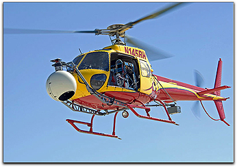
During this most recent test, the velocimeter was carried aloft at NASA’s Dryden Flight Research Center via helicopter which flew a total of six flights at various altitudes between targeted reference points. During the tests, the helicopter flew over two target areas three miles (5 km) apart on the surface of Rogers Dry Lake. Repeated back-and-forth tracks were flown at altitudes incrementally increasing from about 300 feet to 6,200 feet (91m to 1,890m) above the lake bed while the lidar measured the relative speed, altitude, and attitude of the helicopter. Plywood circles placed on the lakebed served as reference targets for determining the ground “truth” measurements. The data was recorded on board and tagged with time and altitude information to allow post-flight processing. A sophisticated lidar device designed to detect potential landing site hazards for future autonomous lunar landers projects from the nose of a helicopter during August flight tests at NASA Dryden. Credit: NASA/Tony Landis

Lidar technology promises great improvements over current state-of-the-art systems for planetary navigating tasks. Preliminary results with the ALHAT Doppler lidar indicate that its “accuracy of velocity” readings and “rate of updates” are more than 10 times higher than conventional Doppler radar-based sensors like those used in Phoenix Mars Lander and Mars Science Lab. Precision range and directional velocity data are critical to navigating lunar landing vehicles to the pre-selected site and achieving autonomous, safe soft-landing. Data provided by ALHAT’s lidar can significantly impact the design of future lunar and other planetary landing missions. The technology also has potential for aiding crew exploration vehicle rendezvous and docking, and Earth reentry landing systems.

NASA’s Johnson Space Center leads the nine-year ALHAT task, begun in early 2006, for NASA’s Exploration Technology Development Program. Support is also provided by Charles Stark Draper Labs and the Johns Hopkins Applied Physics Laboratory, Baltimore, Maryland.  

Filed Under: Exploration & Science Missions, Mission Autonomy & Onboard Systems

Primary Sidebar

Coverage

  • Missions & Constellations
  • Business & Finance
  • Military & Defense
  • Launch
  • Software Automation & Ground Systems
  • Government & Regulation
  • Services & Applications

Most Read Stories

  • Planet Labs Imposes Indefinite Blackout on Iran Satellite Imagery at U.S. Request
  • Amazon in Reported Talks to Acquire Globalstar in $9 Billion Move to Challenge Starlink
  • What the SpaceX IPO Changes for Every Satellite Operator
  • Russia Replaces Starlink With European-Built Satellites
  • The Downlink Deficit: The Pentagon's Optical Mesh Network and the Terrestrial Bottleneck

Secondary Sidebar

Footer


Satnews is a leading provider of satellite news, events, publications, research and other satellite industry information in both commercial and military enterprises worldwide.

Stories By Category

  • Business & Finance
  • Government & Regulation
  • Launch
  • Military & Defense
  • Missions & Constellations
  • Services & Applications
  • Software Automation & Ground Systems
  • Spectrum & Licensing
  • Startups & NewSpace Business

About Us

  • Leadership & Editorial Team
  • SatNews History
  • Free Satnews Subscription
  • SatNews Events
  • Magazines

Navigation

  • Latest Stories
  • Magazines
  • Events
  • Contact
  • Cookie & Privacy Policy for Satnews

We use cookies to ensure that we give you the best experience on our website. If you continue to use this site we will assume that you are happy with it.
x
Sign up Now (For Free)
Access daily or weekly satellite news updates covering all aspects of the commercial and military satellite industry.
Invalid email address
Notify Me Regarding ( At least one ):
We value your privacy and will not sell or share your email or other information with any other company. You may also unsubscribe at anytime.

Click Here to see our full privacy policy.
Thanks for subscribing!