

Airbus' ocean satellite, ‘Copernicus Sentinel-6A’, is ready to begin its first journey ... not to space just yet, but to Ottobrunn near Munich in Germany, where over the next six months the satellite will undergo an extensive series of tests at Industrieanlagen Betriebsgesellschaft mbH(IABG) to prove its readiness for space. The launch to space is set for November 2020.
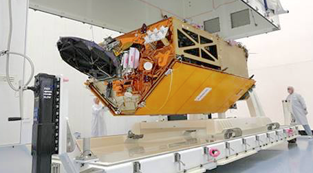
Airbus has completed the ocean satellite ‘Copernicus Sentinel-6A’. Photo: Airbus / Lorenz Engelhardt
‘Copernicus Sentinel-6’ will carry out high-precision measurements of ocean surface topography. The satellite will measure its distance to the ocean surface with an accuracy of a few centimeters and, on a mission lasting up to seven years, use this data to map it, repeating the cycle every 10 days. It will document changes in sea-surface height, record and analyze variations in sea levels and observe ocean currents. Exact observations of changes in sea-surface height provide insights into global sea levels, the speed and direction of ocean currents, and ocean heat storage. These measurements are vital for modeling the oceans and predicting rises in sea levels.
The findings will enable governments and institutions to establish effective protection for coastal regions. The data will be invaluable not only for disaster relief organizations, but also for authorities involved in urban planning, securing buildings or commissioning dikes. This information is also helpful with changing sea levels and those countries with densely populated coastal areas.
Two Sentinel-6 satellites for the European Copernicus Program for environment and security are currently being developed under Airbus’s industrial While it is one of the European Union’s family of Copernicus satellite missions, Sentinel-6 is also being realized thanks to an international cooperation between ESA, NASA, NOAA and Eumetsat.
Each satellite weighs approximately 1.5 tonnes. From November 2020, Sentinel-6A will be the first of the two Sentinel-6 satellites to continue collecting satellite-based measurements of the oceans’ surfaces, a task that began in 1992. Sentinel-6B is then expected to follow in 2025.