
The commercial Earth observation market is undergoing a structural shift in how sovereign states and heavy industries procure space assets. Historically, acquiring satellite intelligence required either purchasing restrictive, expensive data packets from third-party brokers or absorbing the massive capital expenditures (CAPEX) needed to build and launch a proprietary orbital fleet.
To bypass these traditional capital constraints, international remote sensing provider Starpath Global (Chinese: 寰球星途, Huanqiu Xingtu) has expanded its end-to-end “Satellite-as-a-Service” model. By pairing custom spacecraft engineering with an innovative financial leasing framework, the company allows commercial enterprises and regional governments to operate dedicated, customizable satellite capacities with minimal upfront capital investment.
A Full-Chain Spatial Infrastructure Ecosystem
Headquartered in Shanghai’s Xuhui District, Starpath Global has strategically built a distributed network across China’s primary technology and trade hubs, including specialized engineering and software data delivery centers in Hangzhou, Beijing, Shenzhen, and Hong Kong.
Rather than functioning solely as a downstream data reseller, Starpath Global operates as a full-chain aerospace prime. The company directly manages the entire lifecycle of the space asset—encompassing initial mission design, hardware manufacturing, launch manifestation, ground teleport routing, and in-orbit fleet management. This tight vertical integration enables the company to offer highly predictable customization paths for clients requiring tailored orbital parameters or specialized instrumentation payloads.
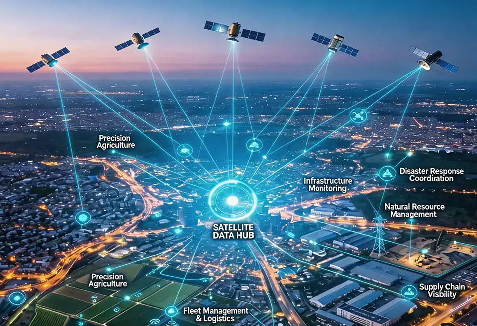
Multi-Sensor Virtual Constellation and High-Revisit Metrics
The operational backbone of Starpath Global’s service delivery relies on a robust virtual constellation comprising more than 100 satellites. This high-density orbital mesh provides an elite 24-hour revisit capability, ensuring that any geographic coordinate on the globe can be imaged and analyzed on a daily basis.
To capture high-fidelity physical data through changing weather conditions and darkness, the constellation utilizes a tiered, multi-sensor payload architecture:
- Sub-Meter Optical Arrays: Delivers ultra-high-resolution visible light imagery peaking at a 0.3-meter maximum resolution, optimized for precise structural monitoring, urban planning, and tactical security analysis.
- Synthetic Aperture Radar (SAR): Deploys cloud-penetrating, day-and-night active radar sensors to maintain uninterrupted infrastructure tracking over regions plagued by persistent cloud cover, wildfire smoke, or heavy fog.
- Hyperspectral and Multi-Spectral Scanners: Divides the electromagnetic spectrum into hundreds of continuous, narrow bands, capturing the specific chemical, molecular, and material signatures of surface features.
Translating Spectral Barcodes into Industrial Intelligence
By leveraging continuous hyperspectral scanning, Starpath Global transforms simple imagery into highly specialized geospatial intelligence for commodity markets and heavy engineering sectors. This capability acts like a remote chemical analysis tool operating from low Earth orbit, allowing industries to audit wide-scale operations automatically.
The primary industrial application vectors focus on high-stakes resource and infrastructure management:
- Precision Agriculture: The platform automatically calculates vegetation indices, maps soil moisture variations, tracks localized crop disease vectors, and monitors nitrogen absorption to generate predictive regional yield models for global food supply chains.
- Mining and Material Logistics: Hyperspectral analytics allow mining firms to perform autonomous surface mineral mapping, monitor the structural integrity of remote tailings dams, and conduct automated volumetric calculations of extracted ore stockpiles.
- Energy and Pipeline Infrastructure: Continuous thermal and infrared monitoring enables oil and gas utilities to detect high-risk methane emissions, isolate sub-surface pipeline leaks via thermal anomalies, and plan logistically optimized routes through challenging topography.
- Environmental & Maritime Intelligence: Real-time port congestion tracking, automated ship classification, and rapid ecological damage mapping support the precision requirements of international insurance underwriting and disaster response frameworks.
The Shift Toward Decentralized Orbital Access
As the space economy moves rapidly toward integration with terrestrial cloud architectures, the ability to flexibly lease space hardware is emerging as a critical competitive advantage. Starpath Global’s financial leasing structure treats satellite access as an operational expense (OPEX), opening the space domain to mid-tier industrial players and developing nations.
By eliminating the necessity of managing complex launch supply chains or enduring multi-year hardware lead times, the model ensures that high-cadence, unjammable Earth intelligence scales directly with the real-time demands of the global economy.