


• Skip to primary navigation
  • Skip to main content
  • Skip to primary sidebar
  • Skip to secondary sidebar
  • Skip to footer
  • NEWS:
  • SatNews
  • SatMagazine
  • MilSatMagazine
  • SmallSat News
  • |     EVENTS:
  • SmallSat Symposium
  • Satellite Innovation
  • MilSat Symposium
  • SmallSat Europe

SatNews

Satellite Industry Intelligence Since 1983

Subscribe
  • LATEST
  • SatNews Events
  • Magazines
  • Calendar
  • Subscribe
  • Missions & Constellations
    • Exploration & Science Missions
    • In-Orbit Servicing & Orbital Operations
    • LEO Constellations
    • Mission Autonomy & Onboard Systems
    • Mission Deployments & Manifests
    • Navigation & PNT
    • SmallSat
    • Spacecraft & Payload Technology
    View All in Missions & Constellations →
    NASA and ISISPACE Deploy GRITSS CubeSat to Advance Orbital Reference Frame PrecisionNASA and ISISPACE Deploy GRITSS CubeSat to Advance Orbital Reference Frame Precision
    Momentus Vigoride 7 Completes Orbital Altitude Adjustments as Hosted Payload Testing ProgressesMomentus Vigoride 7 Completes Orbital Altitude Adjustments as Hosted Payload Testing Progresses
    Astro Digital Selects Everspin 64Mb STT-MRAM for Raven Bus Geosynchronous Satellite ProgramAstro Digital Selects Everspin 64Mb STT-MRAM for Raven Bus Geosynchronous Satellite Program
    Launch Manifests Are Becoming Spectrum PolicyLaunch Manifests Are Becoming Spectrum Policy
  • Business
    • Contracts & Commercial Deals
    • Earnings & Financial Reporting
    • Events & Conferences
    • Funding & Venture Capital
    • Market Forecasts
    • Mergers & Acquisitions
    • Personnel Moves & Appointments
    View All in Business & Finance →
    Silicon Valley Space Week Speaker Focus: Col. Timothy Trimailo, Space Systems CommandSilicon Valley Space Week Speaker Focus: Col. Timothy Trimailo, Space Systems Command
    AccelerComm Powers Eclipse Space 5G Physical Layer Architecture for Sovereign Satellite ConstellationsAccelerComm Powers Eclipse Space 5G Physical Layer Architecture for Sovereign Satellite Constellations
    Farnborough International Airshow Pivot Driven by Soaring Global Defense SpendingFarnborough International Airshow Pivot Driven by Soaring Global Defense Spending
    Global Konet and Hanseo University Partner to Develop Integrated 100 km BVLOS Satellite Communication Infrastructure for DronesGlobal Konet and Hanseo University Partner to Develop Integrated 100 km BVLOS Satellite Communication Infrastructure for Drones
  • Defense
    • Counterspace & ASAT
    • Defense Budgets & Procurement
    • ISR & Reconnaissance
    • MILSATCOM
    • Missile Warning & Defense
    • National Security Programs
    • Space Domain Awareness
    View All in Military & Defense →
    Air Force Life Cycle Management Center Takes Full Ownership of Military GPS Receiver ProgramsAir Force Life Cycle Management Center Takes Full Ownership of Military GPS Receiver Programs
    Space Force Awards $287 Million Software Contract to Sphinx Defense for Strategic SATCOM Ground SegmentSpace Force Awards $287 Million Software Contract to Sphinx Defense for Strategic SATCOM Ground Segment
    L3Harris Signs Multi-Year Framework Agreement to Quadruple THAAD Propulsion ProductionL3Harris Signs Multi-Year Framework Agreement to Quadruple THAAD Propulsion Production
    GAO Report Warns Space Force Must Improve Personnel Metrics to Support Fleet ExpansionGAO Report Warns Space Force Must Improve Personnel Metrics to Support Fleet Expansion
  • Gov
    • Export Controls & Compliance
    • International Space Agreements
    • National Space Policy
    • Space Law & Treaties
    • Space Sustainability & Debris Policy
    • Space Traffic Management / Debris Removal
    View All in Government & Regulation →
    NASA Converts Test Expert Ray Williams to Civil Servant in Strategic Workforce ShiftNASA Converts Test Expert Ray Williams to Civil Servant in Strategic Workforce Shift
    FCC Approves Upper C-Band Order, Allocating $5.6 Billion to SES and $504 Million to EutelsatFCC Approves Upper C-Band Order, Allocating $5.6 Billion to SES and $504 Million to Eutelsat
    GSMA Endorses Abuja Declaration to Advance Satellite Spectrum Reform and Launch ATLAS UmojaGSMA Endorses Abuja Declaration to Advance Satellite Spectrum Reform and Launch ATLAS Umoja
    UK Space Agency Unveils £62 Million Domestic Space Fund and Strategic Partnership with Space FloridaUK Space Agency Unveils £62 Million Domestic Space Fund and Strategic Partnership with Space Florida
  • Launch
    • Launch Providers
    • Launch Schedule & Calendars
    • Launch Sites & Infrastructure
    • Rocket Technology & Vehicles
    View All in Launch →
    SpaceX Targets First Starship Upper Stage Tower Catch for Flight 14SpaceX Targets First Starship Upper Stage Tower Catch for Flight 14
    Viasat Deploys Reflector and Boom Assembly on ViaSat-3 F3 Ahead of In-Orbit TestingViasat Deploys Reflector and Boom Assembly on ViaSat-3 F3 Ahead of In-Orbit Testing
    L3Harris Delivers Four RS-25 Core Stage Engines to NASA for Crewed Artemis III Lunar MissionL3Harris Delivers Four RS-25 Core Stage Engines to NASA for Crewed Artemis III Lunar Mission
    Commercial Launch Providers Advance Next-Generation Heavy and Medium-Lift Vehicle Milestones Ahead of 2026 DebutsCommercial Launch Providers Advance Next-Generation Heavy and Medium-Lift Vehicle Milestones Ahead of 2026 Debuts
  • Software
    • Autonomous Ground Operations
    • Data Processing & AI/ML
    • Digital Twins & Modeling
    • Ground Segment & Teleports
    • Mission Planning & Simulation
    • Space Systems Software Engineering
    • Spectrum & Licensing
    View All in Software Automation & Ground Systems →
    Astrolight Advances End-to-End Lasercom Network to Address Orbital Bandwidth and Spectrum BottlenecksAstrolight Advances End-to-End Lasercom Network to Address Orbital Bandwidth and Spectrum Bottlenecks
    Intellian Unveils CM100 GMDSS Terminal Built for Iridium Certus 100 Safety NetworkIntellian Unveils CM100 GMDSS Terminal Built for Iridium Certus 100 Safety Network
    NASA Joins Federal Genesis Mission Initiative to Process 150 Petabytes of Space Data via AI ArchitecturesNASA Joins Federal Genesis Mission Initiative to Process 150 Petabytes of Space Data via AI Architectures
    IHI Corporation and Kuva Space Partner to Evaluate Japanese Sovereign Hyperspectral ConstellationIHI Corporation and Kuva Space Partner to Evaluate Japanese Sovereign Hyperspectral Constellation
  • Services & Apps
    • Climate & Environmental Monitoring
    • Disaster Response & Security Mapping
    • Earth Observation & Imaging
    • Maritime & Aviation Satcom
    • Satellite Communications
    View All in Services & Applications →
    Resecurity Joins Space ISAC to Expand Cyber Threat Intelligence Across Space AssetsResecurity Joins Space ISAC to Expand Cyber Threat Intelligence Across Space Assets
    Telespazio Deploys S/X-Band Antenna in the Azores to Expand Global Ground Station NetworkTelespazio Deploys S/X-Band Antenna in the Azores to Expand Global Ground Station Network
    Amazon Files FCC Application for 5,105-Satellite Constellation to Enable Direct-to-Device Mobile ServicesAmazon Files FCC Application for 5,105-Satellite Constellation to Enable Direct-to-Device Mobile Services
    FCC Proposes Opening Unlicensed Bluetooth and Wi-Fi Bands for Space-Based CommunicationsFCC Proposes Opening Unlicensed Bluetooth and Wi-Fi Bands for Space-Based Communications

Lockheed Martin’s NOAA-N Boosted Away

February 8, 2009

The NOAA-N Prime spacecraft, the final Polar Operational Environmental Satellite (POES), was launched successfully this morning at 2:22 a.m. PST from Vandenberg Air Force Base, California. Lockheed Martin (NYSE: LMT) built NOAA-N Prime at its Space Systems Company Sunnyvale facility.

NOAA-N Prime satellite (LM) 2 NOAA-N Prime is the latest in the Advanced TIROS-N (ATN) satellite series. All have been designed and built for the National Aeronautics and Space Administration (NASA) by Lockheed Martin since the first Television and Infrared Observational Satellite (TIROS) weather satellite launch in April 1960. NASA manages the spacecraft’s launch and the National Oceanic and Atmospheric Administration (NOAA) operates the satellite once in space. Over many years of service, the TIROS satellites have earned the reputation as the workhorses of the Civil Space Earth-imaging inventory.

A constellation consists of two POES satellites circling the planet in nearly north-south orbits. As the Earth rotates, the entire globe, one swath at a time rolls into view of the satellites’ instruments. The satellites provide measurements of reflected solar and radiated thermal energy from land, sea, clouds and the atmosphere in the visible, microwave and infrared spectrum, atmospheric soundings of temperature and humidity, measurements of global sea surface temperature, aerosol distribution data, ozone concentration data, soil moisture data, and measurements of orbital proton and electron flux. Additionally, POES satellites collect data from remote platforms, relay search and rescue data, and also provide direct broadcast of environmental data worldwide. Data from the spacecraft support a broad range of environmental monitoring applications including weather analysis and forecasting, climate research and prediction, ocean dynamics research, volcanic eruption monitoring and forest fire detection. Together these data comprise irreplaceable inputs to the numerical weather forecast model and are vital to medium and long-range forecasting. Separately or in combination, the data are utilized to produce sea-surface temperature maps, ice condition charts, vegetation maps and other forecasting and management tools.
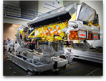
NOAA-N being built The NOAA-N Prime spacecraft is 13.75 feet long by 6.2 feet in diameter, and weighs 3,130 pounds at liftoff. Its solar array has 180.6 square feet of surface area and generates 833 watts at a zero degree sun angle. The instruments onboard NOAA-N Prime were provided by NASA and NOAA, and include the Advanced Very High Resolution Radiometer (AVHRR/3), the High Resolution Infrared Radiation Sounder (HIRS/4), the Advanced Microwave Sounding Unit A (AMSU-A), the EUMETSAT-supplied Microwave Humidity Sounder (MHS), the Solar Backscatter Ultraviolet Spectral Radiometer/2 (SBUV/2), the Space Environment Monitor/2 (SEM/2) and the Advanced Data Collection System (DCS/2). In addition, NOAA-N Prime carries two search and rescue instruments, the Search and Rescue Repeater (SARR) and the Search and Rescue Processor (SARP) that are used internationally for locating ships, aircraft, and people in distress. The use of satellites in search and rescue has been instrumental in saving more than 24,500 lives since the inception of the Search and Rescue Satellite-Aided Tracking (SARSAT) system.
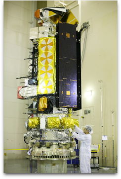
NOAA-N Prime being built 2 Spacecraft launch site processing at VAFB included end-to-end testing with the Satellite Operations Control Center in Suitland, Maryland, final spacecraft electrical testing and spacecraft inspections. The NOAA-N Prime spacecraft was launched from the Western Range Space Launch Complex-2 at Vandenberg Air Force Base, by a two-stage United Launch Alliance Delta II 7320-10C space launch vehicle. NASA‘s Goddard Space Flight Center, in Greenbelt, Maryland, is responsible for the procurement, development, launch services, and verification of the spacecraft, instruments, and unique ground equipment. Following spacecraft launch, Goddard is responsible for satellite health and safety during a comprehensive on-orbit verification period that lasts 45 days. Following satellite checkout, NASA turns operational control over to NOAA. NOAA will operate the satellite from the Satellite Operations Control Center along with the nation’s other environmental satellites.

The NOAA-N Prime satellite operates in a circular, near-polar orbit of 464 nautical miles above the Earth with an inclination angle of 98.73 degrees to the equator. Its orbital period — the time it takes to complete one orbit of the Earth — is approximately 102.14 minutes. The NOAA-N Prime orbit is Sun-synchronous, rotating eastward about the Earth’s polar axis 0.968 degrees each day, approximately the same rate and direction as the Earth’s average daily rotation about the sun. The rotation keeps the satellite in a constant position with reference to the sun for constant scene illumination throughout the year.

(Photos: NOAA-N Prime being built and tested, courtesy of Lockheed Martin)

Filed Under: Contracts & Commercial Deals, Launch Providers

Primary Sidebar

Coverage

  • Missions & Constellations
  • Business & Finance
  • Military & Defense
  • Launch
  • Software Automation & Ground Systems
  • Government & Regulation
  • Services & Applications

Most Read Stories

  • AST SpaceMobile Finalizes Assembly of Next-Generation BlueBirds for August SpaceX Launch
  • SpaceX Controlled-Deorbit Report Discloses Decommissioning of 260 Starlink Satellites Over Six Months
  • SpaceX Files FCC Application for 100,000 Third-Generation Starlink Satellites
  • EchoStar’s Dish DBS Initiates Prepackaged Chapter 11 Restructuring to Resolve Impending Senior Note Maturities
  • BNP Paribas Outlines Steep Regulatory Obstacles in SpaceX Mobile Integration Strategy

Secondary Sidebar

Footer


Satnews is a leading provider of satellite news, events, publications, research and other satellite industry information in both commercial and military enterprises worldwide.

Stories By Category

  • Business & Finance
  • Government & Regulation
  • Launch
  • Military & Defense
  • Missions & Constellations
  • Services & Applications
  • Software Automation & Ground Systems
  • Spectrum & Licensing
  • Startups & NewSpace Business

About Us

  • Leadership & Editorial Team
  • SatNews History
  • Free Satnews Subscription
  • SatNews Events
  • Magazines

Navigation

  • Latest Stories
  • Magazines
  • Events
  • Contact
  • Cookie & Privacy Policy for Satnews

We use cookies to ensure that we give you the best experience on our website. If you continue to use this site we will assume that you are happy with it.
x
Sign up Now (For Free)
Access daily or weekly satellite news updates covering all aspects of the commercial and military satellite industry.
Invalid email address
Notify Me Regarding ( At least one ):
We value your privacy and will not sell or share your email or other information with any other company. You may also unsubscribe at anytime.

Click Here to see our full privacy policy.
Thanks for subscribing!