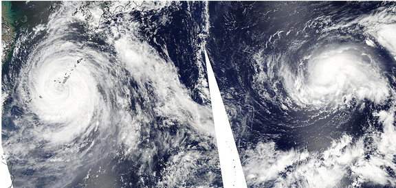
In one image, NASA's Aqua satellite captured two tropical cyclones in the western North Pacific on August 5th, Tropical Storm Merbok and the large Typhoon Muifa. NASA satellite imagery shows that Muifa is almost twice as big as Merbok. The Moderate Resolution Imaging Spectroradiometer (MODIS) instrument aboard NASA's Aqua satellite captured Typhoon Muifa near Okinawa, Japan, and Tropical Storm Merbok, farther east in the western Pacific at 4:35 UTC (12:35 a.m. EDT) on August 5, 2011. By having the storms side-by-side in one image, it is much easier to see how Merbok is a lot less organized than the more powerful Muifa. Muifa also has an eye, although cloud-filled, whereas Merbok does not.
On August 5, Typhoon Muifa's maximum sustained winds were near 80 knots, and typhoon-force winds extended out to 70 miles from the center. Tropical storm-force winds went much farther, out to 220 miles from the center, making Muifa a monster storm of about 440 miles in diameter. Muifa was only 45 nautical miles southwest of Kadena Air Force Base, Japan this morning (August 5) at 5 a.m. EDT, pounding the island with heavy rains, typhoon-force winds and very rough surf. Its center was near 25.8 North and 127.2 East and it was moving to the northwest near 7 knots (8 mph). By 8 a.m. EDT, Muifa's center had moved past Kadena and was located 55 nautical miles west-southwest of the island.

NASA's Aqua satellite captured Typhoon Muifa and Tropical Storm Merbok in the western Pacific at 4:35 UTC (12:35 a.m. EDT) on August 5, 2011. Muifa is almost twice as large as Merbok. Credit: NASA Goddard MODIS Rapid Response. Text credit: Rob Gutro,NASA Goddard Space Flight Center, Greenbelt, Md.
The maximum significant wave heights are reaching 36 feet creating extremely hazardous seas. Muifa is expected to recurve to the northwest or north and skirt the east coast of China and make landfall in Korea. Tropical storm Merbok is not a threat to land areas, and is moving around in the open waters of the North Pacific. It is located 675 miles west-northwest of Wake Island near 26.8N and 155.3E. Merbok's maximum sustained winds are near 50 knots, and tropical-storm force winds extend 120 miles from the center, making the storm 240 miles in diameter. Merbok is moving to the north-northwest at 8 knots and creating 21-foot high waves. Merbok is strengthening as it moves northwest and is expected to make typhoon strength before weakening and curving northeast.

