• Skip to primary navigation
  • Skip to main content
  • Skip to primary sidebar
  • Skip to secondary sidebar
  • Skip to footer
  • NEWS:
  • SatNews
  • SatMagazine
  • MilSatMagazine
  • SmallSat News
  • |     EVENTS:
  • SmallSat Symposium
  • Satellite Innovation
  • MilSat Symposium
  • SmallSat Europe

SatNews

Satellite Industry Intelligence Since 1983

Subscribe
  • LATEST
  • SatNews Events
  • Magazines
  • Calendar
  • Subscribe
  • Missions & Constellations
    • Exploration & Science Missions
    • In-Orbit Servicing & Orbital Operations
    • LEO Constellations
    • Mission Autonomy & Onboard Systems
    • Mission Deployments & Manifests
    • Navigation & PNT
    • SmallSat
    • Spacecraft & Payload Technology
    View All in Missions & Constellations →
    China Accelerates Orbital Internet Deployment with Successful Smart Dragon-3 Sea LaunchChina Accelerates Orbital Internet Deployment with Successful Smart Dragon-3 Sea Launch
    Smallsats Dominate 2025 Launch Landscape as Mass Efficiency PeaksSmallsats Dominate 2025 Launch Landscape as Mass Efficiency Peaks
    MIT STAR Lab Expands Scope from Lasercom Innovation to Space Policy ArchitectureMIT STAR Lab Expands Scope from Lasercom Innovation to Space Policy Architecture
    Northrop Grumman Contracted for Hungary’s HUGEO Sovereign Communications SatelliteNorthrop Grumman Contracted for Hungary’s HUGEO Sovereign Communications Satellite
  • Business
    • Contracts & Commercial Deals
    • Earnings & Financial Reporting
    • Events & Conferences
    • Funding & Venture Capital
    • Market Forecasts
    • Mergers & Acquisitions
    • Personnel Moves & Appointments
    View All in Business & Finance →
    SmallSat Europe Speaker Focus: Chiara Manfletti, NeuraspaceSmallSat Europe Speaker Focus: Chiara Manfletti, Neuraspace
    SmallSat Europe Speaker Focus: Daniel Bock, Morpheus SpaceSmallSat Europe Speaker Focus: Daniel Bock, Morpheus Space
    Lockheed Martin Outlines Strategic Space Technology Roadmap for 2026Lockheed Martin Outlines Strategic Space Technology Roadmap for 2026
    Industry Sentiment Shifts as Quilty Space Reveals Top 5 Takeaways from Satellite 2026Industry Sentiment Shifts as Quilty Space Reveals Top 5 Takeaways from Satellite 2026
  • Defense
    • Counterspace & ASAT
    • Defense Budgets & Procurement
    • ISR & Reconnaissance
    • MILSATCOM
    • Missile Warning & Defense
    • National Security Programs
    • Space Domain Awareness
    View All in Military & Defense →
    NRL to Showcase Sovereign Space Capabilities at 41st Space SymposiumNRL to Showcase Sovereign Space Capabilities at 41st Space Symposium
    Northrop Grumman Minotaur IV Lofted USSF Tech Demonstration Payloads to OrbitNorthrop Grumman Minotaur IV Lofted USSF Tech Demonstration Payloads to Orbit
    The End of the VSAT Parts BinThe End of the VSAT Parts Bin
    Procurement Lag vs. Conflict Speed: Can Defense Buying Cycles Keep Up with Space Innovation?Procurement Lag vs. Conflict Speed: Can Defense Buying Cycles Keep Up with Space Innovation?
  • Gov
    • Export Controls & Compliance
    • International Space Agreements
    • National Space Policy
    • Space Law & Treaties
    • Space Sustainability & Debris Policy
    • Space Traffic Management / Debris Removal
    View All in Government & Regulation →
    FCC Modernizes Satellite Spectrum Rules to Unleash Next-Generation BroadbandFCC Modernizes Satellite Spectrum Rules to Unleash Next-Generation Broadband
    SmallSat Europe Speaker Focus: Dr. Ane Aanesland, ThrustMeSmallSat Europe Speaker Focus: Dr. Ane Aanesland, ThrustMe
    Isaacman’s Budget Math: How NASA Plans to Reach the Moon With a Quarter Less MoneyIsaacman’s Budget Math: How NASA Plans to Reach the Moon With a Quarter Less Money
    FCC Seeks Comment on Expanding Spectrum Access for “Weird Space Stuff”FCC Seeks Comment on Expanding Spectrum Access for “Weird Space Stuff”
  • Launch
    • Launch Providers
    • Launch Schedule & Calendars
    • Launch Sites & Infrastructure
    • Rocket Technology & Vehicles
    View All in Launch →
    What the SpaceX IPO Changes for Every Satellite OperatorWhat the SpaceX IPO Changes for Every Satellite Operator
    €30 million Financing for PLD Space’s Small Satellite Launcher€30 million Financing for PLD Space’s Small Satellite Launcher
    Satellite Deployers to be Used on JAXA Small Satellite Mission by ExolaunchSatellite Deployers to be Used on JAXA Small Satellite Mission by Exolaunch
    CAS Space Successfully Launches Kinetica-2, Aiming for Global Cost LeadershipCAS Space Successfully Launches Kinetica-2, Aiming for Global Cost Leadership
  • Software
    • Autonomous Ground Operations
    • Data Processing & AI/ML
    • Digital Twins & Modeling
    • Ground Segment & Teleports
    • Mission Planning & Simulation
    • Space Systems Software Engineering
    • Spectrum & Licensing
    View All in Software Automation & Ground Systems →
    Keysight and Sateliot Win ESA and GSMA Foundry Challenge for 6G InnovationKeysight and Sateliot Win ESA and GSMA Foundry Challenge for 6G Innovation
    Automation and Agility: How SSC Space Go is Designed for the New Age of GroundAutomation and Agility: How SSC Space Go is Designed for the New Age of Ground
    Intellian Unveils Future Military and Aerospace Antenna Technologies at Satellite 2026Intellian Unveils Future Military and Aerospace Antenna Technologies at Satellite 2026
    The Downlink Deficit: The Pentagon’s Optical Mesh Network and the Terrestrial BottleneckThe Downlink Deficit: The Pentagon’s Optical Mesh Network and the Terrestrial Bottleneck
  • Services & Apps
    • Climate & Environmental Monitoring
    • Disaster Response & Security Mapping
    • Earth Observation & Imaging
    • Maritime & Aviation Satcom
    • Satellite Communications
    View All in Services & Applications →
    Kraken Robotics Integrates KATFISH Sonar on SEFINE RD-22 USV Following Multi-Naval DemonstrationsKraken Robotics Integrates KATFISH Sonar on SEFINE RD-22 USV Following Multi-Naval Demonstrations
    Astroscale Plans World-First Multi-Orbit Satellite Inspection MissionAstroscale Plans World-First Multi-Orbit Satellite Inspection Mission
    Cinemo Reimagines the Vehicle as a Software-Defined Entertainment HubCinemo Reimagines the Vehicle as a Software-Defined Entertainment Hub
    IEC Telecom Wins CSR Initiative of the Year at the Oil & Gas Middle East Awards 2026IEC Telecom Wins CSR Initiative of the Year at the Oil & Gas Middle East Awards 2026

DLR, Infoterra+ EADS Astrium… Firsts For TanDEM-X (EO)

June 28, 2010


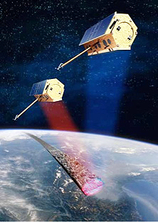
TanDEM-X, image courtesy of DLR
[SatNews] Germany’s new radar satellite, TanDEM-X, launched from Kazakhstan last Monday, has returned its first images of Earth. The spacecraft was created to image the most precise 3D map of the Earth’s surface.

The first images demonstrate the satellite is in good working order and is ready to team up with the TerraSAR-X satellite launched three years ago. The pair of satellites will trace the variation in height across the globe with precision of better than 6 feet. The satellite will support a number of applications, such as navigational devices for military jets to allow them to fly at very low altitudes. Infoterra GmbH, which has exclusive rights to commercialize the TanDEM information, says the market for radar products is steadily growing.

The new images show regions of Ukraine, northern Madagascar and Moscow. The pictures illustrate the unique ability of the equipment to use radar to sense the planet’s surface. The satellite is able to detect, for example, the choppiness of the waves in the Indian Ocean near Madagascar. TanDEM-X will be flying in a polar orbit that will take it in a similar path to that of TerraSAR-X, about 325 miles above the planet. The intention is to have the new satellite maintain an extremely close path to its sibling. At times, the two satellites will be as close as 650 feet to one another. The radar works by bouncing microwave pulses off the ground and sea surface. By timing how long it takes for the signal to return to the satellite, the instrument can determine differences in height. Three-dimensional image acquisition is expected to start in January.


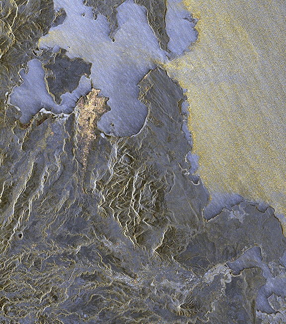
The ups and downs of the waves in the Indian Ocean (pale yellow) are charted by TanDEM-X as it flies over at a speed of seven kilometers per second. The change in the waves at the entrance to the Diego Suarez Bay is clearly visible. The water in the bay itself, on the shore of which the provincial capital, Antsiranana, can be recognized, is very flat — in contrast to the undulating ocean — and reflects the radar signals from TanDEM-X more uniformly. The area of valleys to the south drains the volcanic cone of Ambre-Bobaomby into the Indian Ocean. Credit: DLR.

The seamless digital elevation model (DEM) of the Earth’s surface will be built up over a period of three years. Ultimately, the satellites should be able to produce a vertical resolution of 3 to 6 feet and a spatial resolution of 40 feet, far superior to any global data recorded to date. The TerraSAR-X/TanDEM-X venture is operated on the basis of a public-private partnership. The Germany’s space agency (DLR) owns the hardware; satellite manufacturer EADS Astrium has developed and built the technology; and Infoterra GmbH processes and sells the data.

Filed Under: Earth Observation & Imaging

Primary Sidebar

Coverage

  • Missions & Constellations
  • Business & Finance
  • Military & Defense
  • Launch
  • Software Automation & Ground Systems
  • Government & Regulation
  • Services & Applications

Most Read Stories

  • L3Harris Unveils XL-300P: The First P25 Handheld with 5G and Satellite Direct-to-Device Connectivity
  • Rheinmetall Walked Away. Germany Should Take the Hint.
  • SpaceX Loses Contact With Starlink Satellite
  • Rocket Lab Emerging as Potential Bus Provider for 2,800-Satellite Equatys Constellation
  • SpaceX Accelerates Record-Breaking IPO Following Trillion-Dollar xAI Merger

Secondary Sidebar

Footer


Satnews is a leading provider of satellite news, events, publications, research and other satellite industry information in both commercial and military enterprises worldwide.

Stories By Category

  • Business & Finance
  • Government & Regulation
  • Launch
  • Military & Defense
  • Missions & Constellations
  • Services & Applications
  • Software Automation & Ground Systems
  • Spectrum & Licensing
  • Startups & NewSpace Business

About Us

  • Leadership & Editorial Team
  • SatNews History
  • Free Satnews Subscription
  • SatNews Events
  • Magazines

Navigation

  • Latest Stories
  • Magazines
  • Events
  • Contact
  • Cookie & Privacy Policy for Satnews

We use cookies to ensure that we give you the best experience on our website. If you continue to use this site we will assume that you are happy with it.
x
Sign up Now (For Free)
Access daily or weekly satellite news updates covering all aspects of the commercial and military satellite industry.
Invalid email address
Notify Me Regarding ( At least one ):
We value your privacy and will not sell or share your email or other information with any other company. You may also unsubscribe at anytime.

Click Here to see our full privacy policy.
Thanks for subscribing!