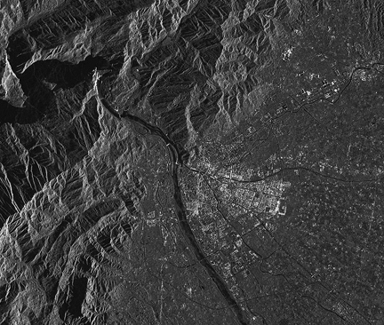
On May 13th, on the request of the Chinese government, the ASI satellites took the first two radar pictures of the region around the city of Guan Xian, one of the closest to the earthquake’s epicenter, showing, as it did with the disaster in Myanmar, its extraordinarily quick time response in the event of a crisis. Furthermore, owing to the particular weather conditions with heavy cloud cover and precipitation, only the radar of Italian satellites continued to operate. The images were processed at ASI’s COSMO-SkyMed Data Acquisition Centre in Matera, managed by Telespazio, whose staff worked late into the night to ensure the data could be provided in a timely manner. In the top left corner of the image, it is possible to spot out a dam—this will be constantly monitored over the next few days to avoid the risk that the city will be flooded by the water contained in the reservoir above.
COSMO-SkyMed will continue to supply new images of Sichuan to the Chinese government, Italy’s Civil Protection Department (which is organising an Italian aid mission in the region) as well as to various humanitarian organisations managing aid. The COSMO radar pictures are used to survey any damage to buildings and metallic structures, such as dams and bridges.