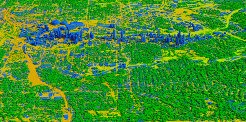
Vricon is launching their Telco Suite at this year’s Mobile World Congress (MWC) in Barcelona — MWC participants can see a demo of the Telco Suite in Vricon’s booth, located at #6L8.

Vricon 3D building and vegetation vectors in Atlanta, USA.
Image is courtesy of the company.
The Vricon Telco Suite is designed to help telecommunications companies navigate the rapid changes happening throughout the industry. With an increasing number of connected devices, high-definition content, and new services, the demands on networks are accelerating and growing exponentially. The Vricon Telco Suite is a cost-effective, next-generation solution that helps companies design networks for optimal performance, whether it’s to densify existing 4G LTE networks, prep for 5G to empower smart homes and the Internet of Things, or work a more complex HetNet.
Vricon’s Telco Suite provides a complete geodata solution that enables telco companies to analyze urban, suburban, and rural areas precisely and quickly. The Suite includes 3D and 4D vectors, clutter heights, clutter classes, orthoimagery, and terrain data. Based on high-resolution satellite imagery, Vricon’s geodata is highly detailed, of consistent quality and accuracy, and covers the world. At the heart of the Vricon Telco Suite is The Globe in 3D—a revolutionary new source of 3D geospatial and digital elevation data with 50cm resolution and 3m absolute accuracy. Defense and intelligence agencies are using The Globe in 3D today to support precision targeting, mission rehearsal, and GPS-denied navigation.

