
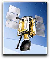
 Efforts to harness the energy potential of Earth’s ocean winds could soon gain an important new tool: global satellite maps from NASA. Scientists have been creating maps using nearly a decade of data from NASA‘s QuikSCAT satellite that reveal ocean areas where winds could produce wind energy. The new maps have many potential uses, including planning the location of offshore wind farms to convert wind energy into electric energy. The research, published this week in Geophysical Research Letters, was funded by NASA‘s Earth Science Division, which works to advance the frontiers of scientific discovery about Earth, its climate, and its future. QuikSCAT, launched in 1999, tracks the speed, direction and power of winds near the ocean surface. Data from QuikSCAT, collected continuously by a specialized microwave radar instrument named SeaWinds, also are used to predict storms and enhance the accuracy of weather forecasts.
NASA’s QuikSCAT + SeaWinds Could Help To Produce Wind Farms
Efforts to harness the energy potential of Earth’s ocean winds could soon gain an important new tool: global satellite maps from NASA. Scientists have been creating maps using nearly a decade of data from NASA‘s QuikSCAT satellite that reveal ocean areas where winds could produce wind energy. The new maps have many potential uses, including planning the location of offshore wind farms to convert wind energy into electric energy. The research, published this week in Geophysical Research Letters, was funded by NASA‘s Earth Science Division, which works to advance the frontiers of scientific discovery about Earth, its climate, and its future. QuikSCAT, launched in 1999, tracks the speed, direction and power of winds near the ocean surface. Data from QuikSCAT, collected continuously by a specialized microwave radar instrument named SeaWinds, also are used to predict storms and enhance the accuracy of weather forecasts.