• Skip to primary navigation
  • Skip to main content
  • Skip to primary sidebar
  • Skip to secondary sidebar
  • Skip to footer
  • NEWS:
  • SatNews
  • SatMagazine
  • MilSatMagazine
  • SmallSat News
  • |     EVENTS:
  • SmallSat Symposium
  • Satellite Innovation
  • MilSat Symposium
  • SmallSat Europe

SatNews

Satellite Industry Intelligence Since 1983

Subscribe
  • LATEST
  • SatNews Events
  • Magazines
  • Calendar
  • Subscribe
  • Missions & Constellations
    • Exploration & Science Missions
    • In-Orbit Servicing & Orbital Operations
    • LEO Constellations
    • Mission Autonomy & Onboard Systems
    • Mission Deployments & Manifests
    • Navigation & PNT
    • SmallSat
    • Spacecraft & Payload Technology
    View All in Missions & Constellations →
    SpaceX’s Secret ‘Starfall’ Capsule Wins FAA Approval for Pacific Reentry TestsSpaceX’s Secret ‘Starfall’ Capsule Wins FAA Approval for Pacific Reentry Tests
    NOAA Activates First Dedicated U.S. Space Weather Satellite One Million Miles from EarthNOAA Activates First Dedicated U.S. Space Weather Satellite One Million Miles from Earth
    Thales Alenia Space to coordinate EROSS SC On-Orbit Servicing projectThales Alenia Space to coordinate EROSS SC On-Orbit Servicing project
    Astroscale Launches Industry Initiative to Study Atmospheric Impact of Spacecraft ReentryAstroscale Launches Industry Initiative to Study Atmospheric Impact of Spacecraft Reentry
  • Business
    • Contracts & Commercial Deals
    • Earnings & Financial Reporting
    • Events & Conferences
    • Funding & Venture Capital
    • Market Forecasts
    • Mergers & Acquisitions
    • Personnel Moves & Appointments
    View All in Business & Finance →
    SOMA Satellite Factory: Planet Labs Expands San Francisco HQ to Supercharge Production PipelineSOMA Satellite Factory: Planet Labs Expands San Francisco HQ to Supercharge Production Pipeline
    Riding the Starship: The SpaceX IPO Is Set to Rocket Seattle’s Aerospace EcosystemRiding the Starship: The SpaceX IPO Is Set to Rocket Seattle’s Aerospace Ecosystem
    Space Race Moves to Wall Street: China’s Private Rocket Makers Target IPOs as Historic SpaceX Flotation NearsSpace Race Moves to Wall Street: China’s Private Rocket Makers Target IPOs as Historic SpaceX Flotation Nears
    Behind the Screens: The Massive Video Over-IP Infrastructure Powering the World CupBehind the Screens: The Massive Video Over-IP Infrastructure Powering the World Cup
  • Defense
    • Counterspace & ASAT
    • Defense Budgets & Procurement
    • ISR & Reconnaissance
    • MILSATCOM
    • Missile Warning & Defense
    • National Security Programs
    • Space Domain Awareness
    View All in Military & Defense →
    Space-Based Shield: Spire Global and Diehl Defence Partner to Build European Missile Warning NetworkSpace-Based Shield: Spire Global and Diehl Defence Partner to Build European Missile Warning Network
    Qorvo Unveils Compact X-Band Radar Module to Enhance Defense System PerformanceQorvo Unveils Compact X-Band Radar Module to Enhance Defense System Performance
    Energration and Atombeam Partner on DARPA Proposal to Revolutionize Tactical Data Movement at the Defense EdgeEnergration and Atombeam Partner on DARPA Proposal to Revolutionize Tactical Data Movement at the Defense Edge
    American military space closed around one company in seven daysAmerican military space closed around one company in seven days
  • Gov
    • Export Controls & Compliance
    • International Space Agreements
    • National Space Policy
    • Space Law & Treaties
    • Space Sustainability & Debris Policy
    • Space Traffic Management / Debris Removal
    View All in Government & Regulation →
    Major opportunities for 2 GHz over EuropeMajor opportunities for 2 GHz over Europe
    “Dual-use” is the funding word. It’s also the label operators want off.“Dual-use” is the funding word. It’s also the label operators want off.
    Sovereignty got an answer on Day 3. Two answers, actually, and a commercial veto.Sovereignty got an answer on Day 3. Two answers, actually, and a commercial veto.
    Dependency killed the old debate. Sovereignty is the new one, and Europe hasn’t agreed what it means.Dependency killed the old debate. Sovereignty is the new one, and Europe hasn’t agreed what it means.
  • Launch
    • Launch Providers
    • Launch Schedule & Calendars
    • Launch Sites & Infrastructure
    • Rocket Technology & Vehicles
    View All in Launch →
    Breaking the TRL Bottleneck: Space Phoenix Systems Debuts Cost-Effective Space Test-and-Return ServiceBreaking the TRL Bottleneck: Space Phoenix Systems Debuts Cost-Effective Space Test-and-Return Service
    Twelve Scientific Payloads Experience Microgravity Aboard SubOrbital Express-5Twelve Scientific Payloads Experience Microgravity Aboard SubOrbital Express-5
    Amazon Leo Constellation Surpasses 330 Satellites Following Latest Atlas V LaunchAmazon Leo Constellation Surpasses 330 Satellites Following Latest Atlas V Launch
    If You Thought Space Was Hard Try to Get Your Satellite On a RocketIf You Thought Space Was Hard Try to Get Your Satellite On a Rocket
  • Software
    • Autonomous Ground Operations
    • Data Processing & AI/ML
    • Digital Twins & Modeling
    • Ground Segment & Teleports
    • Mission Planning & Simulation
    • Space Systems Software Engineering
    • Spectrum & Licensing
    View All in Software Automation & Ground Systems →
    Software Over the Air: FatPipe Launches Acceleration Tool to Unclog Starlink and Amazon LEO LinksSoftware Over the Air: FatPipe Launches Acceleration Tool to Unclog Starlink and Amazon LEO Links
    Three LEO Operators Bet 2026 on a Supply Chain Built for 2027Three LEO Operators Bet 2026 on a Supply Chain Built for 2027
    NASA Advances Interoperable Space Networks with Successful PExT DemonstrationNASA Advances Interoperable Space Networks with Successful PExT Demonstration
    KSAT and iQPS Expand Strategic Alliance to Accelerate High-Frequency SAR ConstellationKSAT and iQPS Expand Strategic Alliance to Accelerate High-Frequency SAR Constellation
  • Services & Apps
    • Climate & Environmental Monitoring
    • Disaster Response & Security Mapping
    • Earth Observation & Imaging
    • Maritime & Aviation Satcom
    • Satellite Communications
    View All in Services & Applications →
    Eutelsat and Tototheo Global Forge Partnership to Deliver LEO Connectivity Across Maritime and Government SectorsEutelsat and Tototheo Global Forge Partnership to Deliver LEO Connectivity Across Maritime and Government Sectors
    Marlink Equips Groupama-FDJ Cycling Team with Hybrid Starlink and LTE NetworkMarlink Equips Groupama-FDJ Cycling Team with Hybrid Starlink and LTE Network
    Viasat Secures Lockheed Martin Contract for NOAA’s Next-Generation AircraftViasat Secures Lockheed Martin Contract for NOAA’s Next-Generation Aircraft
    SES Partners with Viva to Launch Multi-Orbit In-Flight ConnectivitySES Partners with Viva to Launch Multi-Orbit In-Flight Connectivity

An Eye On Hurricane Ida’s Impact Through Satellite Data

September 12, 2021

The destruction caused by Hurricane Ida was notable for its severity and breadth, stretching from the Gulf Coast to the US Northeast, leaving a devastating toll in its wake.

Hurricane Ida (NOAA)

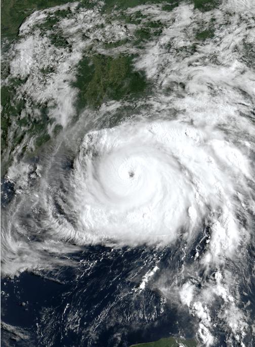
How can you even begin to monitor such a storm, particularly as it unfolds? Obtaining information from the ground isn’t necessarily practical. It’s simply too dangerous to be outside, and there’s too much area to cover.

A better solution leverages satellite imagery, specifically synthetic aperture radar (SAR), a satellite-borne sensor that works in any weather conditions, day or night.

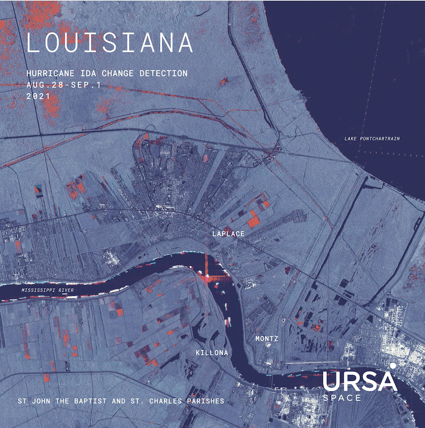
Our analysis below is based on SAR imagery, collected over parts of Louisiana where Hurricane ida struck a hard blow, allowing the viewer to see specific places in which flooding and damage occurred.

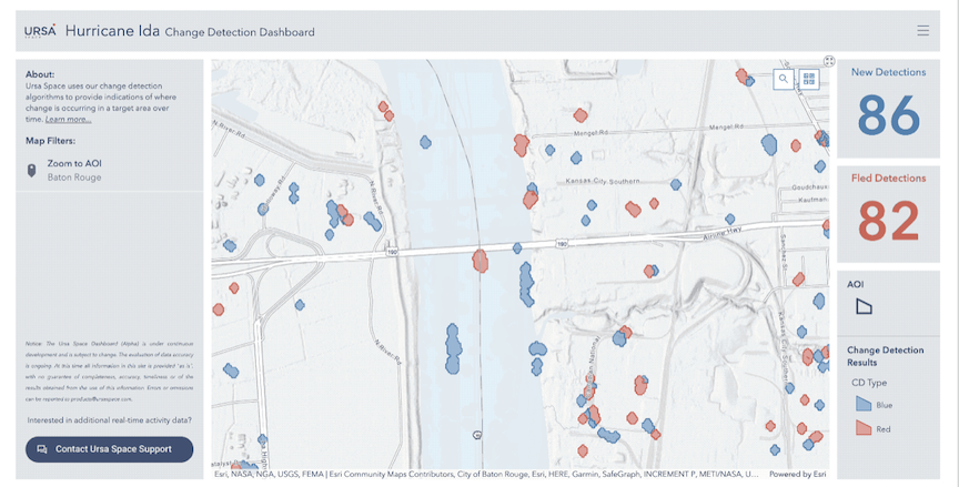
We created a dashboard, which you can access here, to explore our results, as of August 29, 2021, the same day that Hurricane Ida made landfall as a Category 4 storm.

The video below is a preview of the dashboard. You can select an area of interest (AOI) from the dropdown menu to move the map to that location. The indicators on the right show the counts of detections within the current map view.

This still shot is taken from a video’s preview of the dashboard.

The impact of Hurricane Ida was also felt offshore, as tanker traffic was seriously disrupted in response to the storm.

The image above provides a closer look at some of the hard-hit areas along the banks of the Mississippi River, approximately 30 miles northwest of New Orleans. St. John the Baptist, seen above, is bordered by three lakes: Lake Pontchartrain, Lake Maurepas, and Lac des Allemands.

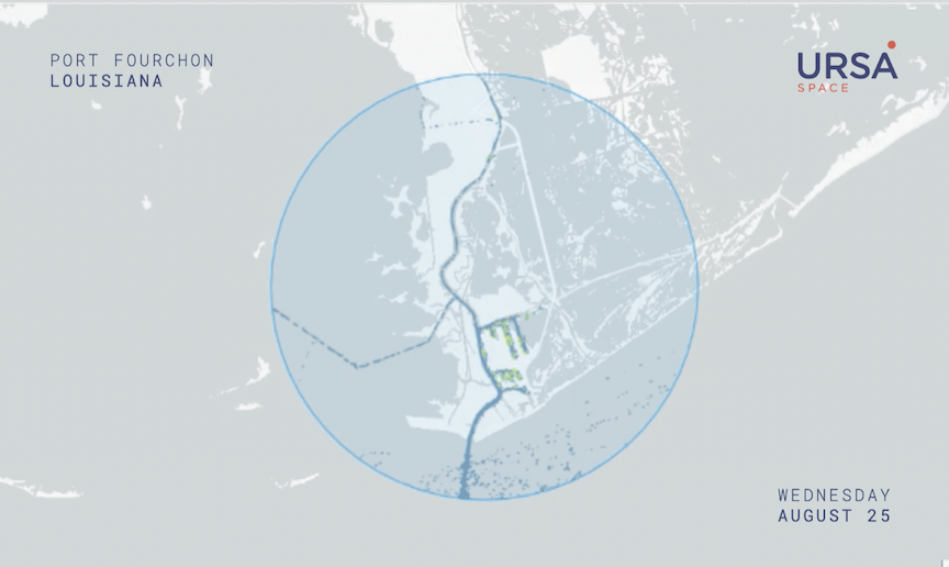
The US Gulf Coast is home to large facilities where oil, gas & petrochemicals are produced, stored and transported. Most ports along the Gulf Coast saw a decline in activity, including Port Fourchon, the land base of the Louisiana Offshore Oil Port (LOOP).

LOOP is one of the largest privately-owned oil terminals in the United States. It is the only port that can handle fully-laden supertankers, and now facilitates exports of crude oil after years of domestic production growth.

Lac des Allemands, which sits only 5 miles southwest of the town of Killona, was inundated with water, visible above in the areas colored red.

As of September 2, LOOP was conducting repairs sustained during the storm, and had suspended deliveries beforehand.

When will LOOP return to normal? Ursa Space measures crude oil inventories at more than 900 locations, including LOOP, which provide valuable information in times like this. Contact us for more information.

In addition, Ursa analyzed Automatic Identification System (AIS) data, provided by Spire. AIS refers to a type of transponder revealing a ship’s location and other identifying characteristics.

Our initial analysis showed a steep decline in ships at Port Fourchon when the hurricane made landfall on August 29.

While this trend wasn’t limited to Port Fourchon, as other ports in the path of the storm shut as a result, the AIS data shows where some ships might have gone instead.

The Port of Galveston, located approximately 280 miles west of Port Fourchon as the crow flies, actually saw an uptick in ship activity.

This example, showing the ability to monitor a storm, is part of an ongoing effort by Ursa Space to help emergency services, utilities and insurance companies, among others, respond faster and more efficiently to severe weather.

Other examples of our work include Hurricane Irma in Florida, Hurricane Dorian in the Bahamas and dam collapses in Inner Mongolia.

By Geoffrey Craig, Author

Filed Under: Data Processing & AI/ML, Earth Observation & Imaging

Primary Sidebar

Coverage

  • Missions & Constellations
  • Business & Finance
  • Military & Defense
  • Launch
  • Software Automation & Ground Systems
  • Government & Regulation
  • Services & Applications

Most Read Stories

  • SpaceX Debuts Starship V3: Redefining Heavy-Lift Launch Capability
  • SpaceX Is Worth $1.75 Trillion. Only 7% of That Is Real.
  • FCC Approves Landmark Spectrum Sharing and Direct-to-Device Frameworks
  • SpaceX: 10,000 Launches Annually
  • The end of GEO?

Secondary Sidebar

Footer


Satnews is a leading provider of satellite news, events, publications, research and other satellite industry information in both commercial and military enterprises worldwide.

Stories By Category

  • Business & Finance
  • Government & Regulation
  • Launch
  • Military & Defense
  • Missions & Constellations
  • Services & Applications
  • Software Automation & Ground Systems
  • Spectrum & Licensing
  • Startups & NewSpace Business

About Us

  • Leadership & Editorial Team
  • SatNews History
  • Free Satnews Subscription
  • SatNews Events
  • Magazines

Navigation

  • Latest Stories
  • Magazines
  • Events
  • Contact
  • Cookie & Privacy Policy for Satnews

We use cookies to ensure that we give you the best experience on our website. If you continue to use this site we will assume that you are happy with it.
x
Sign up Now (For Free)
Access daily or weekly satellite news updates covering all aspects of the commercial and military satellite industry.
Invalid email address
Notify Me Regarding ( At least one ):
We value your privacy and will not sell or share your email or other information with any other company. You may also unsubscribe at anytime.

Click Here to see our full privacy policy.
Thanks for subscribing!