
On February 5, 2026, Vantor (formerly Maxar Intelligence) was awarded a $5.3 million contract by the National Geospatial-Intelligence Agency (NGA) under the Luno B program.
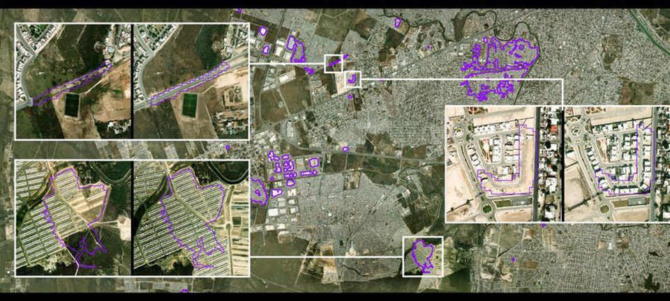
The initiative focuses on the automated detection of real-time changes to the Earth’s landscape, leveraging artificial intelligence to process vast datasets from multiple space-based sensors. By integrating data from its own high-resolution imaging satellites with third-party electro-optical and Synthetic Aperture Radar (SAR) constellations, Vantor will provide the intelligence community with high-fidelity insights into shifts in buildings, roads, vegetation, and ground disturbances.
The Luno B Program: Transitioning from Images to Answers
The contract is part of the NGA’s Luno program, an agile acquisition strategy designed to harness the innovation of the commercial geospatial industry for national security. While the earlier Luno A phase focused on object detection—such as tracking aircraft and ships—the Luno B project emphasizes broader Land Use Land Cover (LULC) characterization. Vantor’s proprietary AI models are designed to achieve precise, pixel-level alignment across diverse sensor types, ensuring that even minor physical changes are accurately identified amidst varying viewing angles and resolutions.
Operational Impact: From Conflict Zones to Disaster Relief
These automated insights are intended to support a wide range of critical missions, including monitoring regional conflicts, assessing the impact of natural and man-made disasters, and coordinating humanitarian assistance. By using AI to scale global monitoring, Vantor enables the NGA to maintain an up-to-date “digital twin” or “living globe,” reducing the manual burden on analysts and providing policymakers with a decisive advantage in rapidly changing environments.
“To do continuous change detection across the entire world’s terrain at scale, that’s when you really need to be able to use AI,” stated Susanne Hake, Executive Vice President and General Manager of U.S. Government at Vantor. The contract solidifies Vantor’s role in providing the foundational geospatial intelligence that powers approximately 90% of the U.S. government’s current spatial awareness.
| Contract Feature | Details |
| Contract Value | $5.3 Million |
| Issuing Agency | National Geospatial-Intelligence Agency (NGA) |
| Program | Luno B (Commercial Data & Analytics) |
| Core Technology | AI-Powered Automated Change Detection |
| Sensor Types | High-Res Electro-Optical (EO) & Synthetic Aperture Radar (SAR) |
| Primary Goal | Real-time tracking of terrain, infrastructure, and land cover changes |