• Skip to primary navigation
  • Skip to main content
  • Skip to primary sidebar
  • Skip to secondary sidebar
  • NEWS:
  • SatNews
  • SatMagazine
  • MilSatMagazine
  • SmallSat News
  • |     EVENTS:
  • SmallSat Symposium
  • Satellite Innovation
  • MilSat Symposium
  • SmallSat Europe

SatNews

  • LATEST
  • EXPLORE ⌄
    • Missions & Constellations
    • Business & Finance
    • Military & Defense
    • Launch
    • Software Automation & Ground Systems
    • Government & Regulation
    • Services & Applications
  • Magazines
  • Events
  • Jobs
  • Calendar ⌄
    • IN PERSON
    • VIRTUAL
  • Subscribe

Two Unseenlabs satellites launched + deployed via the SpaceX Transporter-9 mission

November 12, 2023

Unseenlabs has successfully launched two new satellites, BRO-10 and BRO-11, as part of SpaceX’s Transporter-9 mission via Exolaunch.

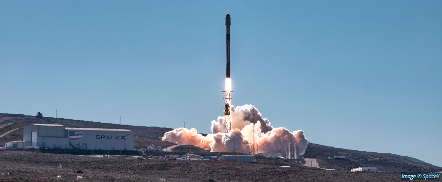
The satellites lifted off aboard SpaceX’s Falcon 9 launch vehicle from Vandenberg Space Force Base in California on November 11. This achievement represents a significant step forward in Unseenlabs’ ongoing mission to enhance maritime surveillance through its unique technology, capable of detecting the presence of any ship, whether cooperating or not, regardless ofits geographical location.

With BRO-10 and BRO-11 now on-orbit at an altitude of 520 kilometers, Unseenlabs’ satellite constellation expands, greatly amplifying the company’s capacity to provide RF data and solutions. Unseenlabs’ constellation is now comprised of 11 satellites, resulting in 11 simultaneous RF data collection points, thanks to the company’s smallsat technology.

The success of this launch propels Unseenlabs even further in the firm’s mission to offer comprehensive vessel characterization and precise geolocation, meeting the increasing demands of maritime surveillance across the globe.The new capabilities introduced by these satellites underscore Unseenlabs’ commitment to safeguarding marine assets and environments from threats and unlawful activities.

The expansion of the constellation offers an extended operational reach and increased surveillance and caters to the needs of government entities, NGOs, and private sector stakeholders such as insurers, worldwide. This advancement significantly contributes to improving the global maritime landscape, particularly at a time when maritime activities continue to thrive.

Filed Under: Disaster Response & Security Mapping, LEO Constellations

Primary Sidebar

Coverage

  • Missions & Constellations
  • Business & Finance
  • Military & Defense
  • Launch
  • Software Automation & Ground Systems
  • Government & Regulation
  • Services & Applications

Most Read Stories

  • Global Shift Toward Sovereign Launch Gains Momentum Amid Geopolitical Tensions
  • SES Executive Confirms End of the 15-Year Satellite Era
  • SpaceX Unveils ‘Stargaze’ System to Revolutionize Space Traffic Management
  • The Space Data Layer is Coming, Just Not as Fast or as Small as You Think
  • Space Has a Plumbing Problem, and It’s Getting Expensive

About Satnews

  • Contacts
  • History

Archives

Secondary Sidebar

We use cookies to ensure that we give you the best experience on our website. If you continue to use this site we will assume that you are happy with it.
x
Sign up Now (For Free)
Access daily or weekly satellite news updates covering all aspects of the commercial and military satellite industry.
Invalid email address
Notify Me Regarding ( At least one ):
We value your privacy and will not sell or share your email or other information with any other company. You may also unsubscribe at anytime.

Click Here to see our full privacy policy.
Thanks for subscribing!