
The ever unfolding revolution in marine and ocean information and communications technology (ICT), and satellite and data solutions will be presented at Oceanology International 2018, March 13-15, in London which will reflect the importance of evolving topics that include:
- underwater Internet of Things
- command and control of marine platforms
- applications of AIS and satellite-derived data sources
- access to ocean data
This event is specific to marine science and ocean technology the 2018 London event will host some of the world’s leading Ocean ICT products, services and solutions as exhibitors, specialists, experts and conference speakers converge to discuss and share the latest developments.
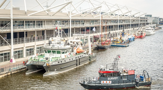
Vessels and Demonstrations
The dockside position of ExCeL London gives exhibitors an excellent opportunity to demonstrate their equipment in action to the global marine science community. Visitors are able to watch live coverage of equipment at work via the popular elevated viewing platforms on the dockside or via a covered private meeting area as well as network.
As chair of the Ocean ICT conference track, former UK National Hydrographer and master mariner Rear Admiral Nick Lambert believes recent game-changing developments have exciting implications for hydrography and bathymetry, and, ultimately, the future management of global oceans to benefit the environment and humanity.
Lambert said that this is an exciting time. They are on the cusp of ‘sea vision’, an epoch when they will know everything they need about human activity and maritime operations of all kinds in complex sea basins. AIS, and now satellite AIS, along with satellite derived data sources such as optical imagery and synthetic aperture radar are exponentially improving in performance, offering corroborating information about maritime operations from space. Fusing these space derived sources with terrestrial coastal radar pictures and historical datasets such as vessel registers will provide a comprehensive, reliable picture of human activities on our seas and oceans.
Lambert also highlights the important role of hydrographers within this revolution and the need for geographical representations in the form of maps, charts or GIS solutions to enable decision making, and the importance of data about the bathymetry of marine environments so that resources can be exploited in a sustainable, but economically viable, manner.
At Oi18, Lambert will oversee a comprehensive range of conference sessions alongside fellow chairs:
- Dr Clare Postlethwaite, Coordinator of the Marine Environmental Data and Information Network (MEDIN)
- Dr Helen Wells, Business Group Leader of Meteorology and Science at the Met Office
Sessions will encompass Ocean ICT Enabling Enhanced Marine Sensing Command and Control, Widening Access to Ocean Data and Novel Systems using Ocean Data.
Dr Wells commented that at the Met Office, they are really interested in taking the opportunities afforded to them by new technologies to widen access to ocean data and deliver innovation that leads to improvements in safety and efficiency and ultimately the growth of the blue economy. To widen access to ocean data, they are trying to encourage the discussion of data standards and connectivity, such as how the data can be transmitted in real-time or in slower time. We are also highlighting some novel uses of ocean data in the hope of stimulating more innovation and thus delivering more value from the data.
As coordinator of MEDIN, a partnership committed to sharing UK marine data, Dr Postlethwaite is at the forefront of promoting access to data by collaborating with representatives from government departments, research institutions and private companies with the aim of achieving wide commercial, scientific, policy and conservation benefits.
She said that the technology involved with acquiring, transmitting and publishing marine data is changing rapidly as the community responds to a desire for receiving data in real-time, new types of sensors measuring new ocean parameters, as well as an ever-increasing volume of data from existing sensors. She is excited to hear about some of these developments when she co-chairs the Ocean ICT technical track session at Oceanology International 2018.
Addressing demand from visitors and exhibitors, organizer Reed Exhibitions expanded Oi18 with the launch of the Ocean ICT Expo, a brand new exhibition focus on the IT, communications and data solutions that form the technical foundation for modern oceanspace research and industry.
Leading exhibitors within the Ocean ICT focus will include:
- dotOcean
- Metocean Telematics
- Liquid Robotics
- Sonardyne
- Oceanwise
- AgileTek
- Emodnet
- The British Oceanographic Data Centre (BODC)
- Esri
- Plocan
- Deco Geophysical Software
- EOMAP GmbH & Co. KG.
Mapping and spatial data analytics technology specialist Esri is focused on Marine Data Cyber Infrastructure (Big Data) requirements, and building-out the Web GIS applications to deliver rapidly-configured and real-time Information Products. The company anticipates powerful monitoring and modeling will result soon in benefits.
Esri says its work will impact the following areas:
- Port Authority harbor masters and reinsurers
- making navigation decisions less risky
- seafood suppliers and shippers
- ensuring safety of the food supply
- environmental domain monitors and developers
- building better coastal installations with shorter permit times
- hydrologic forecast offices and scientific research institutions performing insightful science in the complex estuaries of the world
Meanwhile, EOMAP, global provider of satellite-derived information in maritime and inland waters for the offshore industry and government agencies and a pioneer in the field of satellite-derived bathymetry, seafloor mapping and high resolution water quality monitoring, is exhibiting at Oi18 as well as presenting in the ‘Satellite Toolkit: Rapid access to coastal spatial datalayers’ session in the Ocean ICT conference track.
The 24th edition of the Oceanology International biennial global forum will bring together 100’s of highly targeted IT and data professionals looking to procure specialist solutions, alongside the traditional OI audience of more than 7,500 people. The event will also spotlight technological developments including robotics, advanced sensor technology and autonomous systems. The conference program will boast 11 free-to-attend technical tracks. Oceanology International 2018's information and registration here.