
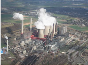
MicroCarb is designed to map sources and sinks of carbon dioxide (CO2)—the most important greenhouse gas—on a global scale. The mission is currently in the development phase, with launch of a microsatellite planned for 2020.
This agency has been awarded the responsibility of measuring CO2 levels exclusively using a spectrometer scanning at visible and near infra-red wavelengths.
CNES, the French Space Agency, has awarded a contract to design and build the optical instrument for MicroCarb, a micro-satellite to map global carbon dioxide levels. After launch in 2020, the satellite will study carbon dioxide sources (which produce CO2) and sinks (which absorb it) to understand how this greenhouse gas is affecting climate change.
“When it comes to understanding what is happening to our climate here on Earth, we need the latest technology to give us reliable and accurate data,” said François Auque, Head of Space Systems. “This is where MicroCarb comes in, a next-generation instrument which will help us to finally understand what CO2 is doing to our environment and our climate.”
MicroCarb will be the first European mission dedicated solely to measuring CO2 levels using a spectrometer scanning at visible and near infra-red wavelengths. The instrument is so accurate it can measure CO2 levels accurately to within one part in a million. This mission complements Merlin, which measures methane levels by LIDAR, an instrument that measures distance by illuminating a target with a laser light, which Airbus Defence and Space is also designing and building for CNES and the German Aerospace Centre DLR.
MicroCarb is a priority to understand and monitor climate change. The program launch was announced at COP21 in Paris in December 2015. Airbus Defence and Space will lead the manufacture of the optical instrument at its Toulouse site, with a large contribution from French SMEs.