

A new release of Airbus' WorldDEM4Ortho, a part of their WorldDEM portfolio, provides an accurate elevation model for global orthorectification of high and very high resolution optical and radar satellite data.
Airbus Defence and Space's WorldDEM4Ortho enables corrections of all distortions induced by the topographical variations of the Earth’s surface and satellite orientation when acquiring an image. Covering the Earth’s land surface, WorldDEM4Ortho is a consistent and accurate elevation model for orthorectification on a global scale.
Without these geometrical corrections, satellite images cannot be used in Geographical Information Systems or for any mapping related applications. With the huge development of new geolocated applications like business analytics, location-based services or tourism, the needs for such a consistent and precise elevation model are are greatly increasing.
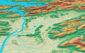
WorldDEM4Ortho is based on the global WorldDEM dataset and is produced via a fully automated process featuring a vertical accuracy of four meters in a 24 meter raster. Identified disturbing terrain artefacts are removed. Bodies of water such as lakes or sea are flattened. Rivers are stepped with a flow that follows the surrounding shorelines. Adaptive smoothing processes are also applied to different landscapes and land-use such as urban areas to avoid distortions in the orthorectified image.