

[SatNews] The first of five instruments that will fly on JPSS-1, NOAA’s next polar orbiting environmental satellite, successfully completed pre-shipment review last week—the Clouds and the Earth’s Radiant Energy System (CERES) will be on board the JPSS-1 satellite mission, which is scheduled to launch in early 2017.
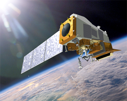
An artistic rendition of the JPSS-1, NOAA’s next polar orbiting environmental satellite.
Image credit, Ball Aerospace & Technologies Corp.
CERES measures reflected sunlight and thermal radiation emitted by the Earth and builds on the highly successful legacy instruments flown on NOAA’s previous Polar-orbiting Operational Environmental Satellites (POES) and NASA’s Earth Observing System (EOS) missions.
“CERES is the first JPSS-1 instrument to reach this important milestone, and the others are not far behind,” said Mary Kicza, assistant administrator for NOAA’s Satellite and Information Service. “We’re on track to have JPSS-1 ready to launch in 2017, adding to a robust satellite fleet that provides vital environmental intelligence for the nation and the world.”
Long-term satellite data from CERES will help scientists and researchers understand the links between the Earth’s energy balance, both incoming and outgoing, and parts of the atmosphere that affect it. Data from CERES will also improve observations of seasonal climate forecasts, including large-scale events like El Niño and La Niña. The CERES instrument is built by Northrop Grumman Aerospace Systems in Redondo Beach, California., and will be shipped to Ball Aerospace & Technologies Corp. in Boulder, Colorado, to be installed onto the JPSS-1 spacecraft.
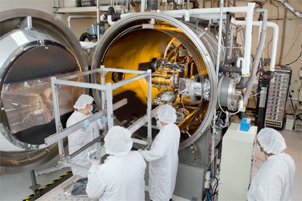
CERES instrument during testing at Northrop Grumman’s manufacturing facility in Redondo Beach, California.
Photo is courtesy of Northrop Grumman Corporation.
JPSS is a collaboration between NOAA and NASA, and ensures continuous critical, global Earth observations including atmosphere, clouds, oceans, snow, ice, ozone and vegetation. NOAA’s National Weather Service uses JPSS data as a critical input for numerical forecast models, providing the basis for mid-range forecasts three to seven days ahead of a severe weather event. JPSS data also contribute to operational forecasting in polar regions including Alaska and support long-term forecasting. JPSS also enables scientists and forecasters to monitor and predict weather patterns with greater accuracy and to study long-term climate trends by extending the more than 30-year satellite data record.
Four instruments for JPSS-1 are yet to be delivered:
- The Advanced Technology Microwave Sounder (ATMS) and Cross-track Infrared Sounder (CrIS) work closely together to provide atmospheric and temperature profiles for weather forecasting
- The Visible Infrared Imaging Radiometer Suite (VIIRS), which creates high-resolution imagery of the atmosphere using visible and infrared channels
- OMPS, or the Ozone Mapping and Profiler Suite, which measures ozone concentration in the atmosphere and provides significant input to the numerical forecast models
NOAA’s mission is to understand and predict changes in the Earth's environment, from the depths of the ocean to the surface of the sun, and to conserve and manage our coastal and marine resources. To learn more about JPSS, view exciting satellite imagery, and experience the science behind the satellites, please visit http://www.jpss.noaa.gov/.