
Spottitt Ltd. has launched a cloud-based workspace that puts massive satellite imagery sources and advanced analysis capabilities readily available for energy, environment, and infrastructure professionals that is available now through Veracity, DNV GL’s industry data platform an online marketplace.
Spottitt CEO Lucy Kennedy said that Spottitt provides users with everything they need to extract valuable information from satellite imagery and related data sets in a secure, self-service cloud workspace. With Spottitt, clients do not need powerful computers, image processing software or formal GIS training to leverage the value of geospatial data.

Effective immediately, users may set up a Spottitt account through the Veracity digital marketplace. DNV GL, a global quality assurance and risk management company based in Norway, established the Veracity ecosystem to provide easy access to databases, analytics, and applications for its worldwide customer base in energy, maritime and other industries.
The Spottitt online portal gives users instant access to multiple satellite image sources, including open source data from the U.S. Landsat and European Sentinel-2 satellites and sub-meter commercial image products from Airbus Defence & Space and DigitalGlobe. Other geospatial products include Digital Elevation Models (DEMs) and infrastructure feature layers.
Kennedy added that a Spottitt user simply defines their geographic area of interest, and the system provides thumbnail images of available data sets for purchase. The experience is fast, simple and efficient thanks to cloud-based processing and storage.
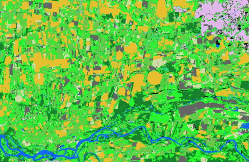
Spottitt automated Land Cover Analysis generated from 10m resolution Sentinel 2 imagery of Chile, differentiating Agricultural, Urban, Grassland and other land cover types
The major differentiator of Spottitt is the data analytics it offers in the cloud. The user selects from a variety of enhancement and information extraction algorithms that can be applied to their chosen data set.
Designed primarily for use in energy, environmental monitoring, and infrastructure development applications, these analytics functions include the following:
- Land Cover Classification
- Building Recognition Analysis (Footprint extraction)
- Normalized Difference Vegetation Index
- Normalized Difference Water Index
- Rule-based Greenfield Selection
- Rule-based Wind Turbine Site Selection
Kennedy said that analytics results are delivered to the client workspace for viewing, editing, and further manipulation within Spottitt. They can be shared with other users or downloaded in GIS-ready formats into other mapping software environments.
The Spottitt solution has already been used extensively in the renewable energy and infrastructure management fields. Energy firms have used it to select the optimal locations for wind turbines by mapping land cover and terrain characteristics in areas of interest. The Spottitt building recognition and change detection analytics are ideal for energy utilities to monitor changes and risks in infrastructure assets over time.
Spottitt workspaces are securely hosted in the Microsoft Azure cloud, giving clients access from any browser-equipped device at any time. Clients are offered the option of paying for imagery and processing as they go or under subscription arrangements.
Barry Authers, Commercial manager Veracity by DNV GL concluded that they are delighted to welcome Spottitt to Veracity and their rapidly growing ecosystem of applications, services and data. They see big potential in combining satellite data with existing asset data and the Spottitt Energy solution is a valuable contribution to their marketplace.