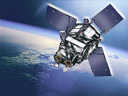
Artistic rendition of the Ingenio satellite, courtesy of Astrium
...requirements for the system that will manage the Spanish satellite Ingenio. The technological company leads the development, implementation and start-up of the ground segment for the future Spanish ground-based optical observation satellite, which will be ready to enter into service in 2015. With this important milestone, Indra, along with the consortium, firmly undertakes the review of the preliminary design for the second half of the year.
This past December, the Ministry of Industry awarded Indra a contract to lead the project. As a result, Indra, as the leader of the Spanish industry, is responsible for the integration, installation, testing and start-up of the ground segments for the two satellites in the Spanish National Earth Observation Programme (PNOT): the Ingenio optical satellite and the Paz radar satellite. This is the most complex Earth observation programme that has been carried out in Spain to date.
The requirements defined by Indra and approved by the ESA (the agency which Spain has entrusted to supervise the project) for the future Ingenio Ground Segment establish a system comprised by three centres located in Madrid, the Canary Islands and the Arctic. The main centre will be located at the INTA facility in Torrejón de Ardoz (Madrid). This centre will have the complete functionality to plan and manage Ingenio flight operations and to process the data transmitted by the satellite, including information for its administration as well as the data collected by the opto-electronic sensor it carries. Indra will install the second control centre, which will act as a backup, in Maspalomas, Gran Canaria. It will provide the main Torrejón centre with additional capacity for receiving satellite data. It will also include the flight operations management functions that are necessary to guarantee the satellite's control in any situation. Lastly, there will be access to a centre in the Arctic at a location that has not yet been determined. It will be used to send and receive information to and from the satellite. Its high latitude position will favour frequent contact with the satellite.
Image production will take place in Torrejón. Indra will lead the implementation of the system that manages and processes the data obtained by the opto-electronic sensor carried by the satellite. The main ground segment will handle end-user requests, plan the mission in order for the satellite to take the requested images, and once the telemetry is received, it will process the data in order to prepare, disseminate, archive and catalogue the images.
The system will have a specific interface for interacting with users and another adapted to providing access to users of the GMES Global Monitoring Environment and Security programme. GMES is the programme that will give Europe the ability to observe the Earth for operational applications. Connecting Ingenio to the constellation of GMES satellites will facilitate collaborations with other European nations and the international community. Indra has participated in the GMES programme for more than ten years developing Earth observation services.
The images that Ingenio takes from space will reinforce the prevention of and ability to respond to natural disasters, fires, floods and spills in the sea. It will also help to better manage the occupancy and use of land, among other applications. Scientific and research centres, institutions and various state administrations will benefit from this tool that can be used in a coordinated manner with Paz.
Indra has more than 25 years of experience in the space industry and it is the Spanish leader in the development and implementation of ground segments. The company has undertaken emblematic projects such as the implementation of the Spanish user segment for the Helios I and II satellite programme and for the SMOS satellite, as well as the implementation of the Spanish user segment for the Pleiades satellite constellation. It has also completed the advanced processing centre that generates high level SMOS data in addition to the image operating centre for military applications (SIGESTREDI), among other references.


